
In the dynamic landscape of global aviation, Runway Visual Range (RVR) stands as the cornerstone of flight safety, dictating critical takeoff and landing decisions for pilots across every continent. Accurate RVR measurements are non-negotiable for navigating adverse weather, from dense fog over East Asian airports to sudden sandstorms in the Middle East and heavy snowfall across North American runways, making RVR the most trusted visibility metric in modern aviation operations.
Aviation safety is a universal priority, and RVR is the common language that unites pilots, air traffic controllers, ground crews, and aviation technology providers in upholding the highest operational standards. Unlike general atmospheric visibility, RVR is a precision-measured parameter that reflects the exact distance a pilot can see runway markings, lights, and boundaries—an essential detail that directly impacts go/no-go calls, approach strategies, and overall flight efficiency. For airports and airlines aiming to minimize delays, reduce safety risks, and comply with ICAO (International Civil Aviation Organization) regulations, investing in reliable RVR measurement technology and comprehensive RVR training is not just a choice, but a mandatory step in delivering secure and seamless flight services worldwide.
What Exactly Is Runway Visual Range (RVR)?
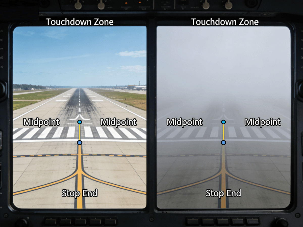
At its most fundamental level, RVR is the horizontal distance a pilot can visually identify key runway features from the cockpit, measured in both meters and feet to align with regional aviation standards—meters for most of the world, including East Asia and the Middle East, and feet for North America. This measurement is not a general estimate of atmospheric clarity; it is a targeted assessment of the runway environment, accounting for runway light intensity, background brightness, and atmospheric conditions like fog, rain, snow, dust, and haze that uniquely impact runway visibility. ICAO defines RVR with strict technical precision, specifying that it must be measured at three critical runway points: the touchdown zone, the midpoint, and the stop end, ensuring a holistic view of the runway’s visual condition for pilots during all phases of landing and takeoff.
RVR differs fundamentally from general meteorological visibility (MV) in its application and accuracy. While MV provides a broad view of atmospheric conditions, it does not account for the specific visual cues pilots rely on—runway lights and markings—that are amplified or diminished by weather. For example, a general visibility reading of 1000 meters may not reflect the actual runway visibility if runway lights are dimmed or obscured by fog, making RVR the only reliable metric for flight operations. This distinction is why ICAO and regional aviation authorities, including the FAA (Federal Aviation Administration) in the US, CAAC (Civil Aviation Administration of China) in East Asia, and GCAA (General Civil Aviation Authority) in the UAE, mandate RVR as the primary visibility standard for all commercial flight operations, especially when MV drops below 1600 meters (5200 feet).
The history of RVR traces back to the mid-20th century, a time when commercial aviation was expanding rapidly and the need for precise visibility measurements became urgent. Early aviation relied on subjective human observations of runway visibility, which were prone to error and inconsistency across different pilots and weather conditions. As jet aircraft emerged and flight speeds increased, the aviation industry demanded an objective, technology-driven solution to measure runway visibility—thus, the concept of RVR was born. Over the decades, RVR measurement technology evolved from basic optical devices to advanced laser and sensor systems, with global airports adopting automated RVR monitoring as standard practice by the 1990s. Today, RVR is an indispensable part of aviation infrastructure, with every major airport in the Americas, Middle East, and East Asia equipped with state-of-the-art RVR measurement equipment to ensure real-time, accurate data for flight crews.
Why RVR Is Non-Negotiable for Flight Safety
Flight safety hinges on informed decision-making, and RVR is the single most important data point for pilots when assessing runway conditions—especially in low-visibility scenarios that account for over 60% of weather-related flight delays and safety incidents worldwide. For pilots, RVR is more than just a number; it is a lifeline that guides every critical action, from adjusting approach speed and descent rate to deciding whether to divert to an alternate airport or execute a go-around. A single incorrect RVR reading can have catastrophic consequences, which is why the aviation industry places the utmost importance on the accuracy, reliability, and real-time availability of RVR data across all operational environments.
In landing operations, RVR directly dictates compliance with ICAO’s instrument landing system (ILS) categories, which define the minimum visibility requirements for safe landings. For example, ILS Category I requires a minimum RVR of 550 meters (1800 feet), while Category II demands 300 meters (1000 feet), and Category III—for zero-visibility landings—relies entirely on automated RVR data and advanced aircraft systems like HUD (Head-Up Display). Pilots must cross-reference real-time RVR readings with their aircraft’s operational limits and airline SOPs (Standard Operating Procedures) to determine if a landing is feasible; if RVR falls below the minimum threshold, a go-around or diversion is the only safe course of action. This is particularly critical in East Asia, where dense fog is common in winter months, and the Middle East, where sudden dust storms can reduce RVR to near zero in a matter of minutes.
For takeoff procedures, RVR is equally vital, as low visibility during the takeoff roll and initial climb-out increases the risk of runway incursions and loss of situational awareness. Most airlines set strict minimum RVR values for takeoff, with values ranging from 150 meters (500 feet) for aircraft equipped with advanced low-visibility takeoff systems to 800 meters (2600 feet) for standard commercial jets. In 2023, CAAC completed a landmark demonstration flight in Beijing, successfully executing a low-visibility takeoff with an RVR of just 150 meters using HUD technology—a breakthrough that highlights how accurate RVR data, paired with advanced aircraft systems, is expanding the operational limits of modern aviation. For North American airports, RVR is critical during winter snowstorms, where plowing and de-icing operations must be coordinated with real-time RVR readings to ensure runways are safe and visible for takeoff.
Adverse weather is the greatest challenge to aviation visibility, and RVR is the only metric that can adapt to the rapid weather changes common across the globe. Fog, the most disruptive weather condition for aviation, can reduce RVR from 2000 meters to less than 50 meters in minutes, while heavy rain and snow can scatter runway light and obscure markings, making RVR measurements the only reliable way to assess actual runway visibility. In the Middle East, sand and dust storms (haboobs) create unique visibility challenges, with fine particles scattering light and reducing RVR even when general visibility appears higher; RVR measurement equipment designed for these harsh conditions is essential for maintaining flight operations. For all these scenarios, real-time RVR updates ensure pilots and air traffic controllers have the data they need to make split-second decisions that protect lives and aircraft.
RVR in METAR: The Global Aviation Weather Standard
METAR (Meteorological Aerodrome Report) is the standardized weather report used by airports and aviation authorities worldwide to communicate real-time atmospheric conditions, and RVR is a critical component of these reports—mandatory for inclusion when visibility drops below 1600 meters (5200 feet) or during adverse weather. For pilots, METAR reports are the primary source of RVR data pre-flight and en route, providing consistent, standardized RVR readings that align with global aviation language and reduce the risk of miscommunication across different regions and languages.
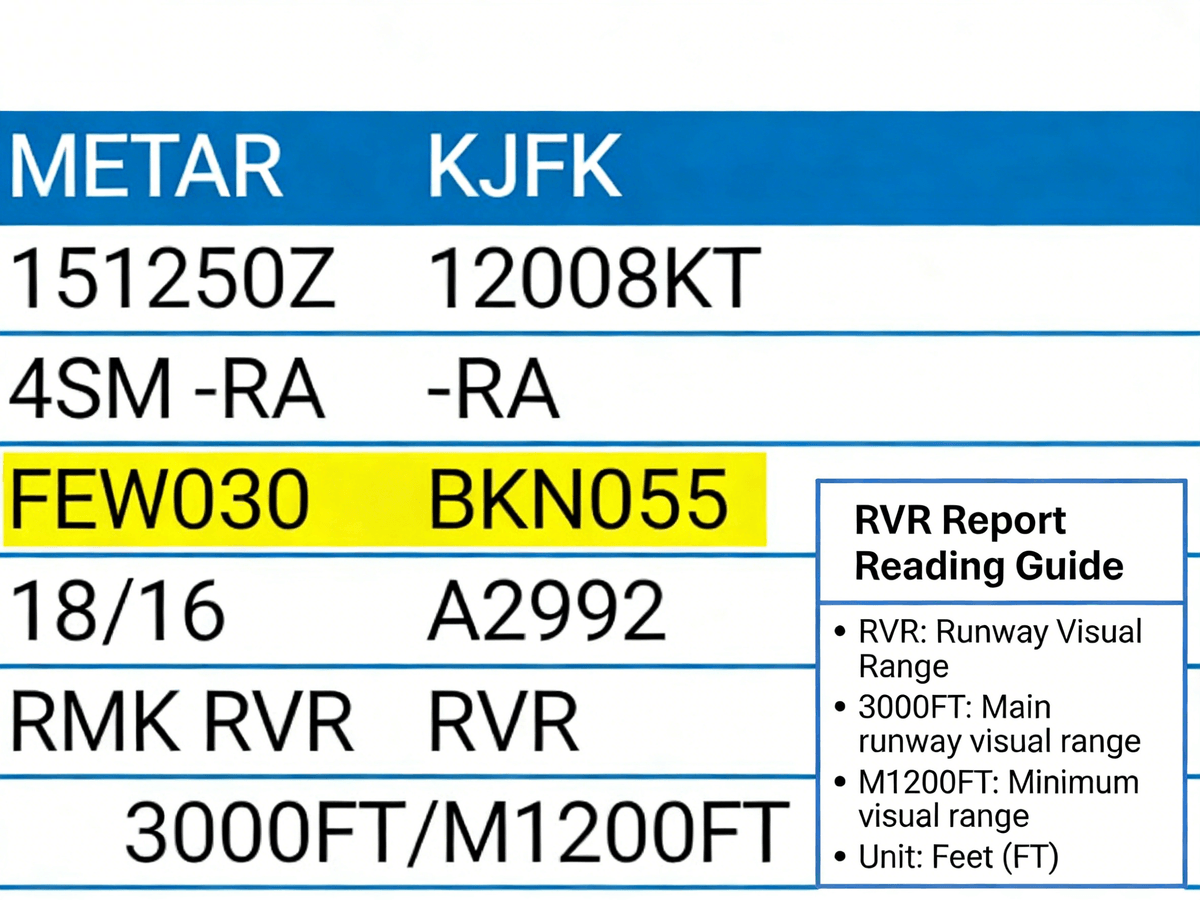
The criteria for RVR reporting in METAR are defined by ICAO, with regional adjustments to align with local aviation regulations. Generally, RVR is reported in METAR at regular 10-to-60-second intervals, or in real time if significant visibility changes are detected—such as a sudden drop in RVR due to fog or a sandstorm. RVR readings in METAR are coded with specific identifiers, including the runway designation, the RVR value (in meters or feet), and a trend indicator (+ for increasing, - for decreasing) to help pilots anticipate visibility changes. For example, a METAR entry for Runway 09 at Dubai International Airport might read “R09/0600M -”, meaning the RVR for Runway 09 is 600 meters and decreasing—critical information for a pilot preparing to land in the Middle East’s variable weather.
In North America, METAR reports use feet for RVR measurements, aligning with FAA standards, while East Asian and Middle Eastern airports use meters, in compliance with ICAO’s metric system. This regional difference is accounted for in global aviation training, with pilots required to be proficient in both units to ensure seamless operations across continents. Additionally, METAR reports include RVR data for all active runways at an airport, allowing pilots and air traffic controllers to select the runway with the best visibility conditions—a key strategy for minimizing delays and enhancing safety during low-visibility operations.
The importance of RVR in METAR extends far beyond the cockpit; ground crews, airport operations managers, and meteorologists all rely on this data to coordinate airport activities. For example, if RVR falls below a certain threshold, ground crews may be instructed to increase runway light intensity (which can boost RVR by 20-40% per ICAO research) or accelerate snow and ice removal operations. Meteorologists use RVR trends to predict visibility changes and issue timely weather advisories, while airport managers use RVR data to adjust gate assignments and flight schedules to minimize disruptions. In short, RVR in METAR is the central data point that unites all airport operations around a single goal: safe, efficient flight operations in all weather conditions.
Precision RVR Measurement: Technology That Powers Global Aviation
Accurate RVR measurements are only possible with advanced, reliable measurement equipment—technology that has evolved dramatically over the past few decades, from basic optical sensors to state-of-the-art laser transmission systems designed to perform in the harshest global aviation environments. For airports and airlines in the Americas, Middle East, and East Asia, investing in high-quality RVR measurement equipment is not just a compliance requirement, but a strategic investment in flight safety, operational efficiency, and passenger confidence.
The gold standard in modern RVR measurement is transmission-based laser technology, exemplified by Haisen’s BHP01 Transmission RVR Measurement Equipment—a cutting-edge system designed to meet and exceed ICAO, FAA, CAAC, and GCAA standards for accuracy and reliability. Unlike older scattering-based sensors, which measure light scattered by atmospheric particles and can be prone to error in heavy fog or sandstorms, transmission-based laser systems measure the attenuation of laser light as it travels along the runway, providing a direct, precise measurement of the distance pilot can see runway lights and markings. This technology is particularly effective in the Middle East’s dusty conditions, East Asia’s dense fog, and North America’s heavy snowfall—making it the most versatile RVR measurement solution for global aviation.
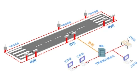
The Haisen BHP01 system is engineered with a laser wavelength optimized for human vision, ensuring that its measurements directly reflect what a pilot actually sees from the cockpit— a critical feature that sets it apart from other RVR measurement systems. The system integrates the ICAO standard algorithm for RVR calculation, combining laser transmission data with runway light intensity and background brightness to deliver real-time RVR readings with an accuracy of ±5%—far exceeding industry standards. Additionally, the BHP01 is fully automated, with 24/7 monitoring and real-time data transmission to the airport’s ATC tower, METAR system, and pilot cockpits, eliminating the need for manual measurements and reducing the risk of human error.
RVR measurement equipment must also be built to withstand the extreme environmental conditions of global aviation. The Haisen BHP01 features a rugged, weatherproof design that operates in temperatures from -40°C to +60°C, making it suitable for the frigid winters of North America, the scorching heat of the Middle East, and the humid conditions of East Asia. The system is also resistant to dust, sand, water, and vibration—critical for airport environments where equipment is exposed to constant wear and tear. For airports looking to minimize maintenance costs, the BHP01 offers remote diagnostic capabilities and a long service life, with minimal calibration required— a key advantage for busy international airports with round-the-clock operations.
Beyond transmission-based laser systems, other RVR measurement technologies include scattering-based sensors and hybrid systems that combine transmission and scattering technology. Scattering-based sensors are smaller and more cost-effective, making them suitable for smaller regional airports with less extreme weather conditions, while hybrid systems offer a balance of accuracy and flexibility for mid-sized airports. However, for major international airports in the Americas, Middle East, and East Asia—where flight volume is high and weather conditions are variable—transmission-based laser systems like the Haisen BHP01 are the clear choice, as they provide the highest level of accuracy and reliability in all operational scenarios.
RVR: Shaping the Future of Global Aviation Safety
The future of aviation is defined by innovation, and RVR technology is at the forefront of this evolution, with new advancements set to make RVR measurements even more accurate, real-time, and integrated with modern aircraft and airport systems. As global air travel continues to grow—with projections of 10 billion passengers annually by 2040—the demand for reliable RVR technology will only increase, making it a key focus for aviation technology providers, airports, and regulatory bodies worldwide.
One of the most exciting developments in RVR technology is the integration of RVR data with advanced aircraft systems like HUD, EFVS (Enhanced Flight Vision Systems), and autonomous flight technology. HUD systems, which project critical flight data onto the pilot’s windscreen, already use real-time RVR data to enhance low-visibility operations, with CAAC’s 150-meter RVR takeoff demonstration flight marking a major milestone in this field. EFVS systems, which use infrared and thermal imaging to enhance pilot visibility, work in tandem with RVR data to reduce minimum visibility requirements for landings and takeoffs, further expanding the operational limits of commercial aircraft. As autonomous flight technology matures, RVR data will be a critical input for AI-powered flight systems, ensuring that autonomous aircraft can make safe, informed decisions in all weather conditions.
Another key trend is the digitization and integration of RVR data into global aviation management systems. Today’s RVR measurement equipment like the Haisen BHP01 already transmits real-time data to airport ATC towers, METAR systems, and airline operations centers, but future systems will integrate RVR data with air traffic management (ATM) systems, flight planning software, and passenger information systems to create a seamless, end-to-end aviation ecosystem. For example, RVR data could automatically update flight plans to select the best runway, notify passengers of minor delays due to low visibility, and coordinate ground operations to minimize disruptions—all in real time. This level of integration will not only enhance flight safety but also significantly improve operational efficiency, reducing weather-related delays by up to 30% according to aviation industry research.
For the aviation industry, the future of RVR also means a greater focus on global standardization and accessibility. ICAO is already working to update its RVR standards to align with new measurement technologies and aircraft systems, with a focus on creating a single, global RVR standard that eliminates regional disparities and enhances cross-continental flight operations. Additionally, there is a growing push to make high-quality RVR measurement equipment accessible to smaller regional airports in developing countries, where low visibility is a major barrier to safe and efficient flight operations. Aviation technology providers like Haisen are leading this effort, developing cost-effective RVR measurement systems that meet ICAO standards and are suitable for regional airport environments.
Why Choose Haisen for Your RVR Measurement Needs?
In a global aviation industry where safety and accuracy are non-negotiable, Haisen stands as a trusted provider of state-of-the-art RVR measurement technology, with a focus on innovation, reliability, and customer-centric design. The Haisen BHP01 Transmission RVR Measurement Equipment is the result of years of research and development, engineered to meet the unique needs of airports and airlines across the Americas, Middle East, and East Asia. With its laser transmission technology, ICAO-compliant algorithm, rugged environmental design, and real-time data transmission capabilities, the BHP01 is the ultimate RVR measurement solution for modern aviation.
Haisen’s commitment to quality extends far beyond its products; the company offers comprehensive customer support, including on-site installation, calibration, training, and 24/7 technical assistance for all its RVR measurement systems. For airports and airlines, this means minimal downtime, maximum operational efficiency, and the peace of mind that comes with partnering with a technology provider that understands the unique challenges of global aviation. Haisen also offers custom RVR measurement solutions, tailored to the specific weather conditions, runway layouts, and operational needs of individual airports—whether it’s a busy international hub in Dubai, a fog-prone airport in Shanghai, or a snow-covered airport in Chicago.
At Haisen, we believe that precision RVR measurement is the foundation of safe, efficient global aviation. Our mission is to provide airports and airlines with the technology they need to navigate any weather condition, minimize delays, and protect the lives of pilots, passengers, and ground crews worldwide. With the Haisen BHP01 Transmission RVR Measurement Equipment, you’re not just investing in a piece of technology—you’re investing in the future of your aviation operations, with a partner that is committed to your success every step of the way.
Conclusion
Runway Visual Range (RVR) is more than just a metric in aviation—it is the unshakable foundation of flight safety, the key to operational efficiency, and the common thread that unites global aviation across continents, weather conditions, and regulatory frameworks. From the dense fog of East Asia to the sandstorms of the Middle East and the snowstorms of North America, RVR is the critical data point that guides every takeoff and landing decision, ensuring that commercial aviation remains the safest mode of transportation in the world.
As aviation technology continues to evolve, RVR will remain at the forefront of flight safety innovation, with new advancements in measurement technology, aircraft systems, and data integration set to make RVR even more accurate and impactful. For airports and airlines, investing in reliable RVR measurement equipment—like Haisen’s BHP01 Transmission RVR Measurement Equipment—is not just a compliance requirement, but a strategic decision that enhances safety, reduces delays, and builds passenger confidence in your operations.
In the end, aviation is about connecting the world—and RVR is the technology that makes that connection safe, no matter what the weather brings. Choose precision, choose reliability, choose Haisen for your RVR measurement needs, and take your aviation operations to new heights of safety and efficiency.
