·
Automated Weather Observing Systems (AWOS) stand as the unshakable foundation of modern airport weather monitoring, delivering real-time, precise meteorological data that defines the safety and efficiency of aviation operations worldwide. Every airport, from small regional airstrips to bustling international hubs, relies on AWOS technology to replace manual weather observations, ensuring consistent, reliable insights for pilots, air traffic controllers, and airport managers who make critical decisions every second. In an industry where weather can alter flight paths and operational plans in an instant, AWOS is not just a tool—it’s a necessity that cuts flight delays, prevents weather-related accidents, and guarantees adherence to global aviation standards set by the FAA and ICAO. This comprehensive guide dives into the inner workings of AWOS, its scalable classifications, proven implementation best practices, maintenance essentials, and the transformative benefits it brings to aviation operations across the Americas, Middle East, and East Asia.
What Exactly Is an Automated Weather Observing System (AWOS)?
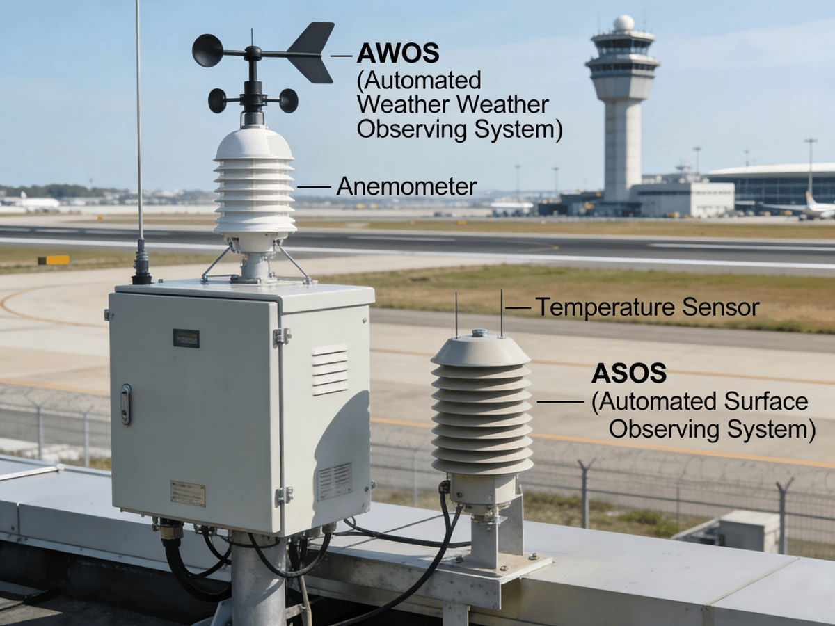
At its core, an AWOS is an integrated network of precision sensors, advanced data processors, and multi-channel communication tools engineered to collect, analyze, and distribute airport-specific weather information 24/7, 365 days a year. Unlike manual weather observations, which are intermittent and prone to human error, an AWOS updates its data as frequently as every minute, capturing rapid weather shifts—from sudden wind gusts and emerging fog banks to unexpected precipitation—that can impact flight safety. The primary mission of any AWOS is to deliver actionable meteorological data that drives every layer of aviation decision-making: for pilots, it means clear visibility, cloud ceiling, and wind condition data before takeoff and landing; for airport operators, it informs runway maintenance, de-icing schedules, and emergency response protocols; for regulatory teams, it ensures unwavering compliance with FAA and ICAO standards that govern global aviation.
The core capabilities of a certified AWOS are what make it indispensable to modern aviation. It provides real-time monitoring of all critical weather parameters, automates data dissemination via VHF radio, telephone, and cloud-based web portals, seamlessly integrates with air traffic control systems, generates standardized aviation weather reports (METARs) recognized globally, and enables remote system monitoring and diagnostics to minimize downtime. A 2023 FAA study quantified the impact of AWOS: airports equipped with certified AWOS systems saw a 35% reduction in weather-related flight cancellations and a 28% drop in weather-induced delays compared to airports relying solely on manual observations. This translates to millions in annual operational cost savings, a testament to how AWOS transforms aviation efficiency at every level.
How Does AWOS Work? The Three Critical Stages
AWOS operates through a seamless, three-step process—data collection, data processing, and data distribution—where every component is calibrated for accuracy and timeliness, two non-negotiables in aviation weather monitoring. No stage is more important than the next; a breakdown in any part of the AWOS workflow can compromise the integrity of the weather data that aviation professionals rely on.
1. Sensor Networks: The Eyes and Ears of AWOS
The AWOS sensor network is the first line of data collection, with specialized sensors strategically placed around the airport to capture weather conditions that reflect real flight scenarios. Sensor placement is a science: wind sensors are mounted on 10-meter tall masts above runway approaches to avoid obstructions, while visibility sensors are positioned 100–300 meters from touchdown zones to measure the exact conditions pilots will encounter. Every AWOS sensor is chosen for its precision, and the suite of sensors scales with the AWOS level, from basic altimeter sensors for small airstrips to advanced precipitation and lightning detectors for major jet airports.
Common AWOS sensors and their critical functions include:
- Anemometers: Measure wind speed (in knots) and direction (referenced to magnetic north), with premium models detecting sudden wind gusts that can destabilize aircraft during takeoff and landing.
- Thermo-hygrometers: Track air temperature, dew point, and relative humidity—key metrics for calculating density altitude, a vital factor in aircraft performance calculations.
- Barometers: Monitor barometric pressure to generate accurate altimeter settings for pilots, ensuring precise altitude readings during flight.
- Ceilometers: Use laser or infrared technology to measure cloud height and coverage (few, scattered, overcast) by calculating the time light pulses take to reflect off cloud bases, critical for IFR (Instrument Flight Rules) operations.
- Visibility Sensors: Detect light scatter to determine horizontal visibility, a make-or-break metric for both VFR (Visual Flight Rules) and IFR flights.
- Precipitation Sensors: Identify precipitation type (rain, snow, freezing rain) and accumulation—found in advanced AWOS models (3P, 3PT, 4)—and alert operators to winter weather hazards.
2. Data Processing: Turning Raw Signals into Actionable Insights
Once AWOS sensors capture raw electrical signals, advanced data processors convert these signals into standardized meteorological values that align with FAA and ICAO standards. Sophisticated algorithms filter out noise, average readings over specific intervals (10-minute averages for visibility, 30-minute averages for cloud cover), and cross-validate data points to eliminate inaccuracies. For example, a ceilometer may take 180 readings in 30 minutes; the AWOS processor analyzes every reading to determine the most consistent cloud height and coverage, avoiding false readings from temporary cloud movements. Wind data is similarly averaged to smooth out minor gusts while still capturing significant wind shifts that impact flight safety.
The AWOS processor also calculates derived weather values that are critical for aviation operations, most notably density altitude. When density altitude exceeds field elevation by more than 1,000 feet, the AWOS automatically computes this metric, which directly impacts aircraft lift and engine performance—especially for takeoffs at high-altitude airports in the Middle East, Rockies, or Himalayas. Every processed data point is quality-checked to ensure it meets FAA certification standards, as unvalidated data cannot be used for official METAR reports or air traffic control decisions.
3. Data Distribution: Getting AWOS Data to Where It Matters Most
AWOS data is only valuable if it reaches the right people at the right time, which is why AWOS systems feature multi-channel data dissemination tailored to aviation professionals’ needs—whether they’re in the cockpit, the control tower, or the airport operations office. The distribution channels are designed for accessibility and speed, ensuring real-time AWOS data is available 24/7 across the Americas, Middle East, and East Asia, regardless of location or device.
- VHF Radio: Pilots receive automated voice reports (20–30 seconds long) on dedicated AWOS frequencies during flight, the most direct way to access real-time airport weather data while in the air.
- Telephone: Ground personnel, including maintenance and de-icing teams, can call a local AWOS number for instant, up-to-the-minute weather updates, critical for on-site operational decisions.
- Cloud-Based Web Portals: Platforms like Mesotech’s AWOS Live display real-time AWOS data on any internet-connected device, making it accessible to airport staff, pilots, and even the public—ideal for remote airports with limited on-site staff in rural areas or the Middle East’s remote aviation hubs.
- FAA Networks: Approved AWOS III (or higher) systems transmit data to the FAA’s Weather Message Switching Center Replacement (WMSCR) via certified third-party providers, where it’s integrated into national METAR reports and shared with aviation authorities worldwide. This integration ensures AWOS data is part of the global aviation weather network, a key benefit for international airports in East Asia, the Americas, and beyond.
AWOS Classifications: Choose the Right System for Your Airport’s Needs
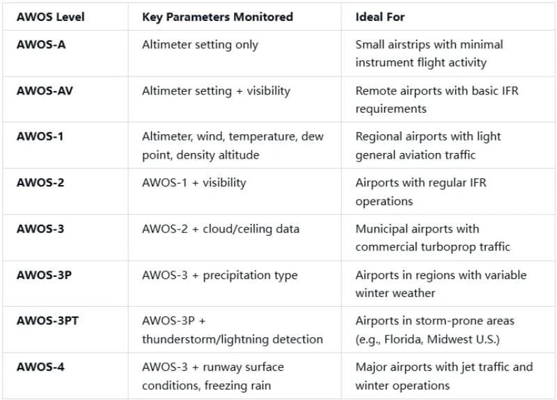
AWOS is a scalable solution, with classifications ranging from AWOS-A to AWOS-4, each designed to match an airport’s size, traffic volume, operational needs, and geographic weather challenges. There is no one-size-fits-all AWOS system: a small rural airstrip in the American heartland has vastly different weather monitoring needs than a major international hub in Dubai or Tokyo, or a regional airport in Canada with harsh winter weather. Understanding AWOS classifications is critical for airport operators, as the right level ensures regulatory compliance, operational efficiency, and cost-effectiveness—while the wrong level can lead to unneeded expenses or insufficient weather data.
The FAA’s 2024 AIM outlines the definitive AWOS level breakdown, with clear key parameters and ideal use cases for each:
- AWOS-A: Monitors only altimeter setting; ideal for small airstrips with minimal instrument flight activity, perfect for private aviation and local general aviation traffic.
- AWOS-AV: Adds visibility monitoring to altimeter setting; designed for remote airports with basic IFR requirements, common in remote regions of the Middle East, Alaska, and rural East Asia.
- AWOS-1: Monitors altimeter, wind, temperature, dew point, and density altitude; ideal for regional airports with light general aviation traffic, the most popular entry-level AWOS for small commercial airports.
- AWOS-2: Builds on AWOS-1 with visibility monitoring; tailored for airports with regular IFR operations, a staple for mid-sized regional airports across the Americas and East Asia.
- AWOS-3: Adds cloud/ceiling data to AWOS-2; designed for municipal airports with commercial turboprop traffic, the standard for airports with regular commercial flights.
- AWOS-3P: Integrates precipitation type detection with AWOS-3; ideal for airports in regions with variable winter weather, such as Canada, the northern U.S., and parts of East Asia with cold winters.
- AWOS-3PT: Adds thunderstorm/lightning detection to AWOS-3P; tailored for storm-prone areas like Florida, the U.S. Midwest, and parts of the Middle East with sudden sandstorms and thunderstorms.
- AWOS-4: The most advanced AWOS level, adding runway surface conditions and freezing rain detection to AWOS-3; designed for major airports with jet traffic and winter operations, the gold standard for international hubs in New York, London, Tokyo, and Dubai.
Real-world AWOS implementations highlight how these classifications align with operational needs. Amos/Magny Airport (CYEY), a regional aerodrome in Quebec, Canada, installed an AWOS-1 system to monitor precipitation accumulation, cloud height, temperature, and barometric pressure—critical for its mix of general aviation and small commercial flights in Canada’s variable weather. Virden Regional Aerodrome (CYVD), a Manitoba airport serving agricultural and passenger traffic, opted for an AWOS-3P system, adding wind, visibility, and present weather detection to handle Canada’s harsh winter conditions, where freezing rain and snow are common hazards. Both airports use cloud-based AWOS Live monitoring, a game-changer for small airports with limited on-site staff, allowing remote access to AWOS data from anywhere in the world— a feature especially valuable for airports in the Middle East and East Asia with geographically dispersed operations.
AWOS vs. ASOS: Key Differences Every Aviation Professional Must Know
AWOS is often confused with Automated Surface Observation Systems (ASOS), another automated weather monitoring system used in aviation. While both AWOS and ASOS generate METAR reports and provide critical weather data for aviation, their core differences in ownership, deployment, reporting intervals, and capabilities make them suited for different airport needs. Understanding the AWOS vs. ASOS distinction is critical for airport operators choosing the right weather system, as it impacts cost, scalability, and data relevance—especially for airports in the Americas, Middle East, and East Asia with unique operational and geographic challenges.
The core contrasts between AWOS and ASOS, sourced from FLYING Magazine 2018 and FAA standards, are clear:
- Ownership: AWOS is typically owned by airports, state governments, or private entities, giving operators full control over the system and its upgrades; ASOS is a cooperative effort by the FAA, NOAA, and DOD, a government-owned system with limited customization.
- Deployment: AWOS is deployed exclusively at airports, focusing on airport-specific weather conditions that impact takeoff and landing; ASOS is deployed at both airports and off-airport locations, making it ideal for route planning and en-route weather monitoring.
- Reporting Interval: AWOS updates data every minute, delivering real-time weather insights critical for non-towered airports and rapid weather changes; ASOS reports hourly, with special reports only for extreme weather shifts, making it less responsive for real-time airport operations.
- Capabilities: AWOS is fully scalable (AWOS-A to AWOS-4), with capabilities matching an airport’s needs and budget; ASOS has fixed capabilities equivalent to AWOS-3 plus total precipitation accumulation, with no scalability for smaller airports.
- Funding: AWOS is funded via FAA Airport Improvement Program (AIP) grants or private funds, giving airports flexibility in budgeting and upgrades; ASOS is 100% government-funded, with limited funding for customization or expansion.
The practical implications of these differences are significant for both pilots and airport managers. For pilots, AWOS’s 1-minute reporting interval is vital for non-towered airports, where pilots rely on real-time weather data to make self-announcemen ts and landing decisions—common in the U.S., rural Middle East, and regional East Asia. ASOS, with its comprehensive precipitation data, is better for en-route flight planning but less useful for real-time airport operations. For airport managers, AWOS offers unrivaled flexibility: a small airport can start with AWOS-1 and upgrade to AWOS-3 or 4 as traffic grows, avoiding the high upfront cost of ASOS. ASOS, a fixed, high-cost solution, is only suited for major international hubs with constant heavy traffic, such as JFK, Dubai International, and Tokyo Haneda.
Notably, both AWOS and ASOS generate standardized METAR reports, and their data supersedes pilot visual observations for VFR landing requirements. A pilot must adhere to AWOS/ASOS-reported visibility and cloud ceiling data, even if their personal observation differs— a critical FAA rule that underscores the importance of certified automated weather data in aviation safety. For most airports, however, AWOS is the more flexible, cost-effective, and responsive choice, especially for airports looking to scale their operations and adapt to changing weather challenges.
Buying & Implementing AWOS: FAA Compliance & Best Practices
Investing in an AWOS system is a critical decision for any airport, and proper planning is essential to ensure FAA compliance, optimal functionality, and long-term value. The FAA sets strict standards for AWOS systems, and non-compliance can result in the system being declared out of service via a NOTAM (Notice to Airmen), disrupting airport operations and compromising safety. Following FAA-approved best practices for AWOS selection, installation, and integration ensures the system delivers on its promise of enhanced safety and efficiency, with minimal downtime and maximum return on investment (ROI) for airports across the Americas, Middle East, and East Asia.
Step 1: Choose an FAA-Approved AWOS System
The first and most critical rule of buying an AWOS is selecting a system from the FAA’s Approved Non-Federal AWOS List. Unapproved AWOS systems cannot generate official METAR reports, may not meet aviation safety requirements, and will not be recognized by air traffic control or regulatory authorities. When choosing an FAA-approved AWOS, key considerations include:
- Matching the AWOS level to your airport’s current and future operations (e.g., AWOS-3P for snow-prone regions, AWOS-3PT for storm-prone areas in the Middle East).
- Ensuring compatibility with your airport’s existing communication infrastructure (VHF radio, internet, cloud platforms) to avoid costly upgrades.
- Verifying access to FAA-certified maintenance technicians for your AWOS make and model—critical for long-term reliability and compliance.
Step 2: Secure Funding & Third-Party Support
Many U.S. airports fund their AWOS systems through the FAA’s Airport Improvement Program (AIP), which provides grants for aviation infrastructure projects, including weather monitoring systems. Airports in the Middle East and East Asia can leverage private funding, government aviation grants, or public-private partnerships to fund AWOS implementation. For AWOS III (or higher) systems, airport operators must contract with an FAA-approved third-party provider to transmit AWOS data to the FAA’s WMSCR network— a requirement for integrating AWOS data into national and global METAR reports, essential for international airports with cross-border flights.
Step 3: Site Preparation & Precision Installation
Proper installation is the foundation of an accurate, reliable AWOS system—even the most advanced sensors will deliver erroneous data if placed incorrectly. FAA guidelines for AWOS installation are strict, and adherence is non-negotiable for compliance and data integrity:
- Sensor Placement: Avoid all obstructions (trees, buildings, power lines) that can block sensors or distort weather readings. Wind sensors must be 10 meters above ground level, and visibility sensors 100–300 meters from runways, in unobstructed areas.
- Vegetation Control: Overgrown bushes, trees, or grass can block sensors and create microclimates that skew data; the FAA recommends regular trimming to maintain clear sensor lines of sight.
- Calibration: All AWOS sensors must be calibrated to FAA standards before activation, ensuring every data point is accurate and meets regulatory requirements. Calibration is especially critical for airports in extreme climates—such as the hot, arid Middle East or the cold, humid regions of East Asia—where weather conditions can impact sensor performance.
Step 4: “Put Your AWOS on the Map”
Once installed and calibrated, verify that your AWOS system is listed on the FAA’s Surface Weather Observation Stations webpage. This critical step ensures pilots, air traffic controllers, and aviation authorities worldwide know your AWOS is operational and where to access its data— a key factor in maximizing the system’s value and ensuring seamless integration into global aviation operations. For international airports in the Middle East and East Asia, this listing also ensures AWOS data is recognized by foreign aviation authorities, a must for international flight operations.
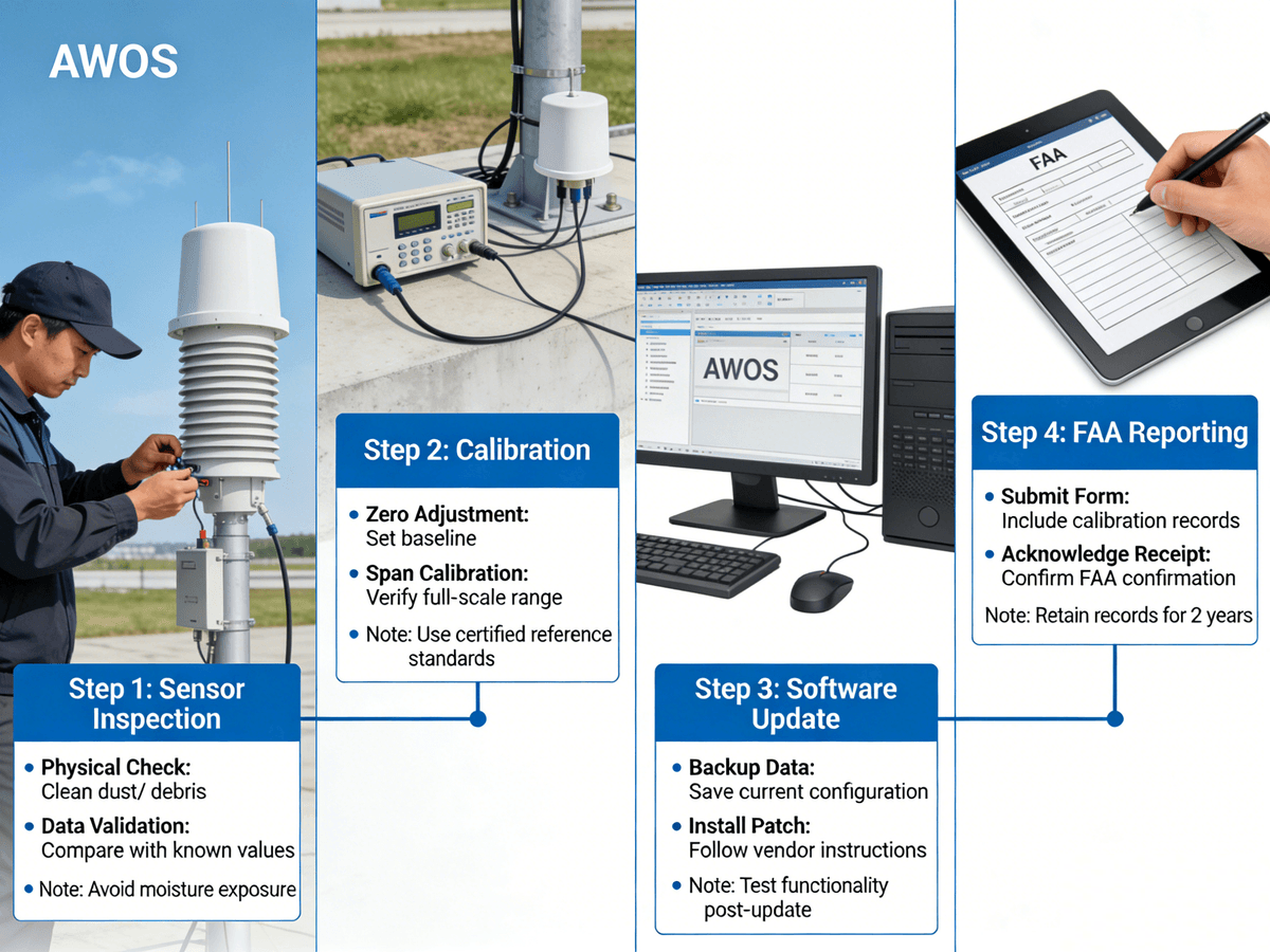
Maintaining AWOS: Avoid Downtime & Compliance Risks
A certified AWOS system is only as reliable as its maintenance program. Neglecting AWOS maintenance can lead to costly downtime, inaccurate weather data, FAA penalties, and even compromised flight safety—risks no airport can afford. Proactive, FAA-compliant maintenance is essential to keep AWOS systems running 24/7, and the best maintenance programs combine routine tasks, real-time remote monitoring, and rapid response to issues. For airports in remote regions of the Middle East, Alaska, or East Asia, where on-site maintenance staff may be limited, remote monitoring is a game-changer that minimizes downtime and ensures AWOS reliability.
Routine AWOS Maintenance Tasks
FAA guidelines outline mandatory routine maintenance tasks for all AWOS systems, with frequency tailored to sensor type and geographic weather conditions:
- Monthly Sensor Inspection: Check wind sensors (anemometers) for debris, visibility sensors for condensation, and ceilometers for lens dirt—common issues that skew data. In the Middle East, sand and dust are major sensor hazards, requiring more frequent inspections.
- FAA-Approved Component Replacement: Use only FAA-certified replacement parts for AWOS sensors and processors; unapproved parts alter system configuration and void FAA certification, rendering the AWOS unfit for official use.
- Regular Software Updates: Keep AWOS data processors updated with the latest FAA-approved firmware to ensure METAR compatibility, regulatory compliance, and access to new features (e.g., AI-driven weather predictions).
- Quarterly Vegetation Management: Trim plants, trees, and grass around sensors to prevent obstruction—critical for airports in lush, green regions of East Asia and the southern U.S.
Coordinating with the FAA for Maintenance & Outages
Transparency with the FAA is key to AWOS compliance. Inform the FAA of all planned AWOS maintenance events in advance to avoid unexpected NOTAMs that disrupt airport operations. For unplanned AWOS outages (e.g., sensor failure, communication line issues), notify the FAA immediately and post a NOTAM to alert pilots and air traffic controllers— a FAA requirement that ensures aviation professionals are aware of missing weather data. Many AWOS providers offer cloud-based remote monitoring tools (e.g., AWOS Live) that detect issues like sensor failures or data transmission errors before they cause downtime, allowing maintenance teams to address problems proactively— a feature especially valuable for remote airports.
Common AWOS Issues & Proven Solutions
Even with proactive maintenance, AWOS systems can face common issues, especially in extreme weather conditions. Knowing the root causes and proven solutions ensures rapid resolution and minimal downtime:
- Erroneous Wind Data: Caused by debris in anemometers; solve with monthly sensor cleaning and protective screens (essential in the Middle East’s sandy climates).
- Inaccurate Visibility Readings: Caused by condensation on visibility sensors; solve with heated sensor housings and regular calibration (critical for cold, humid regions of East Asia and Canada).
- Cloud Height Errors: Caused by sensor obstruction from trees or buildings; solve with vegetation trimming and sensor repositioning.
- Data Transmission Failures: Caused by broken communication lines or internet outages; solve with redundant internet/radio links, a must for airports in remote regions with unreliable connectivity.
The Future of AWOS: Innovation Driving Aviation Safety
AWOS technology is constantly evolving, driven by advances in sensor technology, connectivity, artificial intelligence (AI), and global aviation standardization. The future of AWOS is focused on making weather monitoring more predictive, accessible, and integrated into smart airport operations— a shift that will further enhance aviation safety and efficiency across the Americas, Middle East, and East Asia. These innovations are not just incremental upgrades; they are transformative changes that turn AWOS from a real-time weather monitoring tool into a predictive weather intelligence system that anticipates hazards before they impact airports.
1. IoT & Cloud Integration: Anytime, Anywhere AWOS Data
Modern AWOS systems leverage the Internet of Things (IoT) to connect sensors wirelessly, eliminating the need for costly wired infrastructure and reducing installation time— a major benefit for remote airports and new aviation hubs in the Middle East and East Asia. IoT-enabled AWOS sensors transmit data in real time to cloud-based platforms like AWOS Live, allowing airport managers to access weather data, receive alerts, and monitor system performance from any internet-connected device—whether in the airport operations office, a remote office, or on the go. Cloud integration also enables seamless data sharing between airports, air traffic control, and airlines, creating a unified aviation weather network that enhances safety across entire regions.
2. Artificial Intelligence (AI): Predictive AWOS for Proactive Decision-Making
AI algorithms are being integrated into AWOS systems to predict weather changes 15–30 minutes before they impact runways— a game-changer for aviation safety. This “predictive AWOS” can forecast fog formation, sudden wind shifts, or freezing rain, giving pilots and airport operators extra time to adjust schedules, initiate de-icing, or close runways if needed. In the Middle East, AI-powered AWOS can predict sandstorm formation, a major aviation hazard, while in East Asia, it can forecast typhoon-related weather shifts. Predictive AWOS eliminates the “reactionary” approach to weather and enables a proactive approach that cuts delays and prevents accidents.
3. Advanced Runway Surface Monitoring
The latest AWOS-4 systems feature cutting-edge sensors that measure runway friction, surface temperature, and moisture levels, detecting icy or slippery conditions before they become hazardous. This data integrates seamlessly with airport snow removal and de-icing teams’ workflows, optimizing de-icing efforts and reducing runway closure time— a critical benefit for airports in winter-prone regions of the U.S., Canada, and East Asia, and for high-traffic hubs that cannot afford extended runway closures. For the Middle East, these sensors also detect sand accumulation on runways, a common hazard that impacts flight safety.
4. Global Standardization: Aligning with ICAO for Cross-Border Reliability
As aviation becomes more interconnected, AWOS systems are aligning with ICAO global standards to ensure data consistency across borders. This means a pilot flying from New York to Dubai to Tokyo can trust the same AWOS data format, accuracy, and metrics at every airport— eliminating confusion and enhancing safety for international flights. Global standardization is also making it easier for airports in the Middle East and East Asia to adopt AWOS technology, as FAA-approved AWOS systems now meet ICAO standards, reducing regulatory barriers and ensuring cross-border recognition.
Why Your Airport Needs AWOS: Safety, Efficiency, & Unbeatable ROI
For every airport—small regional airstrips, mid-sized commercial hubs, and major international jet airports—AWOS delivers tangible, measurable benefits that justify the investment. In an industry where weather is the number one cause of flight delays and accidents, AWOS is not just a technology upgrade; it’s a strategic investment in safety, efficiency, and regulatory compliance that pays for itself in months. The benefits of AWOS extend far beyond weather monitoring, impacting every aspect of airport operations and delivering value to pilots, airport operators, airlines, and passengers alike— across the Americas, Middle East, and East Asia.
1. Enhanced Aviation Safety
AWOS eliminates human error in manual weather observations and provides 24/7 monitoring of rapidly changing weather conditions, the leading cause of weather-related aviation accidents. The FAA reports that airports with certified AWOS systems have a 40% lower rate of weather-related accidents compared to airports without AWOS. For example, AWOS-3PT’s lightning detection alerts pilots and air traffic controllers to approaching thunderstorms, preventing takeoffs into dangerous weather— a critical safety feature for storm-prone regions. In the Middle East, AWOS sandstorm detection and in East Asia, typhoon weather monitoring, save lives and prevent aircraft damage by alerting operators to hazards before they arrive.
2. Reduced Operational Costs
Weather-related delays cost airlines $3 billion annually in the U.S. alone— and the numbers are equally staggering for airlines in the Middle East and East Asia. AWOS minimizes these costs by providing accurate, real-time weather data that allows for better scheduling and operational planning. If AWOS predicts visibility will drop below IFR minimums in 45 minutes, airlines can adjust departure times, avoiding costly gate fees, passenger rebooking costs, and fuel waste from idling aircraft. For airport operators, AWOS reduces maintenance costs by informing runway and de-icing schedules, ensuring resources are used efficiently and only when needed. The 2023 FAA study confirmed that AWOS delivers millions in annual operational cost savings for airports of all sizes.
3. Unwavering Regulatory Compliance
FAA and ICAO require automated weather observations for most commercial airports worldwide, and AWOS is the most flexible, cost-effective way to meet these requirements. Non-compliance can result in fines, NOTAMs that shut down operations, and even the loss of commercial flight rights— risks no airport can afford. A certified AWOS system ensures continuous compliance with all FAA and ICAO weather monitoring standards, eliminating regulatory stress and ensuring seamless airport operations. For international airports in the Middle East and East Asia, AWOS compliance also ensures recognition by foreign aviation authorities, a must for cross-border flight operations.
4. Improved Pilot Confidence & Operational Trust
Pilots rely on accurate weather data to make the most critical decisions of their careers— and AWOS delivers that data consistently, 24/7. A 2024 AOPA (Aircraft Owners and Pilots Association) survey found that 92% of general aviation pilots consider AWOS a “must-have” for non-towered airports, where no air traffic controller is on staff to provide weather updates. For commercial pilots, AWOS data provides the objective, certified weather information needed to make takeoff, landing, and diversion decisions— building trust in airport operations and enhancing overall flight safety. In the Middle East and East Asia, where many regional airports are non-towered, AWOS is a lifeline for pilots operating in remote, weather-challenged regions.
Choosing the Right AWOS Partner: Your Key to Success
Selecting the right AWOS system is only half the battle— choosing the right AWOS provider is the other half that determines long-term success. A reputable AWOS partner ensures smooth installation, FAA compliance, proactive maintenance, and 24/7 support— critical for airports that rely on AWOS for safe, efficient operations. For airports in the Americas, Middle East, and East Asia, choosing a provider with regional expertise, FAA approval, and a track record of success is essential to maximizing the AWOS investment and minimizing downtime.
Key Qualifications to Look for in an AWOS Provider
When evaluating AWOS providers, prioritize these non-negotiable qualifications:
1. FAA Approval: Verify the provider’s systems are on the FAA’s Approved Non-Federal AWOS List— the gold standard for AWOS certification.
2. Technical Expertise: Look for providers with FAA-certified technicians who handle installation, calibration, and repairs— no third-party contractors needed.
3. Remote Monitoring Capabilities: Choose a provider with cloud-based tools (e.g., AWOS Live) for real-time system oversight and proactive issue detection.
4. Regional Industry Experience: Prioritize providers with a track record in your region— e.g., winter weather expertise for northern airports, sand and dust expertise for the Middle East, and typhoon weather expertise for East Asia.
5. 24/7 Global Support: Ensure the provider offers 24/7 technical support, with response teams available to address issues in all time zones— critical for international airports and remote aviation hubs.
Case Study: Mesotech International— A Leading AWOS Provider
Mesotech International exemplifies what a top-tier AWOS provider should be, with 30+ years of experience, FAA/ICAO approval, and a global footprint serving 200+ military installations and civilian airports across the Americas, Middle East, and East Asia. Mesotech’s customized AWOS solutions are tailored to each airport’s unique needs, from entry-level AWOS-1 systems for small airstrips to advanced AWOS-4 systems for major international hubs. Their work at Canadian airports CYEY and CYVD delivered cloud-based AWOS Live monitoring, remote access, and regional weather expertise— enhancing safety and efficiency for regional aviation in Canada’s harsh weather. Mesotech’s 24/7 global support and FAA-certified technicians ensure their AWOS systems run reliably, with minimal downtime— a hallmark of their commitment to aviation safety.
Final Thoughts: AWOS— The Future of Airport Weather Monitoring
Automated Weather Observing Systems (AWOS) are more than just weather tools— they are the foundational technology of modern aviation safety and efficiency. From the simplest AWOS-A for small airstrips to the advanced AWOS-4 for major international hubs, AWOS delivers the real-time, predictive weather data that keeps planes in the air, passengers safe, and airports running smoothly— across the Americas, Middle East, and East Asia. As weather patterns grow more variable and aviation traffic increases, AWOS will only become more critical, with AI, IoT, and global standardization driving the next generation of predictive weather intelligence.
Whether you’re upgrading an existing AWOS system, installing your first AWOS, or expanding your airport’s weather monitoring capabilities, focusing on FAA compliance, scalability, and a reputable provider is the key to success. The investment in AWOS is not just a financial one— it’s an investment in the safety of your pilots, passengers, and staff, and in the long-term efficiency and growth of your airport.
Ready to elevate your airport’s weather monitoring capabilities with a certified, scalable AWOS system? Our team of FAA-approved AWOS experts has the regional expertise, technical know-how, and global support to design a customized AWOS solution that meets your airport’s current needs and future goals. Contact us today to learn how AWOS can transform your aviation operations, cut delays, and enhance safety— for every flight, every day.