DME in Aviation is the unsung cornerstone of modern air travel, delivering the precise distance data that keeps pilots, aircraft, and passengers safe across every phase of flight. From private propellers to commercial airliners, this ground-based radio navigation system isn’t just a regulatory requirement—it’s a trusted ally that outperforms other tools in reliability, accuracy, and versatility. In this expanded guide, we’ll explore why DME remains irreplaceable in aviation, dive deeper into its technical mechanics, showcase real-world applications across diverse aircraft types, and explain how Haisen Aviation’s cutting-edge DME solutions elevate safety, efficiency, and cost-effectiveness for operators worldwide. Whether you’re a general aviation enthusiast, a commercial fleet manager, or a military aviation professional, understanding DME’s power will transform how you approach flight operations.
What Is DME in Aviation? The Core of Precision Distance Measurement
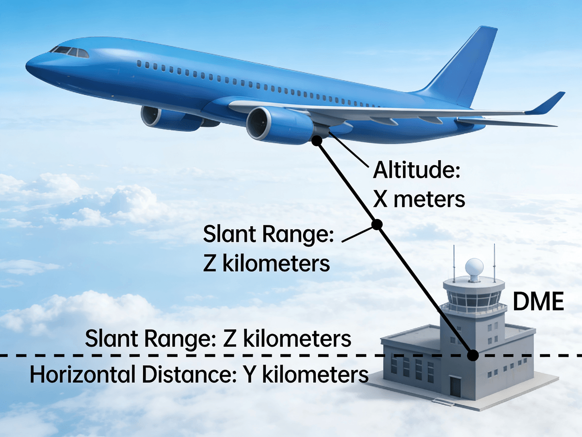
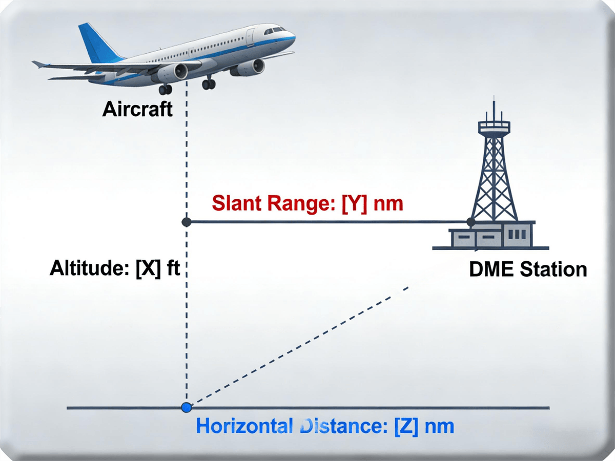
At its essence, DME (Distance Measuring Equipment) is a specialized radio navigation system designed to calculate the slant range distance between an aircraft and a fixed ground-based DME station. Unlike GPS, which relies on satellite signals, or VOR, which focuses on directional guidance, DME’s sole purpose is to provide real-time, accurate distance readings in nautical miles (NM)—making it a unique and non-negotiable tool for aviation safety.
Key Definitions: Slant Range vs. Horizontal Distance
A critical distinction in DME functionality is the difference between slant range and horizontal distance. Slant range refers to the straight-line distance between the aircraft and the ground DME station, accounting for both horizontal separation and vertical altitude. For instance, if an aircraft flies at 15,000 feet with a horizontal distance of 8 NM from a DME station, the slant range will register slightly more than 8 NM due to the vertical component. While this variance is negligible at low altitudes or long distances (often less than 0.1 NM), it becomes crucial during critical phases like final approach, where even minor discrepancies can impact safety. DME’s ability to measure slant range ensures pilots have an unfiltered view of their proximity to waypoints, airports, and restricted airspace—eliminating guesswork when it matters most.
Who Relies on DME in Aviation? Every Segment of the Industry
DME’s versatility makes it indispensable across the entire aviation spectrum, from small private planes to large-scale commercial and military operations. Here’s how different operators leverage DME’s capabilities:
General Aviation
Private pilots flying single-engine Cessnas, Piper Cubs, or Cirrus SR22s depend on DME to navigate remote regions where GPS signals may be weak, intermittent, or blocked by terrain. For example, a pilot traveling to a rural airport in the Rocky Mountains uses DME to confirm their position relative to a nearby DME station, ensuring they stay on course through mountain passes and avoid uncharted airspace. DME’s simplicity and reliability make it ideal for general aviation, where pilots often operate with limited avionics and rely on standalone tools for navigation.
Commercial Airlines
Major carriers operating Boeing 787s, Airbus A350s, and other wide-body jets use DME to comply with strict ATC instructions, maintain airway boundaries, and execute precision instrument approaches. During transatlantic or transpacific flights, DME works in tandem with other navigation systems to keep aircraft on designated routes, ensuring separation from other planes and adherence to fuel-efficient flight plans. For example, a Delta Air Lines flight from Atlanta to London uses DME to monitor its distance from VOR/DME stations along the North Atlantic Tracks, adjusting course to stay within airway limits and optimize fuel consumption.
Helicopter Operations
Emergency medical services (EMS) helicopters and offshore transport operators rely on DME to hover at safe distances from hospitals, oil rigs, and other critical locations—even in low-visibility conditions like fog or heavy rain. An EMS helicopter responding to a rural emergency uses DME to maintain a precise distance from a hospital’s DME station, ensuring a safe approach and landing in confined spaces. Offshore helicopter pilots use DME to navigate between oil rigs, where GPS signals may be disrupted by metal structures, relying on DME’s ground-based signals for consistent accuracy.
Military Aviation
Military pilots use DME (often paired with TACAN systems) for tactical navigation, including low-level flights, mission-specific waypoint tracking, and combat operations. Fighter jets like the F-16 or F-35 use DME to maintain formation, avoid enemy airspace, and execute precision strikes. For example, a military pilot on a reconnaissance mission uses DME to navigate to a series of waypoints, ensuring they stay within designated operational areas and avoid detection. DME’s resistance to jamming and interference makes it a critical tool for military operations, where reliability can mean the difference between mission success and failure.
Why DME in Aviation Is Non-Negotiable: Regulatory Mandates and Safety Standards
Global aviation authorities—including the International Civil Aviation Organization (ICAO), the U.S. Federal Aviation Administration (FAA), and the European Union Aviation Safety Agency (EASA)—mandate DME for all instrument flight rules (IFR) operations. IFR flights rely on non-visual navigation, and DME ensures pilots can:
- Comply with ATC instructions (e.g., “Maintain DME 10 from the Chicago VOR until further clearance”).
- Execute instrument approaches (e.g., DME Arc, ILS/DME, or RNAV/DME approaches).
- Avoid restricted airspace (e.g., “Remain outside DME 5 of the military operating area”).
- Maintain safe separation from other aircraft during takeoff, climb, cruise, and descent.
Even visual flight rules (VFR) pilots benefit from DME, using it to confirm their position, avoid collisions, and navigate through areas with limited visual references. For example, a VFR pilot flying over the Grand Canyon uses DME to stay within safe distances from canyon walls and other aircraft, ensuring a smooth and secure flight.
Beyond regulatory compliance, DME’s safety benefits are unmatched. Unlike GPS, which can suffer from multipath interference (signals bouncing off buildings or terrain) or satellite outages, DME’s ground-based signals are consistent and reliable. DME works in all weather conditions—fog, rain, snow, or darkness—ensuring pilots have access to critical distance data when other systems fail. This reliability makes DME a vital backup for GPS, providing a redundant navigation solution that enhances safety during every flight.
How Does DME in Aviation Work? A Technical Deep Dive
DME’s functionality is based on a simple yet powerful principle: measuring the time it takes for radio waves to travel between an aircraft and a ground station. Operating on ultra-high frequency (UHF) radio waves (960–1215 MHz)—a band reserved for aviation to minimize interference—DME delivers pinpoint accuracy with a typical error margin of less than 0.1 NM. Let’s break down the technology step by step:
The DME System: Two Core Components
Every DME system consists of two essential parts: the airborne DME transceiver (installed in the aircraft’s avionics bay) and the ground-based DME station (located at airports, waypoints, or along airways). These components work in harmony to calculate distance, with advanced features that enhance performance and reliability.

Step 1: The Airborne Transceiver Sends Pulsed Signals
The airborne DME transceiver initiates the process by sending a series of paired pulsed radio signals to the ground DME station. These pulses are unique to DME, with a specific time interval (12 microseconds) between each pulse in a pair. This unique pattern ensures ground stations don’t confuse DME signals with those from other navigation systems like VOR or ILS.
Haisen Aviation’s airborne DME transceivers take this technology to the next level with AI-powered signal encoding. This advanced feature reduces interference from other radio sources, even in busy airspaces like over major cities or hub airports. For example, during peak hours at New York’s JFK Airport, where hundreds of aircraft are in the air simultaneously, Haisen’s transceivers ensure DME signals remain clear and recognizable—critical for maintaining accuracy in high-traffic environments.
Step 2: The Ground Station Responds Instantly
When the ground-based DME station receives the aircraft’s pulsed signals, it immediately transmits a reply signal—also a series of paired pulses timed to match the incoming pattern. Ground DME stations are designed to handle dozens (even hundreds) of aircraft simultaneously, processing and responding to signals without delays or interference.
Haisen’s ground DME stations are built for maximum reliability, with redundant transmitters/receivers, backup power supplies (batteries and generators), and remote monitoring capabilities. This means even during power outages, extreme weather, or technical issues, Haisen’s ground stations stay operational—ensuring aircraft never lose access to critical distance data. For example, during a hurricane in Florida, a Haisen ground DME station at Miami International Airport remained fully functional thanks to its backup generator, providing essential navigation data to aircraft diverting to the airport.
Step 3: Time Measurement and Distance Calculation
Once the airborne transceiver sends a signal, it starts a precision timer. When it receives the ground station’s reply, the timer stops, and the transceiver calculates the round-trip time (the time it took for the signal to travel to the station and back). Using the known speed of radio waves (approximately 186,000 miles per second, or 300,000 kilometers per second), the DME converts this time into distance using the formula:
Distance (NM) = (Round-Trip Time in Microseconds × 0.0001667)
For example, if the round-trip time is 1,200 microseconds, the distance would be 1,200 × 0.0001667 = 0.2 NM. This level of precision makes DME ideal for critical flight phases like final approach, where even a small distance error could lead to a hazard.
Step 4: Data Display and Enhanced Features
The calculated distance is displayed on the aircraft’s navigation panel, typically as a digital or analog readout in nautical miles. Advanced DME systems like Haisen’s offer additional features that improve situational awareness and reduce pilot workload:
- Groundspeed Calculation: Derived from continuous distance measurements. For example, if DME decreases by 5 NM in 1 minute, the groundspeed is 300 knots.
- Time-to-Station: Calculated by dividing the current distance by groundspeed. For example, 60 NM ÷ 5 NM per minute = 12 minutes to station.
- Custom Distance Alerts: Pilots can set alerts for critical distances, such as “Alert when DME reaches 3 NM for final approach.”
- Multifunctional Displays (MFDs): Integrate DME data with VOR, GPS, and ILS information, reducing cockpit clutter and providing a comprehensive navigation view.
Haisen’s DME displays are designed for maximum visibility, with high-contrast digital screens that work in both bright sunlight and night conditions. The displays also feature intuitive controls and customizable layouts, allowing pilots to tailor the information to their specific needs.
DME in Aviation: Outperforming Other Navigation Systems
While GPS and VOR are valuable navigation tools, DME offers unique advantages that make it irreplaceable in critical scenarios:
No Weather Interference
Unlike visual navigation (which fails in low visibility) or GPS (which can be disrupted by severe weather), DME works in all weather conditions. Radio waves aren’t blocked by clouds, snow, or storms, so DME remains reliable even when other systems fail. For example, during a blizzard at Denver International Airport, DME allowed pilots to execute safe instrument approaches while GPS signals were intermittent due to atmospheric interference.
High-Speed Precision
Even at speeds exceeding 600 mph (typical for commercial jets), DME maintains accuracy within 0.1 NM. This is critical during takeoff and climb, where pilots need to reach specific altitudes at precise DME distances to comply with noise abatement rules and air traffic control instructions. For example, a Boeing 747 climbing at 600 mph uses DME to ensure it reaches 3,000 feet by DME 5 from the airport—avoiding fines and reducing noise pollution in residential areas.
No Multipath Errors
GPS signals can bounce off buildings, terrain, or water (multipath interference), leading to inaccurate readings. DME’s ground-based signals avoid this issue, ensuring accuracy even near airports with tall structures or in urban environments. For example, at Tokyo’s Haneda Airport, where skyscrapers surround the airfield, DME provides reliable distance data while GPS signals are often distorted by multipath interference.
Redundancy and Backup
DME serves as a vital backup for GPS, ensuring pilots have a reliable navigation solution if GPS fails. In the event of a satellite outage or signal jamming, DME continues to provide accurate distance data, allowing pilots to complete their flight safely. This redundancy is mandated by aviation authorities for IFR operations, as it reduces the risk of navigation system failure.

DME in Every Flight Phase: From Takeoff to Landing
DME is integral to every phase of flight, providing critical distance data that keeps pilots on course, compliant with regulations, and safe from hazards. Let’s explore how DME supports flight operations from pre-takeoff to post-landing:
Pre-Takeoff and Taxiing: Preventing Runway Incursions
Before takeoff, pilots use DME to verify their position relative to nearby DME stations—ensuring they’re on the correct taxiway and aligned with the runway. This is especially critical at large airports with complex layouts, where taxiway mix-ups are a leading cause of runway incursions (a top aviation safety hazard).
Real-World Example: A pilot at Los Angeles International Airport (LAX) receives ATC instructions: “Cleared to taxi to Runway 25L, maintain DME 1.5 from the central DME station.” Using Haisen’s DME display, the pilot monitors the readout as they taxi. If the DME drops below 1.5, the pilot knows they’re getting too close to the station and adjusts their path—avoiding accidental entry into a closed taxiway or active runway.
Haisen’s DME transceivers integrate with airport mapping systems, overlaying DME data on taxiway charts. This helps pilots quickly confirm their location, even in low-visibility conditions like fog or heavy rain. For example, at Frankfurt Airport, where fog is common during winter months, Haisen’s DME integration with taxiway maps reduces taxi time and improves safety by eliminating confusion.
Takeoff and Climb: Noise Compliance and Aircraft Separation
During takeoff and climb, DME plays two critical roles: adhering to noise abatement procedures and maintaining safe separation from other aircraft.
Noise Abatement: Many airports near residential areas have strict noise abatement rules that require aircraft to reach specific altitudes at certain DME distances. For example, London Heathrow Airport mandates: “Climb to 2,000 feet by DME 3 from the airport.” Pilots use DME to monitor their progress—if they’re not at 2,000 feet when DME reaches 3, they adjust their climb rate to avoid fines and reduce noise pollution.
Haisen’s DME systems include “noise abatement alerts,” which notify pilots when they’re approaching a critical DME/altitude checkpoint. This ensures compliance without requiring the pilot to constantly monitor the display, reducing workload during the busy takeoff phase.
Aircraft Separation: ATC uses DME distances to assign vertical or horizontal spacing between climbing aircraft. For example, ATC might instruct: “Maintain DME 7 from the departure station, then turn right heading 180.” This ensures the aircraft doesn’t come too close to another plane climbing on a parallel route.
Haisen’s long-range DME transceivers (covering up to 199 NM) provide early visibility of other aircraft’s DME positions (via ATC data integration), allowing pilots to anticipate turns and adjustments—reducing stress and improving safety. For example, a Southwest Airlines flight climbing out of Dallas Love Field uses Haisen’s DME to monitor the distance from a nearby American Airlines flight, ensuring they maintain the required separation.

Cruising: Staying on Course and Optimizing Fuel
Cruise flight is the longest phase of most flights, and DME is essential for staying on airway routes, maintaining separation from other aircraft, and calculating fuel consumption.
Airway Navigation: Most airways (designated routes in the sky) are defined using DME distances from VOR/DME or standalone DME stations. For example, “Airway J123 runs from Dallas/Fort Worth VOR/DME Station (DME 0) to Houston Intercontinental VOR/DME Station (DME 200).” Airways are typically 5 NM wide on either side of the centerline, and pilots use DME to ensure they stay within these boundaries—avoiding restricted airspace or other airways.
Haisen’s DME systems include “airway boundary alerts,” which warn pilots if they drift beyond the 5 NM limit. This is especially useful during long-haul flights, where pilot fatigue can lead to small course deviations. For example, a Qatar Airways flight from Doha to New York uses Haisen’s DME to stay within the boundaries of Airway B456, ensuring compliance with ATC instructions and avoiding restricted airspace over the Atlantic Ocean.
Fuel Calculation: Knowing the exact DME distance to the next waypoint allows pilots to estimate fuel consumption with precision. For example, if an Airbus A380 is cruising at 480 knots and the next waypoint is 240 NM away, the pilot can calculate they’ll use approximately 5,000 gallons of fuel (based on the aircraft’s fuel burn rate). This prevents fuel shortages—one of the most stressful emergencies in aviation.
Haisen’s DME integrates with aircraft fuel management systems, automatically updating fuel estimates as DME distance changes. This reduces manual calculations and human error, ensuring pilots have accurate fuel data throughout the flight. For example, a United Airlines flight from Chicago to Los Angeles uses Haisen’s DME-fuel integration to adjust its speed and altitude, optimizing fuel efficiency and reducing costs.
Holding Patterns: When an airport is busy, ATC may instruct pilots to enter a holding pattern—circular flight paths defined by DME. A typical holding pattern might be: “Hold at DME 15 from the Miami VOR/DME Station, right turns, 1.5-minute legs.” Pilots use DME to stay within the holding area (e.g., not drifting below DME 14 or above DME 16), ensuring they don’t enter restricted airspace.
Haisen’s DME displays include a “holding pattern overlay,” showing the DME boundaries and leg length—making it easy for pilots to maintain the pattern, even in busy airspace. For example, during peak hours at Atlanta Hartsfield-Jackson International Airport, dozens of aircraft use Haisen’s DME to maintain holding patterns, reducing congestion and improving air traffic flow.
Descent and Approach: Precision for Safe Landings
Descent and approach are the most critical phases of flight, and DME is the backbone of instrument approach procedures (IAPs). Without DME, pilots would lack the precision needed to execute safe approaches—especially in low visibility.
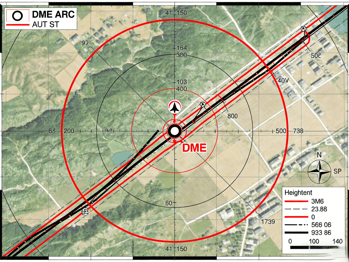
DME Arc Approaches: Many airports use DME Arc approaches, where aircraft fly a circular path around a DME station at a specific distance until reaching the final approach course. For example, at Seattle-Tacoma International Airport, the “DME Arc 10 NM” approach requires aircraft to fly a 10 NM circle around the Seattle VOR/DME Station, adjusting their heading to maintain the arc, until they reach the final approach fix for Runway 16R.
Haisen’s DME systems use advanced algorithms to calculate the exact heading needed to maintain the arc, reducing pilot workload. The display shows a real-time “arc deviation” indicator, letting pilots know if they’re too close or too far from the station. For example, a Delta Air Lines flight using Haisen’s DME maintains the 10 NM arc with precision, even in turbulent weather, ensuring a smooth transition to the final approach course.
Decision Heights (DH) and Minimum Descent Altitudes (MDA): DME is used to define decision points during approaches. For example, a non-precision approach might specify: “At DME 2 from the airport, minimum descent altitude (MDA) is 800 feet.” This means pilots can descend to 800 feet only when they reach DME 2—and if they don’t see the runway by that point, they must initiate a “go-around” (abort the approach).
Haisen’s DME displays include a “descent calculator,” which shows the pilot how much altitude they need to lose to reach MDA by the critical DME point. This ensures smooth, controlled descents, even in low-visibility conditions. For example, a Southwest Airlines flight approaching Phoenix Sky Harbor International Airport uses Haisen’s descent calculator to adjust its rate of descent, reaching MDA exactly at DME 2 and ensuring a safe approach.
Precision Approaches (ILS/DME): ILS (Instrument Landing System) is a precision approach system that provides lateral (localizer) and vertical (glideslope) guidance. When paired with DME (ILS/DME), it adds critical distance markers:
- Outer Marker: Typically at DME 6, indicating the start of the final approach.
- Middle Marker: At DME 3, reminding pilots to prepare for glideslope capture.
- Inner Marker: At DME 0.5, indicating the runway threshold is near.
Haisen’s ILS/DME integration ensures these markers are displayed in real time, with alerts when the aircraft reaches each DME point. This is especially valuable in low-visibility conditions, where pilots rely entirely on instrument data. For example, during a foggy morning at Tokyo Haneda Airport, a Japan Airlines flight uses Haisen’s ILS/DME system to execute a precision approach, landing safely even with visibility below 1,000 feet.
Landing and Rollout: Preventing Runway Overshoots
Even after landing, DME continues to add value. During rollout (the phase after touchdown), pilots use DME to confirm their distance from the runway threshold—ensuring they exit at the correct taxiway.
Real-World Example: A pilot landing at Dallas-Fort Worth International Airport receives instructions: “Exit Runway 35L at Taxiway E, located at DME 1.2 from the threshold.” Using Haisen’s DME display, the pilot monitors the readout as they roll down the runway. When DME reaches 1.2, they turn onto Taxiway E—avoiding overshooting the exit and blocking the runway for other aircraft.
Haisen’s DME also records rollout data, which pilots can review during post-flight debriefs. This helps identify areas for improvement, such as adjusting braking to exit at the correct DME point. For example, a FedEx cargo pilot reviews DME rollout data after a flight, noticing they exited at DME 1.3 instead of 1.2—adjusting their braking technique for future flights to ensure precision.
The Cost-Effectiveness of DME in Aviation: A Long-Term Investment
DME is one of the most cost-effective navigation systems in aviation, offering low upfront costs, minimal maintenance, and long lifespans. Here’s why DME delivers exceptional value for operators:
Low Maintenance Requirements
DME ground stations are built to last 15–20 years with minimal maintenance. Haisen’s ground DME stations include remote monitoring, so maintenance teams only need to visit sites when issues arise—not for routine checks. This reduces labor costs and downtime, ensuring maximum operational efficiency. Airborne DME transceivers also have a long lifespan (10+ years) and require only annual calibration, further reducing maintenance expenses.
Widespread Availability Eliminates Infrastructure Costs
There are thousands of DME stations worldwide—installed at airports, waypoints, and along airways. This means operators don’t need to build new infrastructure to use DME; they can leverage existing stations. Haisen’s DME systems are compatible with all global DME stations, so operators don’t need to invest in proprietary infrastructure. For example, a small general aviation operator in Australia can install Haisen’s DME transceiver and immediately use it with existing DME stations across the country—no additional infrastructure required.
Compatibility with Old and New Aircraft
DME works with every aircraft type, from 1970s-era prop planes to 2025-model airliners. This means operators don’t need to upgrade their entire fleet to use DME—they can install Haisen’s DME transceivers in older aircraft without replacing other avionics. A small charter company in Europe saved $30,000 by upgrading only the DME system in their fleet of 1980s-era Piper Navajos, instead of replacing the entire avionics suite.
Reduced Operational Costs
DME’s precision and reliability help reduce operational costs by minimizing fuel waste, avoiding fines for regulatory non-compliance, and reducing the risk of accidents. For example, a commercial airline using Haisen’s DME saves an average of $$50,000 per year in fuel costs by optimizing flight paths and reducing course deviations. Additionally, DME’s role in noise abatement compliance helps avoid fines of up to$$10,000 per violation, further reducing operational expenses.
Why Choose Haisen Aviation for DME in Aviation?
Haisen Aviation’s DME solutions stand out as the top choice for aviation professionals worldwide, offering proven reliability, cutting-edge technology, custom solutions, and exceptional support. Here’s what makes Haisen’s DME systems superior:
Proven Reliability
Haisen’s DME transceivers and ground stations are built to withstand the harshest aviation environments, with a 99.9% operational uptime. Rigorously tested to meet ICAO, FAA, and EASA standards, Haisen’s DME systems have been trusted by airlines, military forces, and general aviation operators for over a decade.
Cutting-Edge Technology
Haisen’s DME systems feature AI-powered signal encoding, advanced algorithms for arc approaches and descent calculations, and integration with modern avionics like multifunctional displays (MFDs) and fuel management systems. These features enhance accuracy, reduce pilot workload, and improve situational awareness.
Custom Solutions
Haisen offers tailored DME solutions for every aircraft type and operation, from small prop planes to large airliners. Whether you need a lightweight DME transceiver for a helicopter or a long-range system for a commercial jet, Haisen’s team of experts will design a solution that meets your specific needs.
Exceptional Support
Haisen provides 24/7 technical support, remote monitoring, and on-site maintenance services to ensure your DME systems are always operating at peak performance. Our team of DME experts is available to answer questions, troubleshoot issues, and provide training for your pilots and maintenance staff.
Take the Next Step: Upgrade Your Fleet’s DME in Aviation
DME in Aviation is more than just a navigation tool—it’s an investment in the safety, efficiency, and success of your aviation operations. With Haisen Aviation’s cutting-edge DME solutions, you can enhance safety, reduce costs, and optimize every phase of flight.
Ready to upgrade your fleet’s DME? Contact Haisen Aviation today to:
- Request a free quote for DME transceivers or ground stations.
- Schedule a demo of Haisen’s DME systems (in-person or online).
- Speak with a DME expert to design a custom solution for your needs.
Don’t compromise on safety or efficiency—choose Haisen Aviation’s DME solutions and fly with confidence.