AWOS in Aviation stands as an indispensable pillar of modern flight safety, delivering continuous, precise weather insights that pilots and air traffic controllers depend on. In the high-stakes world of aviation, where split-second decisions can mean the difference between a smooth flight and a hazardous situation, having access to real-time meteorological data isn’t just a convenience—it’s a non-negotiable requirement. Every takeoff, landing, and in-flight adjustment relies on accurate information about temperature, wind patterns, visibility, and other critical weather parameters, and AWOS (Automated Weather Observing System) is the technology that makes this constant flow of data possible. From small regional airports to major international hubs, AWOS in Aviation has become a cornerstone of operational efficiency, reducing risks and ensuring that flights proceed with maximum safety. In this comprehensive guide, we’ll dive deep into what AWOS in Aviation entails, its key components, how it compares to similar systems like ASOS and ATIS, the differences between AWOS 1 and AWOS 2, and why it’s a game-changer for anyone involved in aviation operations.

What Exactly Is AWOS in Aviation?
To understand the critical role of AWOS in Aviation, we first need to break down its core definition and functionality. AWOS, or Automated Weather Observing System, is an advanced, sensor-driven technology designed specifically for airport environments to collect, process, and distribute real-time weather data. Unlike manual weather observations, which are prone to human error and limited by time constraints, AWOS in Aviation operates 24/7, providing continuous updates that reflect the most current atmospheric conditions. Its primary mission is to supply pilots, air traffic controllers, and flight planners with accurate, actionable information that directly impacts flight safety and operational decisions.
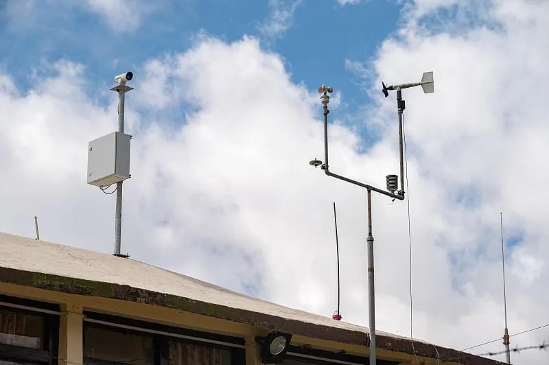
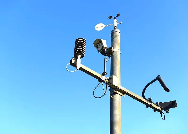
At its heart, AWOS in Aviation is a network of specialized sensors and data processing units that work in harmony to measure key meteorological parameters. These parameters include:
- Air temperature and dew point: Critical for assessing icing risks and engine performance.
- Wind speed and direction: Essential for determining runway suitability and takeoff/landing dynamics.
- Visibility: A make-or-break factor for safe approach and landing, especially in low-visibility conditions like fog or rain.
- Cloud height and cover: Vital for avoiding turbulence and ensuring proper clearance during flight.
- Atmospheric pressure: Important for calculating altitude and understanding weather system movements.
- Precipitation type and intensity (in advanced models): Helps pilots prepare for challenges like heavy rain, snow, or sleet.
The magic of AWOS in Aviation lies in its ability to turn raw sensor data into usable information—fast. These systems are engineered to process measurements in real time, sending updates to airport control towers, pilot cockpits, and flight planning software within seconds. For pilots, this means having access to up-to-the-minute weather conditions at their destination or any airport along their route, allowing them to adjust flight paths, delay takeoffs, or switch runways if sudden weather changes occur. For air traffic controllers, AWOS in Aviation provides the data needed to manage air traffic flow efficiently, ensuring that planes maintain safe distances and land under optimal conditions.
But AWOS in Aviation isn’t just about collecting data—it’s about reliability. Modern AWOS systems, like Haisen's Aviation Automatic Weather Observation Station, are built to withstand harsh environmental conditions, from extreme temperatures to heavy rain, snow, and high winds. They undergo rigorous testing to ensure accuracy even in the most challenging weather scenarios, making them a trusted source of information for aviation professionals worldwide. Whether it’s a small private airport or a bustling international hub, AWOS in Aviation adapts to the unique needs of each location, providing tailored data that meets the specific requirements of the airport’s operations.
Why AWOS in Aviation Is Non-Negotiable for Flight Safety
The importance of AWOS in Aviation cannot be overstated when it comes to protecting lives and assets in the sky. Aviation is an industry where weather-related incidents account for a significant portion of accidents and near-misses. According to the Federal Aviation Administration (FAA), weather is a contributing factor in approximately 20% of all aviation accidents, with issues like sudden wind shear, low visibility, and icing being among the top culprits. AWOS in Aviation directly addresses these risks by providing the real-time data needed to anticipate and mitigate weather-related hazards.
Consider a scenario where a pilot is preparing to land at a regional airport. Without AWOS in Aviation, they might rely on outdated weather reports or visual observations from the ground, which can be misleading. A sudden drop in visibility due to fog or a shift in wind direction could catch them off guard, leading to a dangerous landing attempt. With AWOS in Aviation, however, the pilot receives continuous updates on visibility, wind speed, and direction, allowing them to abort the landing if conditions deteriorate beyond safe limits. This split-second decision, enabled by AWOS in Aviation, can mean the difference between a safe go-around and a catastrophic incident.
Another critical area where AWOS in Aviation shines is in flight planning. Before a flight even takes off, pilots use AWOS data to assess weather conditions at their departure airport, destination, and any alternate airports they might need to use. This information helps them determine the best route, calculate fuel requirements, and identify potential weather hazards along the way. For example, if AWOS in Aviation at a destination airport reports strong crosswinds that exceed the aircraft’s operating limits, the pilot can adjust the flight plan to land at an alternate airport with more favorable conditions. This proactive approach, made possible by AWOS in Aviation, reduces the risk of in-flight emergencies and ensures that flights are only conducted when it’s safe to do so.
AWOS in Aviation also plays a key role in enhancing operational efficiency. By providing accurate, real-time weather data, it helps airports reduce delays and cancellations caused by uncertainty about weather conditions. For example, if AWOS in Aviation shows that a storm is passing through an airport but will clear up within 30 minutes, air traffic controllers can hold flights in a holding pattern rather than canceling them, saving time and money for airlines and passengers alike. Additionally, AWOS in Aviation helps airports optimize runway usage by providing data on wind direction and speed, allowing controllers to assign the most efficient runway for takeoffs and landings, reducing congestion and improving overall airport throughput.

For airlines and aviation companies, investing in AWOS in Aviation isn’t just a safety measure—it’s a smart business decision. Weather-related delays and cancellations cost the aviation industry billions of dollars each year in lost revenue, passenger compensation, and additional operational expenses. By leveraging AWOS in Aviation to make more informed decisions, airlines can minimize these costs while improving customer satisfaction. Passengers are more likely to trust an airline that prioritizes safety and reliability, and AWOS in Aviation is a visible demonstration of that commitment.
AWOS vs. ASOS: Which Is Better for Aviation?
When discussing AWOS in Aviation, one question that frequently arises is how it compares to ASOS (Automated Surface Observing System). Both systems are designed to provide weather data for aviation, but they differ in their scope, focus, and capabilities. Understanding these differences is crucial for pilots, air traffic controllers, and airport operators to choose the right system for their needs.
First, let’s recap what we know about AWOS in Aviation. As we’ve discussed, AWOS is a specialized system tailored to airport environments, providing continuous, real-time weather data on key parameters like temperature, wind speed and direction, visibility, and cloud height. It’s designed to meet the specific needs of pilots and airport operations, with a focus on localized, airport-specific data that’s critical for takeoffs, landings, and in-flight decisions. AWOS in Aviation is available in different models (like AWOS 1 and AWOS 2, which we’ll explore later) to accommodate the needs of different-sized airports, from small general aviation fields to large commercial hubs.
ASOS, on the other hand, is a more comprehensive system that provides weather data for a broader range of applications, including aviation, meteorology, and climate monitoring. Developed through a partnership between the FAA, National Weather Service (NWS), and Department of Defense (DoD), ASOS is designed to collect data from surface locations across the country, including airports, weather stations, and remote areas. While ASOS does provide many of the same weather parameters as AWOS in Aviation—such as temperature, wind speed, visibility, and precipitation—it’s designed to serve a wider audience, not just aviation professionals.

Let’s dive deeper into the key differences between AWOS in Aviation and ASOS:
Focus and Scope
AWOS in Aviation is laser-focused on airport operations. It’s installed directly at airports and provides data that’s tailored to the unique needs of pilots and air traffic controllers. The data from AWOS in Aviation is localized to the airport’s immediate area, ensuring that pilots have accurate information about the specific conditions they’ll encounter during takeoff and landing. This is especially important for airports located in areas with variable weather patterns, where conditions can change rapidly within a small geographic area.
ASOS, by contrast, has a broader scope. It’s designed to provide weather data for entire regions, not just individual airports. ASOS stations are located across the country, including in remote areas where there are no airports, and their data is used by meteorologists to track weather systems, issue forecasts, and monitor climate trends. While ASOS data is useful for aviation, it’s not as focused on the specific needs of airport operations. For example, an ASOS station located 10 miles from an airport may report different weather conditions than the airport itself, which can be misleading for pilots preparing to land.
Update Frequency
One of the biggest advantages of AWOS in Aviation is its update frequency. Most AWOS systems update their data every minute or even more frequently, providing near-instantaneous insights into changing weather conditions. This real-time updates are critical for aviation, where conditions can shift in a matter of seconds. For example, a sudden gust of wind or a drop in visibility can happen without warning, and AWOS in Aviation ensures that pilots and air traffic controllers are notified immediately.
ASOS, on the other hand, typically updates its data every 15 minutes. While this is sufficient for general weather monitoring and forecasting, it’s not ideal for aviation operations, where real-time data is essential. A 15-minute delay in weather updates can mean the difference between a safe landing and a dangerous situation, especially in rapidly changing weather conditions.
Data Parameters
Both AWOS in Aviation and ASOS provide core weather parameters like temperature, wind speed and direction, visibility, and cloud height. However, AWOS in Aviation often offers more specialized data for aviation-specific needs. For example, advanced AWOS models (like AWOS 2) can measure precipitation type and intensity, which is critical for pilots preparing to land in snowy or rainy conditions. AWOS in Aviation may also provide data on runway surface conditions, such as whether the runway is wet, icy, or dry, which is essential for determining takeoff and landing distances.
ASOS provides a more comprehensive set of meteorological data, including parameters like humidity, pressure tendency, and snow depth. While this data is useful for general weather forecasting, it’s not always relevant to aviation operations. For pilots, the key data points are those that directly impact flight safety during takeoff, landing, and in-flight operations, which AWOS in Aviation is specifically designed to deliver.
Ideal Use Cases
So, when should you use AWOS in Aviation versus ASOS? The answer depends on your specific needs:
- Use AWOS in Aviation if: You’re a pilot preparing to take off or land at a specific airport, an air traffic controller managing airport operations, or an airport operator looking to enhance safety and efficiency. AWOS in Aviation is the best choice for anyone who needs localized, real-time data about the immediate weather conditions at an airport. It’s especially valuable for airports with variable weather patterns or those located in areas prone to sudden weather changes.
- Use ASOS if: You’re a meteorologist tracking regional weather systems, a flight planner looking to assess broad weather trends across a route, or a pilot flying long distances who needs to get a general sense of weather conditions in a region. ASOS is useful for providing a big-picture view of weather patterns, but it shouldn’t be relied on as the sole source of data for takeoffs and landings.
The key takeaway is that AWOS in Aviation and ASOS are complementary systems, not competitors. Many airports use both systems: AWOS in Aviation for real-time, airport-specific data, and ASOS for regional weather context. By combining data from both systems, pilots and air traffic controllers can get a complete picture of weather conditions, making more informed decisions that enhance safety and efficiency.
AWOS 1 vs. AWOS 2: Choosing the Right Model for Your Airport
Now that we’ve explored the role of AWOS in Aviation and how it compares to ASOS, let’s take a closer look at the different models of AWOS available. The two most common models are AWOS 1 and AWOS 2, each designed to meet the needs of different-sized airports and operational requirements. Understanding the differences between these models is crucial for airport operators looking to invest in AWOS in Aviation, as it ensures that they choose a system that aligns with their specific needs and budget.
Key Features of AWOS 1
AWOS 1 is the entry-level model in the AWOS lineup, designed for small airports, general aviation fields, and heliports. It provides the basic weather data needed for safe flight operations, focusing on the core parameters that pilots need to make critical decisions. The key features of AWOS 1 include:
- Core Weather Parameters: AWOS 1 measures temperature, wind speed and direction, visibility, cloud cover, and barometric pressure. These are the essential data points for pilots operating in relatively stable weather conditions, where advanced data like precipitation type isn’t necessary.
- Real-Time Updates: Like all AWOS systems, AWOS 1 updates its data every minute, ensuring that pilots have access to the most current weather conditions.
- Simple Installation and Maintenance: AWOS 1 is designed to be easy to install and maintain, making it a cost-effective option for small airports with limited resources. It requires minimal infrastructure and can be operated with basic training.
- Communication Options: AWOS 1 typically offers multiple communication channels, including radio broadcasts, digital displays in the control tower, and integration with flight planning software. This ensures that pilots can access the data in the format that’s most convenient for them.
AWOS 1 is an ideal choice for small airports that primarily serve private pilots, flight schools, and small commercial operators. It provides the essential weather data needed to ensure safe operations without the added cost and complexity of advanced features. For example, a small airport in a region with mild weather year-round may not need to measure precipitation type or intensity, making AWOS 1 the perfect fit.
Key Features of AWOS 2
AWOS 2 is the next step up from AWOS 1, designed for larger regional airports, commercial airports, and airports located in areas with variable or challenging weather conditions. It builds on the core features of AWOS 1 by adding advanced sensors and data parameters that provide more detailed insights into weather conditions. The key features of AWOS 2 include:
- Advanced Weather Parameters: In addition to the core parameters measured by AWOS 1, AWOS 2 adds measurements for precipitation type (rain, snow, sleet) and intensity, as well as cloud height (specifically the height of the lowest cloud layer). These data points are critical for pilots operating in adverse weather conditions, where knowing the type and intensity of precipitation or the exact height of clouds can make a significant difference in flight safety.
- Enhanced Sensor Technology: AWOS 2 uses more advanced sensors than AWOS 1, including optical sensors for measuring visibility and precipitation, and laser sensors for determining cloud height. These sensors provide greater accuracy and reliability, even in challenging weather conditions like heavy fog or snow.
- Customizable Alerts: AWOS 2 allows airport operators to set up customizable alerts for specific weather conditions, such as low visibility, high winds, or heavy precipitation. These alerts can be sent to pilots, air traffic controllers, and airport staff via email, text message, or radio broadcast, ensuring that everyone is notified immediately when conditions deteriorate.
- Integration with Airport Systems: AWOS 2 is designed to integrate seamlessly with other airport systems, including air traffic control software, runway lighting systems, and passenger information displays. This integration allows for a more streamlined operational workflow, as weather data can be automatically shared across different systems without manual input.
AWOS 2 is an ideal choice for airports that serve commercial airlines, handle a high volume of flights, or are located in areas with unpredictable weather. For example, an airport in the northern United States that experiences heavy snowfall in the winter would benefit greatly from AWOS 2’s ability to measure snow intensity and cloud height, helping pilots prepare for safe landings in snowy conditions. Similarly, a regional airport with multiple runways would appreciate the customizable alerts and system integration features of AWOS 2, which help streamline operations and enhance safety.
Choosing Between AWOS 1 and AWOS 2
When deciding between AWOS 1 and AWOS 2, airport operators should consider the following factors:
- Airport Size and Traffic Volume: Small airports with low traffic volume and primarily general aviation operations will likely find AWOS 1 sufficient. Larger airports with commercial flights and higher traffic volume will benefit from the advanced features of AWOS 2.
- Weather Conditions: Airports located in regions with mild, stable weather can get by with AWOS 1. Airports in areas with variable weather, heavy precipitation, or low visibility should opt for AWOS 2 to ensure that pilots have access to the detailed data they need.
- Budget and Resources: AWOS 1 is a more cost-effective option, with lower installation and maintenance costs. AWOS 2 requires a larger upfront investment but provides greater value for airports with more complex operational needs.
- Regulatory Requirements: Some airports may be required by regulatory bodies (like the FAA) to have a certain level of weather monitoring capability. Airport operators should check local regulations to ensure that they choose a system that meets compliance standards.
Ultimately, the choice between AWOS 1 and AWOS 2 comes down to balancing needs and resources. Both models are reliable, accurate, and designed to enhance the safety of AWOS in Aviation operations. By choosing the right model, airport operators can ensure that they’re providing pilots and air traffic controllers with the data they need to make informed decisions, while staying within their budget.
AWOS vs. ATIS: Understanding the Critical Differences
Another common point of confusion in the world of aviation weather data is the difference between AWOS in Aviation and ATIS (Automatic Terminal Information Service). While both systems provide weather-related information to pilots, they serve distinct purposes and should not be confused with one another. Understanding the differences between AWOS and ATIS is crucial for pilots, as it ensures that they use the right tool for the right situation.
What Is ATIS?
First, let’s define ATIS. ATIS is an automated broadcast system that provides pilots with a consolidated message containing weather data, operational information, and other critical updates for a specific airport. Unlike AWOS in Aviation, which focuses solely on weather data, ATIS combines weather information with operational details that pilots need to know before arriving at or departing from an airport. These details include:
- Active runways (including runway configurations and closures)
- NOTAMs (Notices to Airmen) about temporary changes, such as construction, equipment outages, or airspace restrictions
- Airport services available (e.g., fuel, maintenance, ground transportation)
- Traffic patterns and procedures for arriving and departing flights
ATIS messages are pre-recorded and updated periodically (typically every hour or when there’s a significant change in weather or operational conditions). Pilots can tune into a specific radio frequency to listen to the ATIS message before contacting air traffic control, allowing them to familiarize themselves with important information and reduce the amount of time spent communicating with controllers.

Key Differences Between AWOS and ATIS
Now, let’s compare AWOS in Aviation and ATIS to highlight their critical differences:
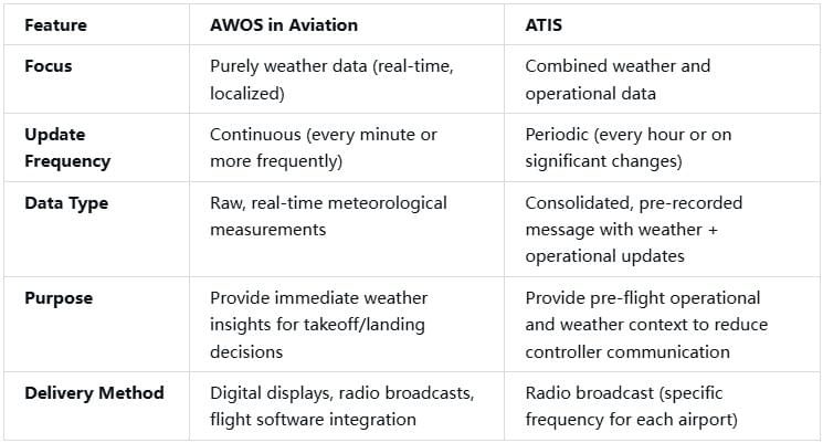
The most significant difference between AWOS in Aviation and ATIS is their focus. AWOS in Aviation is all about real-time weather data—providing pilots with the most current conditions at the airport to help them make immediate decisions during takeoff, landing, or in-flight. ATIS, on the other hand, is about consolidation—combining weather data with operational information to give pilots a comprehensive overview of what to expect at the airport before they arrive.
Another key difference is update frequency. AWOS in Aviation updates continuously, ensuring that pilots have access to the latest weather conditions. ATIS, by contrast, is updated periodically, which means that the weather information in an ATIS message may not be as current as the data from AWOS in Aviation. For example, if a sudden thunderstorm rolls into an airport 30 minutes after the last ATIS update, the ATIS message won’t reflect the new weather conditions, but AWOS in Aviation will.
When to Use AWOS vs. ATIS
Pilots should use both AWOS in Aviation and ATIS as part of their pre-flight and in-flight preparation, but for different purposes:
- Use AWOS in Aviation when: You need real-time weather data to make immediate decisions. This includes during approach and landing, when you need to know the current visibility, wind speed, and direction to safely land the plane. It also includes during takeoff, when you need to ensure that weather conditions are within the aircraft’s operating limits. AWOS in Aviation is also useful during in-flight, when you may need to check weather conditions at an alternate airport if you encounter unexpected weather.
- Use ATIS when: You’re preparing for a flight (pre-flight planning) or approaching an airport and want to get a comprehensive overview of operational conditions. ATIS helps you understand which runways are active, if there are any NOTAMs that could affect your flight, and what services are available at the airport. This information helps you plan your approach and reduce the amount of time you spend communicating with air traffic control, which is especially important at busy airports.
In practice, pilots will often use both systems in conjunction. For example, during pre-flight planning, a pilot might listen to the ATIS message to get operational details and a general sense of the weather, then check AWOS in Aviation for the most current weather conditions at the airport. During approach, the pilot will continue to monitor AWOS in Aviation to ensure that weather conditions haven’t changed since the last ATIS update. This combination of AWOS in Aviation and ATIS ensures that pilots have all the information they need to make safe, informed decisions.
The Future of AWOS in Aviation: Innovations and Trends
As technology continues to advance, AWOS in Aviation is evolving to meet the changing needs of the aviation industry. New innovations and trends are shaping the future of AWOS, making it even more accurate, reliable, and useful for pilots, air traffic controllers, and airport operators. Let’s take a look at some of the key trends that are driving the future of AWOS in Aviation.
1. Enhanced Sensor Technology
One of the biggest trends in AWOS in Aviation is the development of more advanced sensors. Modern sensors are becoming more accurate, reliable, and capable of measuring a wider range of weather parameters. For example, new visibility sensors use laser technology to provide more precise measurements in low-visibility conditions like fog or smoke. Precipitation sensors are now able to distinguish between different types of precipitation (rain, snow, sleet, hail) with greater accuracy, helping pilots prepare for specific weather challenges.
Another innovation in sensor technology is the use of remote sensing. Some AWOS systems now use radar and satellite data to supplement ground-based sensors, providing a more comprehensive view of weather conditions. This remote sensing capability allows AWOS in Aviation to detect weather hazards like wind shear or turbulence before they reach the airport, giving pilots and air traffic controllers more time to respond.
2. Artificial Intelligence (AI) and Machine Learning
AI and machine learning are transforming many industries, and aviation is no exception. In the world of AWOS in Aviation, AI is being used to analyze large amounts of weather data and identify patterns that humans might miss. For example, AI algorithms can analyze historical weather data to predict future weather conditions at an airport, helping pilots and flight planners make more accurate decisions.
AI is also being used to improve the reliability of AWOS systems. Machine learning algorithms can detect anomalies in sensor data, such as a faulty sensor reading, and automatically correct or flag the issue. This helps ensure that the data provided by AWOS in Aviation is always accurate and reliable, reducing the risk of incorrect decisions based on bad data.
3. Integration with Other Aviation Systems
As aviation becomes more connected, AWOS in Aviation is being integrated with other systems to create a more seamless operational workflow. For example, AWOS data is now being integrated with flight management systems (FMS) in cockpits, allowing pilots to access real-time weather data directly on their navigation displays. This integration eliminates the need for pilots to switch between different systems to check weather conditions, reducing distraction and improving situational awareness.
AWOS in Aviation is also being integrated with air traffic management (ATM) systems, allowing air traffic controllers to access real-time weather data alongside flight tracking information. This integration helps controllers make more informed decisions about air traffic flow, ensuring that planes are routed around weather hazards and land under optimal conditions.
4. Portable and Mobile AWOS Systems
Another trend in AWOS in Aviation is the development of portable and mobile systems. These systems are designed for temporary use at airports, heliports, or construction sites where a permanent AWOS installation isn’t feasible. Portable AWOS systems are lightweight, easy to set up, and can be deployed in a matter of hours, making them ideal for emergency situations or temporary operations.
Mobile AWOS systems are also being developed for use in remote areas, such as bush airports or military bases. These systems can be mounted on vehicles or trailers, allowing them to be moved to different locations as needed. This flexibility makes AWOS in Aviation accessible to more airports and operations, regardless of their location or infrastructure.
Why Choose Haisen’s AWOS Systems for Your Airport?
When it comes to investing in AWOS in Aviation, choosing the right provider is just as important as choosing the right model. Haisen Global is a leading provider of aviation weather systems, offering a range of AWOS solutions designed to meet the needs of airports of all sizes. Here’s why you should choose Haisen’s AWOS systems for your airport:
1. Cutting-Edge Technology
Haisen’s AWOS systems are built using the latest sensor technology and data processing algorithms, ensuring that they provide accurate, real-time weather data. Our systems are designed to withstand harsh environmental conditions, from extreme temperatures to heavy rain, snow, and high winds, making them a reliable choice for any airport.
2. Customizable Solutions
We understand that every airport has unique needs, which is why we offer customizable AWOS solutions. Whether you need a basic AWOS 1 system for a small general aviation airport or an advanced AWOS 2 system for a large commercial hub, we can tailor our solution to meet your specific requirements. Our team of experts will work with you to assess your needs and design a system that fits your budget and operational goals.
3. Easy Installation and Maintenance
Haisen’s AWOS systems are designed to be easy to install and maintain, reducing downtime and operational costs. Our systems come with comprehensive documentation and training materials, ensuring that your staff can operate and maintain the system with minimal effort. We also offer ongoing technical support, so you can rest assured that help is available if you encounter any issues.
4. Compliance with Industry Standards
All of Haisen’s AWOS systems are compliant with international aviation standards, including those set by the FAA, ICAO (International Civil Aviation Organization), and EASA (European Union Aviation Safety Agency). This ensures that your airport meets regulatory requirements and that your AWOS data is accepted by pilots, air traffic controllers, and flight planning software worldwide.
5. Proven Track Record
Haisen Global has a proven track record of providing high-quality AWOS systems to airports around the world. Our systems are trusted by airlines, air traffic control authorities, and airport operators, and we have a reputation for delivering reliable, accurate, and cost-effective solutions. When you choose Haisen, you’re choosing a partner with the experience and expertise to help you enhance the safety and efficiency of your airport operations.
Conclusion: AWOS in Aviation—Your Partner for Safe, Efficient Flights
AWOS in Aviation is more than just a weather monitoring system—it’s a critical partner in ensuring the safety and efficiency of flight operations. From providing real-time weather data for takeoffs and landings to helping pilots and air traffic controllers make informed decisions, AWOS in Aviation plays a pivotal role in every aspect of aviation. Whether you’re a pilot, an air traffic controller, or an airport operator, investing in AWOS in Aviation is an investment in safety, reliability, and operational excellence.
Throughout this guide, we’ve explored what AWOS in Aviation is, why it’s essential for flight safety, how it compares to systems like ASOS and ATIS, the differences between AWOS 1 and AWOS 2, and the future trends shaping the industry. We’ve also highlighted why Haisen’s AWOS systems are the ideal choice for airports of all sizes, with their cutting-edge technology, customizable solutions, and proven track record.
As aviation continues to evolve, AWOS in Aviation will remain at the forefront of flight safety, adapting to new technologies and changing needs to provide even more accurate, reliable, and useful data. Whether you’re operating a small general aviation airport or a large international hub, AWOS in Aviation is the key to ensuring that your flights are safe, efficient, and successful.
If you’re ready to enhance the safety and efficiency of your airport operations with AWOS in Aviation, contact Haisen Global today. Our team of experts will work with you to assess your needs, design a customized solution, and provide ongoing support to ensure that your AWOS system delivers the results you need. With Haisen’s AWOS systems, you can trust that you’re getting the best in aviation weather technology—so you can focus on what matters most: keeping your flights safe.