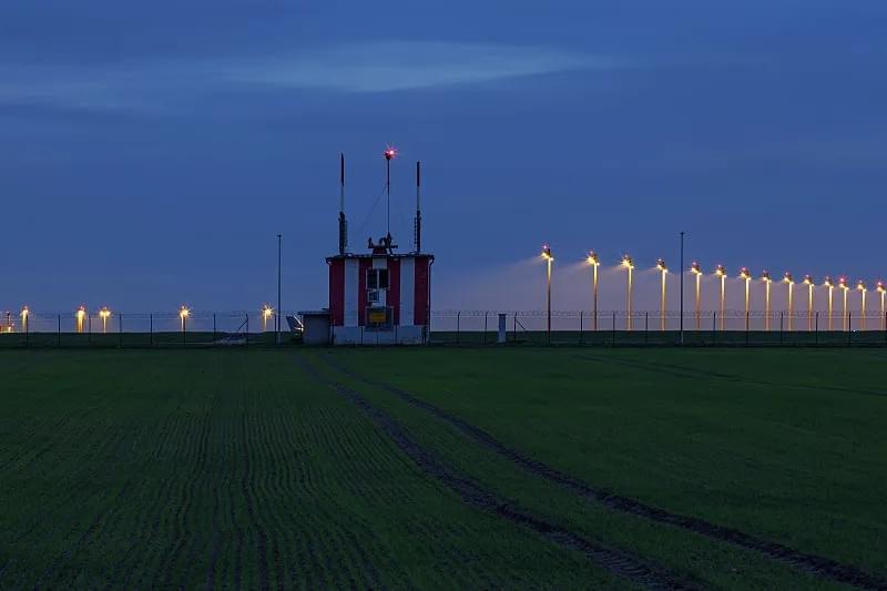
Airport AWOS stands as the unsung hero of modern aviation, delivering precise weather insights that keep flights on track and passengers safe. In an industry where split-second decisions can mean the difference between smooth operations and costly disruptions, this Automated Weather Observing System is more than a tool—it’s a critical infrastructure that bridges meteorological data and aviation safety. From small regional airstrips to bustling international hubs, Airport AWOS has become indispensable, providing continuous, reliable weather updates that pilots, air traffic controllers, and ground crews depend on. Let’s dive into the technology, capabilities, and transformative impact of Airport AWOS, and why it’s the cornerstone of confident flight planning in today’s dynamic skies.

What Is Airport AWOS, and Why Does Aviation Need It?
At its core, Airport AWOS—short for Automated Weather Observing System—is a sophisticated network of sensors, data processors, and communication tools designed to collect, analyze, and distribute real-time weather data at airports. Unlike manual weather observations, which rely on human observers and are prone to delays, inconsistencies, and human error, Airport AWOS operates 24/7 without interruption. It captures a comprehensive range of meteorological parameters critical to aviation: wind speed and direction, ambient temperature, dew point, visibility, cloud height and coverage, atmospheric pressure, and even precipitation type and intensity. For pilots, this data isn’t just informative—it’s actionable. Before takeoff, during flight, and while preparing to land, access to accurate, up-to-the-minute weather conditions allows them to assess risks, adjust flight plans, and make decisions that prioritize safety and efficiency.
The aviation industry’s reliance on Airport AWOS stems from its ability to mitigate the inherent risks of adverse weather. Turbulence, sudden wind shifts, low visibility, and unexpected precipitation are among the top causes of flight delays, diversions, and even accidents. According to aviation safety reports, over 70% of weather-related flight incidents are linked to a lack of real-time, precise weather data. Airport AWOS addresses this gap by delivering consistent, objective observations that eliminate the variability of manual reports. Whether a pilot is navigating a small propeller plane through a regional storm or a commercial airline captain overseeing a transatlantic flight, Airport AWOS ensures they have the same level of detailed weather intelligence—empowering them to avoid hazards and optimize flight paths.
But Airport AWOS isn’t just for pilots. Air traffic controllers use its data to manage airspace flow, ensuring that takeoffs and landings are spaced safely based on current weather conditions. Ground crews rely on it to make decisions about aircraft maintenance, fueling, and loading—for example, delaying outdoor tasks during heavy rain or high winds to prevent equipment damage or personnel injury. Even airport administrators use Airport AWOS data to plan infrastructure improvements, such as upgrading runway lighting for low-visibility conditions or investing in snow-clearing equipment based on historical precipitation data collected by the system. In short, Airport AWOS is a unifying tool that connects every facet of airport operations, all centered on the shared goal of safe, efficient aviation.
The Technology Behind Airport AWOS: Sensors, Processing, and Dissemination
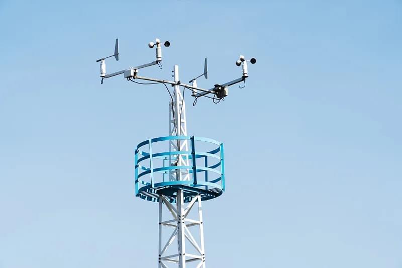
To deliver the reliable data that aviation professionals trust, Airport AWOS relies on a carefully integrated suite of advanced technologies. At the heart of every Airport AWOS system are its sensors—specialized devices designed to measure specific weather parameters with pinpoint accuracy. Let’s take a closer look at the key components that make Airport AWOS tick:
Core Sensors: The Eyes and Ears of Airport AWOS
- Anemometers: These devices measure wind speed and direction, two of the most critical parameters for takeoffs and landings. Airport AWOS uses ultrasonic anemometers, which are more accurate and durable than traditional cup-and-vane models. They can detect wind gusts, sustained speeds, and directional shifts in real time, even in extreme conditions like hurricanes or blizzards.
- Thermometers and Hygrometers: Temperature and humidity (measured via dew point) affect aircraft performance—hotter air is less dense, reducing lift, while high humidity can lead to fog or icing. Airport AWOS uses digital thermometers and hygrometers that provide precise readings to the nearest 0.1°C, ensuring pilots have accurate data to calculate takeoff weights and fuel requirements.
- Visibility Sensors: Low visibility is a major cause of flight delays and cancellations. Airport AWOS uses forward-scatter sensors or transmissometers to measure visibility up to 10 kilometers (or more for larger airports). These sensors emit light and measure how much is scattered or transmitted through the air, providing real-time visibility data that helps pilots determine if landing is safe under Visual Flight Rules (VFR) or Instrument Flight Rules (IFR).
- Ceilometers: Cloud height is another critical factor—pilots need to know how low clouds are to avoid collisions and ensure they can maintain visual contact with the ground (if flying VFR). Airport AWOS ceilometers use laser or infrared technology to measure the height of cloud bases, delivering readings in meters or feet with exceptional precision.
- Barometers: Atmospheric pressure affects weather patterns and aircraft altimeter settings. Airport AWOS barometers measure pressure changes in real time, allowing pilots to adjust their altimeters for accurate altitude readings—critical for avoiding terrain and maintaining safe separation from other aircraft.
- Precipitation Sensors: These sensors detect the type (rain, snow, sleet, hail) and intensity of precipitation. For example, snowfall can reduce runway friction, while hail can damage aircraft surfaces. Airport AWOS precipitation sensors provide data that helps ground crews prepare runways (e.g., applying de-icing fluid) and pilots adjust their approach speeds.
Haisen’s Aviation Automatic Weather Observation Station—an industry-leading Airport AWOS solution—exemplifies how these sensors work in harmony. Its integrated design ensures that data from each sensor is synchronized and processed in real time, eliminating lag and ensuring consistency. The station’s rugged construction is built to withstand extreme temperatures, high winds, and heavy precipitation, making it reliable in even the harshest airport environments.
Data Processing and Dissemination: Getting AWOS Data to Those Who Need It
Collecting data is only half the battle—Airport AWOS must deliver that data quickly and efficiently to pilots, air traffic controllers, and other stakeholders. Here’s how the process works:
- Data Collection: Sensors continuously gather weather data, typically at intervals of 1–5 seconds.
- Processing and Validation: The Airport AWOS central processor cleans and analyzes the data, removing anomalies (e.g., a temporary sensor glitch) and validating readings against historical patterns to ensure accuracy.
- Formatting: The processed data is formatted into standardized aviation codes, such as METAR (Aviation Routine Weather Report) and SPECI (Special Weather Report), which are universally understood by pilots and air traffic controllers worldwide.
- Dissemination: The formatted data is distributed through multiple channels, including:
- Radio Frequencies: Pilots can tune into a dedicated airport frequency to hear AWOS updates via automated voice announcements.
- Flight Service Stations (FSS): FSS personnel relay AWOS data to pilots via phone or radio.
- Avionics Systems: Modern aircraft are equipped with systems that can receive and display AWOS data directly in the cockpit, eliminating the need for manual checks.
- Airport Websites and Mobile Apps: Passengers and ground crews can access AWOS data online or via mobile apps to stay informed about flight conditions.
The speed of dissemination is critical. Airport AWOS systems typically issue updates every minute under normal conditions, and even more frequently (every 15–30 seconds) during rapidly changing weather. This frequency ensures that pilots and controllers always have the latest information—no more relying on outdated reports that could put flights at risk.

How Often Is Airport AWOS Data Issued? The Importance of Timeliness
One of the most common questions aviation professionals ask is: “How often is Airport AWOS issued?” The answer lies in the system’s design philosophy: to provide real-time data that reflects the current weather conditions, not a snapshot from 10 or 15 minutes ago. Under standard operating conditions, Airport AWOS issues weather updates every 60 seconds. This means that pilots checking AWOS data before takeoff or during flight get a near-instantaneous view of wind speed, visibility, cloud height, and other critical parameters.
But what about when weather conditions are changing rapidly—for example, during a thunderstorm, sudden fog, or a wind shear event? In these scenarios, Airport AWOS automatically increases its update frequency to every 15–30 seconds. This rapid reporting ensures that pilots and controllers can respond immediately to changing conditions, adjusting flight plans or diverting aircraft if necessary. For example, if wind speed suddenly spikes from 10 knots to 30 knots, Airport AWOS will detect the change within seconds and issue an updated report, allowing the pilot to abort takeoff or adjust their landing approach to avoid instability.
The timeliness of Airport AWOS data stands in stark contrast to manual weather observations, which are typically conducted only once every hour (or every 30 minutes at larger airports). Manual observations are not only less frequent but also prone to delays—for example, a human observer might be busy with other tasks, or unable to access observation points during severe weather. This gap in data can have serious consequences. Imagine a pilot relying on a manual observation from 45 minutes ago, unaware that visibility has dropped from 10 kilometers to 1 kilometer due to sudden fog. Without real-time Airport AWOS data, the pilot might attempt a landing that’s no longer safe.
Timeliness also plays a key role in operational efficiency. Airlines lose billions of dollars each year due to weather-related delays and cancellations. Airport AWOS helps reduce these losses by providing accurate, up-to-date data that allows airlines to make proactive decisions. For example, if AWOS data shows that a storm is approaching an airport, airlines can adjust departure times or reroute flights before the storm hits, avoiding costly delays and keeping passengers informed.
AWOS vs. ASOS: Which Is Better for Aviation?
When discussing automated weather observing systems, the question often arises: “What’s better, AWOS or ASOS?” To answer this, we first need to understand the differences between the two systems, their design purposes, and their strengths in various aviation scenarios.
Key Differences Between AWOS and ASOS
ASOS—short for Automated Surface Observing System—is another widely used automated weather system, but it differs from Airport AWOS in several key ways:
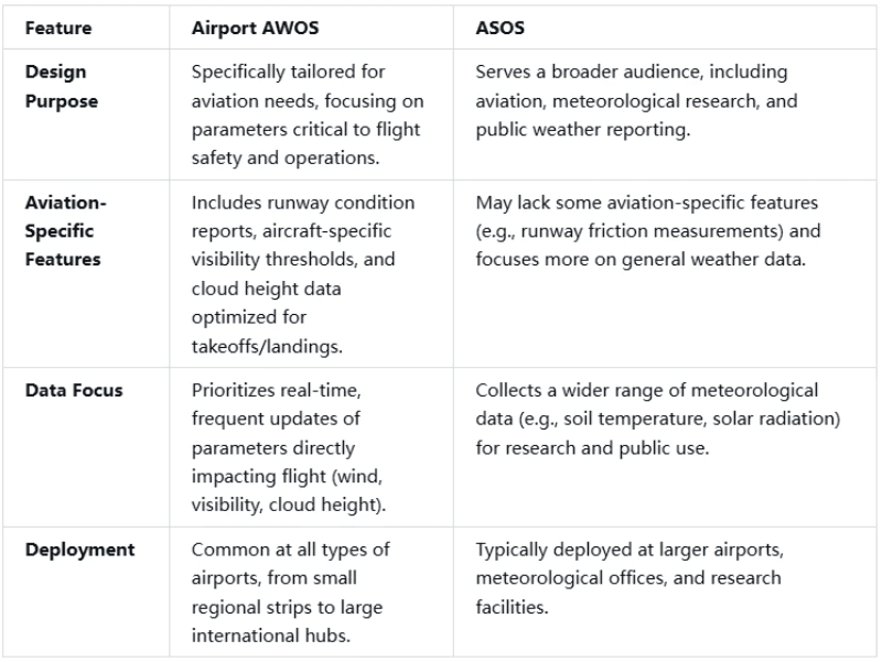
Advantages of Airport AWOS for Aviation
For aviation professionals, Airport AWOS offers several distinct advantages over ASOS:
- Aviation-Centric Data: Airport AWOS is designed from the ground up to meet the unique needs of pilots and air traffic controllers. It prioritizes the parameters that matter most for flight—wind speed and direction, visibility, cloud height, and runway conditions—while minimizing non-essential data. This focus ensures that pilots get the information they need without sifting through irrelevant details.
- Faster Updates: As mentioned earlier, Airport AWOS issues updates every minute (or more frequently during changing weather), while ASOS updates are typically issued every 5–10 minutes. For aviation, where every second counts, this faster update frequency can be a lifesaver.
- Customization: Airport AWOS systems can be customized to meet the specific needs of an airport. For example, a small regional airport might opt for a basic AWOS system (like AWOS 1) that measures core parameters, while a large international hub might choose a more advanced system (like AWOS 2) that includes precipitation type detection and enhanced cloud height measurements.
- Ease of Use: Airport AWOS data is formatted specifically for aviation use, with clear, concise METAR and SPECI codes that pilots are trained to interpret quickly. ASOS data, while accurate, may include additional codes and parameters that are more relevant to meteorologists than pilots.
When Might ASOS Be Preferable?
While Airport AWOS is the ideal choice for most aviation applications, there are scenarios where ASOS might be more suitable:
- Meteorological Research: ASOS collects a wider range of data (e.g., solar radiation, soil moisture) that is valuable for climate research and long-term weather forecasting.
- Public Weather Reporting: ASOS data is often used by national weather services (e.g., NOAA in the U.S.) to provide public weather updates, making it a better choice for airports that need to share data with the general public.
- Large-Scale Environmental Monitoring: Airports located in environmentally sensitive areas (e.g., near national parks or coastal regions) may use ASOS to monitor broader environmental conditions beyond just aviation-related parameters.
In summary, while both systems are valuable, Airport AWOS is the clear choice for aviation operations due to its focus, speed, and customization. It’s designed to keep pilots safe and flights efficient, which is why it’s the preferred system at airports around the world.
AWOS 1 vs. AWOS 2: Choosing the Right System for Your Airport
Not all Airport AWOS systems are created equal. Two of the most common configurations are AWOS 1 and AWOS 2, each designed to meet the needs of different types of airports. Understanding the differences between them is crucial for airport administrators looking to invest in the right weather observation solution.
AWOS 1: Basic Weather Observations for Small Airports
AWOS 1 is the entry-level Airport AWOS system, designed for small regional airports, private airstrips, and general aviation facilities. It focuses on delivering the core weather parameters that pilots need to make safe takeoff and landing decisions, without the advanced features that larger airports require. The key features of AWOS 1 include:
- Core Parameters: Wind speed and direction, temperature, dew point, visibility, and cloud cover (broken, overcast, etc.).
- Update Frequency: Every 60 seconds under normal conditions.
- Simplicity: Easy to install, operate, and maintain, with a lower cost than advanced systems.
- Ideal For: Small airports with low traffic volume, where basic weather data is sufficient for flight operations. For example, a rural airport serving crop dusters, private pilots, and small charter flights would benefit from AWOS 1, as its simple design and reliable data meet their operational needs without unnecessary complexity.
One of the biggest advantages of AWOS 1 is its accessibility. It’s designed to be user-friendly, with automated voice announcements that pilots can access via radio, and a simple interface for ground crews to monitor weather conditions. Its low maintenance requirements make it a cost-effective solution for small airports with limited budgets.
AWOS 2: Advanced Features for Larger Airports
AWOS 2 builds on the foundation of AWOS 1, adding advanced features that meet the needs of larger regional airports, commercial facilities, and airports with higher traffic volume. It provides more comprehensive weather data, allowing pilots and controllers to make more informed decisions in complex operating environments. The key features of AWOS 2 include:
- All AWOS 1 Parameters: Plus additional parameters like atmospheric pressure, precipitation type (rain, snow, sleet), and enhanced cloud height measurements (including multiple cloud layers).
- Advanced Sensors: Equipped with more sophisticated sensors, such as laser ceilometers for precise cloud height readings and precipitation discriminators that distinguish between different types of precipitation.
- Customizable Alerts: Can be configured to send alerts when weather conditions exceed predefined thresholds (e.g., low visibility, high winds), allowing controllers and ground crews to respond proactively.
- Ideal For: Larger airports serving commercial flights, corporate jets, and high-volume general aviation. For example, a regional airport with daily flights to major cities would benefit from AWOS 2, as its advanced data helps pilots navigate complex weather patterns and ensures that flights remain on schedule.
AWOS 2 is also designed to integrate with other airport systems, such as air traffic control software and runway lighting systems. For example, if AWOS 2 detects low visibility, it can automatically trigger the activation of high-intensity runway lights, improving pilot visibility and safety.
Choosing Between AWOS 1 and AWOS 2
The decision between AWOS 1 and AWOS 2 depends on several factors, including:
- Airport Size and Traffic Volume: Smaller airports with low traffic can typically get by with AWOS 1, while larger airports with commercial flights need the advanced features of AWOS 2.
- Operational Complexity: Airports located in areas with frequent weather changes (e.g., coastal regions, mountainous areas) may benefit from AWOS 2’s enhanced precipitation and cloud height data.
- Budget: AWOS 1 is more cost-effective, while AWOS 2 requires a larger upfront investment but delivers greater value for airports with complex operational needs.
Haisen’s Aviation Automatic Weather Observation Station offers both AWOS 1 and AWOS 2 configurations, allowing airport administrators to choose the system that best fits their needs. With modular design, the system can also be upgraded from AWOS 1 to AWOS 2 as the airport grows, providing a scalable solution that adapts to changing operational requirements.
The Benefits of Airport AWOS: Beyond Weather Reporting
Airport AWOS is more than just a weather observation system—it’s a catalyst for safer, more efficient, and more reliable aviation operations. Its benefits extend far beyond providing real-time weather data, impacting every aspect of airport management and flight operations.
Enhancing Flight Safety
The most significant benefit of Airport AWOS is its role in enhancing flight safety. By providing accurate, real-time weather data, it helps pilots avoid hazardous conditions such as low visibility, wind shear, and unexpected precipitation. For example, if Airport AWOS detects a sudden drop in visibility due to fog, pilots can delay takeoff or divert to an alternate airport, preventing potential accidents. Similarly, wind shear—sudden changes in wind speed or direction that can cause aircraft to lose lift—is one of the most dangerous weather phenomena for aviation. Airport AWOS’s real-time wind data allows pilots to detect wind shear early and adjust their approach, reducing the risk of a crash.
Airport AWOS also reduces the risk of human error. Manual weather observations are subject to mistakes—for example, a human observer might misjudge cloud height or wind speed, leading to incorrect reports. Airport AWOS eliminates this variability, providing consistent, objective data that pilots and controllers can trust. This reliability is especially critical in high-stakes situations, where even a small error in weather data can have catastrophic consequences.
Improving Operational Efficiency
In addition to safety, Airport AWOS significantly improves operational efficiency for airlines and airports. Weather-related delays cost the aviation industry billions of dollars each year, with airlines losing revenue due to canceled flights, missed connections, and increased fuel consumption. Airport AWOS helps reduce these delays by providing accurate, timely data that allows airlines to make proactive decisions.
For example, if Airport AWOS predicts that a storm will arrive at an airport in two hours, airlines can adjust departure times to avoid the storm, rather than waiting until the last minute to cancel or delay flights. This not only saves money but also improves passenger satisfaction by reducing unexpected disruptions. Air traffic controllers also benefit from Airport AWOS, as it allows them to manage airspace more efficiently. By knowing the current weather conditions, controllers can space takeoffs and landings to minimize delays and ensure safe separation between aircraft.
Ground operations also become more efficient with Airport AWOS. Ground crews can use the system’s data to plan tasks such as aircraft de-icing, runway cleaning, and fueling. For example, if Airport AWOS detects that snow is expected to fall, ground crews can pre-position snowplows and de-icing equipment, ensuring that runways remain clear and flights can operate on schedule.
Supporting Weather Prediction and Climate Research
Airport AWOS isn’t just useful for real-time flight operations—it also contributes to long-term weather prediction and climate research. The consistent, high-quality data collected by Airport AWOS systems is fed into national and global weather models, helping meteorologists improve the accuracy of forecasts. This is particularly important for predicting severe weather events such as hurricanes, tornadoes, and blizzards, which can have a major impact on aviation and public safety.
Over time, the historical data collected by Airport AWOS also provides valuable insights into climate change. By analyzing trends in temperature, precipitation, and wind patterns, researchers can better understand how the climate is changing and how it will impact aviation in the future. For example, rising temperatures may lead to more frequent heatwaves, which can reduce aircraft performance and require longer runways for takeoffs. Airport AWOS data helps airlines and airports prepare for these changes, ensuring that they can adapt their operations to a changing climate.
Increasing Data Accessibility
Airport AWOS makes weather data more accessible than ever before. Pilots can access data via radio, avionics systems, or mobile apps, allowing them to check weather conditions from anywhere—whether they’re in the cockpit, at the gate, or on the ground. Air traffic controllers have real-time data displayed in their control towers, enabling them to make quick decisions. Even passengers can access Airport AWOS data via airport websites or mobile apps, allowing them to stay informed about flight delays and cancellations.
This accessibility is particularly valuable for general aviation pilots, who often don’t have access to the same resources as commercial airlines. With Airport AWOS, a private pilot can check weather conditions before taking off on a weekend trip, ensuring that they have the information they need to fly safely.

The Future of Airport AWOS: Innovations Shaping Aviation Weather
As technology advances, Airport AWOS is evolving to meet the changing needs of the aviation industry. From improved sensor technology to artificial intelligence (AI) integration, the future of Airport AWOS promises even greater accuracy, reliability, and functionality.
Advanced Sensor Technology
The next generation of Airport AWOS sensors will be more accurate, durable, and versatile than ever before. For example, lidar (light detection and ranging) sensors are being integrated into Airport AWOS systems to provide even more precise measurements of visibility, cloud height, and precipitation. Lidar sensors use laser beams to detect particles in the air, allowing for measurements that are unaffected by fog, rain, or snow. This technology will be particularly valuable for airports located in areas with frequent low-visibility conditions.
Another innovation is the use of multi-parameter sensors that can measure multiple weather parameters with a single device. This reduces the number of sensors needed, lowering installation and maintenance costs while improving data consistency. For example, a single sensor could measure wind speed, temperature, humidity, and atmospheric pressure, eliminating the need for separate devices.
AI and Machine Learning Integration
Artificial intelligence and machine learning are set to revolutionize Airport AWOS. These technologies can analyze vast amounts of weather data to identify patterns and predict future conditions with greater accuracy. For example, AI algorithms can analyze historical Airport AWOS data to predict when fog is likely to form at an airport, allowing pilots and controllers to prepare in advance.
AI can also help improve data validation. By comparing real-time sensor data with historical patterns and data from nearby weather stations, AI algorithms can detect anomalies and correct errors, ensuring that the data provided by Airport AWOS is always accurate. This will be particularly valuable in extreme weather conditions, where sensor glitches are more likely to occur.
IoT Connectivity
The Internet of Things (IoT) is another trend shaping the future of Airport AWOS. IoT-enabled sensors can communicate wirelessly with each other and with the central processor, making installation and maintenance easier. This also allows for remote monitoring of Airport AWOS systems—airport administrators can check the status of sensors and receive alerts about issues from anywhere, reducing downtime and improving reliability.
IoT connectivity also enables integration with other airport systems, such as smart runway lighting, automated de-icing systems, and air traffic control software. For example, if Airport AWOS detects low visibility, it can automatically trigger the activation of smart runway lights that adjust their intensity based on current conditions, improving pilot visibility and safety.
Global Standardization
As aviation becomes more global, there is a growing need for standardized Airport AWOS systems that can be used across different countries and regions. International organizations such as the International Civil Aviation Organization (ICAO) are working to develop global standards for Airport AWOS, ensuring that data is consistent and compatible worldwide. This will make it easier for pilots to fly internationally, as they will be able to rely on the same type of weather data regardless of where they are.
Why Choose Haisen’s Airport AWOS Solutions?
With so many Airport AWOS systems on the market, choosing the right one can be a challenge. Haisen’s Aviation Automatic Weather Observation Station stands out for its reliability, accuracy, and versatility, making it the preferred choice for airports around the world. Here’s why:
- Proven Reliability: Haisen’s Airport AWOS systems are built to withstand extreme weather conditions, from -40°C to 60°C, and are tested to meet international aviation standards. With a mean time between failures (MTBF) of over 10,000 hours, they provide consistent, uninterrupted service.
- Accurate Data: Haisen uses only the highest-quality sensors, including ultrasonic anemometers, laser ceilometers, and forward-scatter visibility sensors, to ensure that data is precise and reliable. The system’s advanced data processing algorithms further enhance accuracy by eliminating anomalies and validating readings.
- Customization: Haisen’s Airport AWOS systems are available in AWOS 1 and AWOS 2 configurations, with modular design that allows for upgrades as needed. Airport administrators can choose the features that best fit their operational needs and budget.
- Easy Integration: Haisen’s systems integrate seamlessly with other airport systems, including air traffic control software, runway lighting, and mobile apps. This ensures that weather data is accessible to everyone who needs it, when they need it.
- Exceptional Support: Haisen provides 24/7 technical support, with a team of aviation weather experts ready to assist with installation, maintenance, and troubleshooting. The company also offers training for airport staff, ensuring that they can make the most of the system’s features.
Whether you’re a small regional airport looking for a basic weather observation solution or a large international hub in need of advanced features, Haisen’s Airport AWOS systems deliver the performance, reliability, and value you need to keep your operations safe and efficient.
Conclusion: Airport AWOS—The Foundation of Safe, Efficient Aviation
In the fast-paced world of aviation, where weather can change in an instant and safety is non-negotiable, Airport AWOS stands as a critical tool that connects meteorological data to real-world flight operations. From its advanced sensors that capture precise weather parameters to its rapid data dissemination that ensures pilots and controllers have the latest information, Airport AWOS is the backbone of modern aviation safety and efficiency.
Whether you’re a pilot relying on real-time wind data to make a safe landing, an air traffic controller managing airspace flow during a storm, or an airport administrator looking to reduce delays and improve operations, Airport AWOS delivers the data you need to make informed decisions. Its ability to operate 24/7 without interruption, eliminate human error, and adapt to changing weather conditions makes it an indispensable asset for any airport.
As technology continues to advance, Airport AWOS will only become more powerful, with innovations like AI integration, IoT connectivity, and advanced sensors pushing the boundaries of what’s possible. Haisen’s Aviation Automatic Weather Observation Station is at the forefront of these innovations, providing airports with reliable, customizable solutions that meet their unique needs.
If you’re looking to enhance flight safety, improve operational efficiency, and ensure that your airport is equipped to handle the challenges of modern aviation, investing in a high-quality Airport AWOS system is the first step. With Haisen’s proven track record of excellence and commitment to innovation, you can trust that your Airport AWOS solution will deliver the performance and reliability you need to keep your flights safe and your operations running smoothly.
Don’t let unpredictable weather put your flights at risk—choose Haisen’s Airport AWOS and take control of your aviation weather data today.