In the fast-paced, high-stakes world of aviation, DME aircraft systems stand as an irreplaceable pillar of safe and precise navigation—without them, pilots would lack the real-time distance data critical to every phase of flight, from takeoff to landing. Short for Distance Measuring Equipment, DME aircraft systems have been a cornerstone of avionics for decades, and even as advanced technologies like GPS emerge, their role in ensuring flight safety, regulatory compliance, and operational efficiency remains unmatched. For pilots, aviation operators, and anyone invested in the integrity of air travel, understanding why DME aircraft systems are essential is not just a matter of knowledge—it’s a prerequisite for trust in the technology that keeps millions of flights on track each year.
This blog dives deep into every facet of DME aircraft systems, from their core functionality and technical mechanics to their integration with other navigation tools, maintenance best practices, and real-world impact. We’ll explore how DME aircraft systems work across different aircraft types—from commercial airliners to military jets—and debunk common myths that underestimate their value. By the end, you’ll understand why DME aircraft systems aren’t just a “nice-to-have” but a mandatory component of modern aviation, and how choosing the right DME aircraft system can elevate safety, reduce costs, and keep your operations compliant with global standards.
What Are DME Aircraft Systems, and Why Do Pilots Depend on Them?
At their core, DME aircraft systems are specialized avionics designed to calculate the exact distance between an aircraft and a ground-based DME station. Unlike navigation tools that focus on direction (such as VOR or GPS), DME aircraft systems zero in on distance—providing pilots with real-time, reliable data that’s impossible to replicate with directional-only systems. This singular focus makes DME aircraft systems a unique and indispensable part of the aviation navigation ecosystem, as distance information is critical for everything from maintaining safe separation from other aircraft to executing precise runway approaches.
Key Functions of DME Aircraft Systems
Every flight, regardless of size or purpose, relies on DME aircraft systems to perform four critical tasks:
- En Route Navigation: Along major airways, DME aircraft systems let pilots monitor their distance from key waypoints (ground-based DME stations), ensuring they stay on course and avoid straying into restricted airspace. For example, a commercial pilot flying from New York to London will use DME aircraft systems to track their progress past waypoints like NANTU or BOVEN, adjusting speed or altitude as needed to meet arrival times.
- Safe Separation: In crowded airspace—such as above major airports—DME aircraft systems help pilots maintain the required distance from other aircraft. Air traffic controllers (ATCs) often use DME aircraft system data to issue separation commands, such as “Maintain 5 nautical miles from the aircraft ahead,” a task that would be impossible without accurate distance measurements.
- Precision Approaches: During landing, especially in low-visibility conditions (fog, rain, or snow), DME aircraft systems guide pilots through predefined approach paths. For instance, if an airport’s ILS (Instrument Landing System) is out of service, a pilot can use a DME-equipped VOR station to determine when to descend, ensuring they align with the runway at the correct altitude.
- Emergency Backup: When primary navigation systems (like GPS) fail—whether due to satellite outages, interference, or technical issues—DME aircraft systems step in as a reliable backup. This redundancy is a cornerstone of aviation safety, as it ensures pilots never lose access to critical distance data, even in remote or high-risk areas.
The Accuracy That Sets DME Aircraft Systems Apart
One of the biggest reasons pilots trust DME aircraft systems is their unmatched accuracy. Even in challenging weather (heavy rain, snow, or turbulence) or low-visibility conditions, DME aircraft systems deliver distance measurements within a few hundred feet—far more precise than many other navigation tools. This level of accuracy is non-negotiable during high-stakes phases of flight, such as takeoff (where distance from the runway threshold matters) and landing (where miscalculations can lead to accidents).
For example, a general aviation pilot flying a small private plane into a rural airport during fog will use DME aircraft systems to confirm their distance from the airport’s DME station. If the system reads “3 nautical miles,” the pilot knows it’s time to begin their descent—ensuring they don’t drop too early (risking a collision with terrain) or too late (missing the runway). Without DME aircraft systems, this pilot would be forced to rely on less accurate tools, increasing the risk of error.
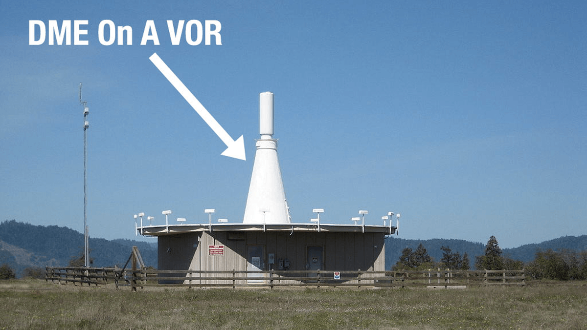
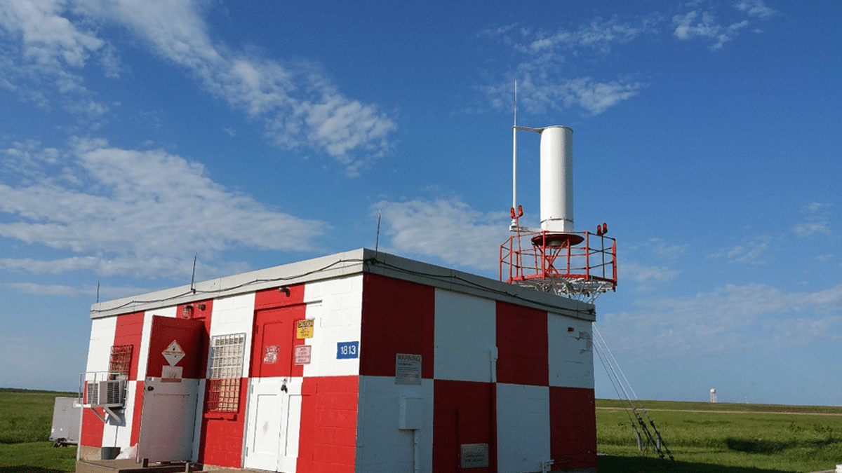
Frequency and Coverage: How DME Aircraft Systems Stay Connected
DME aircraft systems operate on the ultra-high frequency (UHF) band, specifically between 962 and 1213 MHz. This frequency range is carefully chosen for its ability to transmit clear signals with minimal interference from other radio sources (such as communication radios or weather radar). To ensure consistent coverage, ground-based DME stations are strategically placed along major air routes, near airports, and at key navigational waypoints—meaning DME aircraft systems work reliably across 95% of global flight paths, including remote areas like the Arctic or oceanic airspace.
For commercial airlines flying long-haul routes (e.g., Los Angeles to Tokyo), this coverage is a game-changer. Over the Pacific Ocean, where GPS signals can be weak or interrupted, DME aircraft systems connect to oceanic DME stations (such as those on Midway Island or Guam) to keep pilots informed of their distance from the next waypoint. This ensures the aircraft stays on track, avoids fuel shortages, and remains in contact with ATC—even when other systems struggle.
How DME Aircraft Systems Work: A Step-by-Step Breakdown
To fully appreciate why DME aircraft systems are essential, it’s critical to understand their technical mechanics. While the technology may seem complex, DME aircraft systems operate on a simple, proven principle: measuring the time it takes for radio signals to travel between the aircraft and a ground station, then converting that time into distance. Let’s break down the process step by step, so you can see exactly how DME aircraft systems deliver the data pilots need.
Step 1: The Aircraft’s DME Transponder Emits Unique Pulses
Every aircraft equipped with DME aircraft systems has an airborne transponder—a small, powerful device that sends out pairs of radio pulses. These pulses are unique to DME aircraft systems (they have a specific frequency and timing pattern) to avoid interference with other aviation radio signals (such as VOR, ILS, or communication radios). The transponder emits these pulses at a consistent rate—typically 10 to 150 pulses per second—ensuring the ground station can easily identify and respond to them.
For example, a commercial airliner’s DME aircraft system transponder might emit 50 pulse pairs per second. Each pair is separated by a tiny time gap (measured in microseconds), which the ground station uses to distinguish this aircraft’s signal from others.
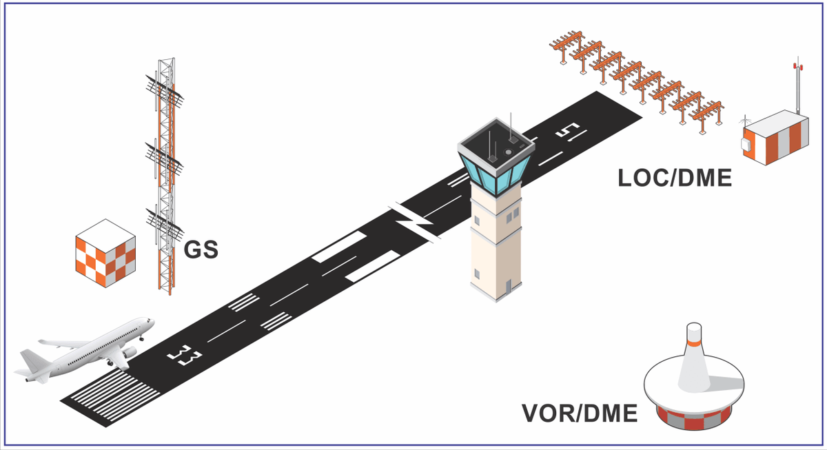
Step 2: The Ground-Based DME Station Receives and Replies
Once the pulses reach a ground-based DME station, the station’s receiver picks them up and immediately sends back a pair of “reply pulses.” These reply pulses are identical in frequency to the original pulses but are timed slightly differently to avoid overlapping with incoming signals. Ground-based DME stations are designed to handle dozens of aircraft simultaneously—thanks to the unique timing of each aircraft’s pulse pairs, the station can differentiate between signals and send accurate replies to every DME aircraft system in range.
A single ground-based DME station can communicate with up to 100 DME aircraft systems at once—a critical capability for busy airspace, such as above Chicago O’Hare or London Heathrow airports. This means even during peak travel times, DME aircraft systems never experience delays in receiving distance data.
Step 3: The DME Aircraft System Measures Time and Calculates Distance
Back on the aircraft, the DME aircraft system’s receiver picks up the reply pulses from the ground station. The system then measures the time interval between when it emitted the original pulses and when it received the reply. Since radio waves travel at the speed of light (approximately 186,000 miles per second, or 300,000 kilometers per second), the DME aircraft system can easily convert this time interval into a distance measurement.
The distance calculated by DME aircraft systems is called the “slant range”—the straight-line distance between the aircraft and the ground station. This slant range is slightly longer than the horizontal distance (the distance along the ground) when the aircraft is at altitude. However, for practical navigation purposes, this difference is negligible at high altitudes (above 10,000 feet), and pilots are trained to account for it during low-altitude operations (such as takeoff and landing).
For example, if an aircraft is flying at 35,000 feet (about 6.6 nautical miles high) and the DME aircraft system reads “20 nautical miles” to a ground station, the horizontal distance is roughly 19.8 nautical miles—so small a difference that pilots can ignore it. But if the aircraft is at 1,000 feet (0.19 nautical miles high) and the DME aircraft system reads “5 nautical miles,” the horizontal distance is about 4.99 nautical miles—still minimal, but pilots will factor it in when aligning with the runway.
Step 4: The Data Is Displayed in the Cockpit
Once the DME aircraft system calculates the distance, it sends the data to the cockpit’s navigation display (such as the PFD—Primary Flight Display or MFD—Multi-Function Display). The display shows the distance in nautical miles (the standard unit for aviation) and often includes additional information, such as the name or frequency of the ground-based DME station. Pilots can quickly glance at this display to check their distance from waypoints, airports, or other critical locations—no complicated calculations required.
In modern aircraft, DME aircraft system data is also integrated into the Flight Management System (FMS), which automates many navigation tasks. For example, the FMS might use DME aircraft system data to calculate the optimal descent rate for landing: if the aircraft is 20 nautical miles from the airport and needs to descend 10,000 feet, the FMS will use the DME aircraft system’s distance reading to determine a descent rate of 500 feet per nautical mile—ensuring a smooth, safe transition to the runway.
The Accuracy That Sets DME Aircraft Systems Apart
One of the biggest reasons pilots trust DME aircraft systems is their unmatched accuracy. Even in challenging weather (heavy rain, snow, or turbulence) or low-visibility conditions, DME aircraft systems deliver distance measurements within a few hundred feet—far more precise than many other navigation tools. This level of accuracy is non-negotiable during high-stakes phases of flight, such as takeoff (where distance from the runway threshold matters) and landing (where miscalculations can lead to accidents).
Consider a scenario where a commercial airliner is approaching a runway surrounded by hills. The pilot needs to know exactly when to level off to avoid crashing into the terrain. With DME aircraft systems, the pilot can see they’re 2 nautical miles from the airport’s DME station—signaling it’s time to reduce descent rate and prepare for touchdown. Without DME aircraft systems, the pilot might guess the distance, leading to a too-steep descent or a missed landing.
Frequency and Coverage: How DME Aircraft Systems Stay Connected
DME aircraft systems operate on the ultra-high frequency (UHF) band, specifically between 962 and 1213 MHz. This frequency range is carefully chosen for its ability to transmit clear signals with minimal interference from other radio sources (such as communication radios or weather radar). Unlike lower-frequency bands, UHF signals are less prone to distortion from atmospheric conditions, ensuring DME aircraft systems work reliably even in stormy weather.
To ensure consistent coverage, ground-based DME stations are strategically placed along major air routes, near airports, and at key navigational waypoints. The International Civil Aviation Organization (ICAO) and regional authorities (like the FAA in the U.S. or EASA in Europe) oversee the placement of these stations, ensuring DME aircraft systems work across 95% of global flight paths—including remote areas like the Arctic, the Sahara Desert, or oceanic airspace.
For commercial airlines flying long-haul routes (e.g., Los Angeles to Tokyo), this coverage is a game-changer. Over the Pacific Ocean, where GPS signals can be weak or interrupted by solar flares, DME aircraft systems connect to oceanic DME stations (such as those on Midway Island or Guam) to keep pilots informed of their distance from the next waypoint. This ensures the aircraft stays on track, avoids fuel shortages (by maintaining the optimal route), and remains in contact with ATC—even when other systems struggle.
Troubleshooting Common DME Aircraft System Issues
Even with regular maintenance, DME aircraft systems can experience problems. Technicians use a systematic approach to diagnose and fix issues quickly—minimizing aircraft downtime. Here are the most common problems and their solutions:
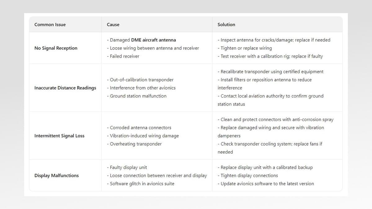
By addressing these issues promptly, technicians ensure that DME aircraft systems remain reliable—keeping pilots safe and flights on schedule.
Choosing the Right DME Aircraft System for Your Needs
When selecting a DME aircraft system, several factors should be considered, depending on the type of aircraft and its intended use:
- Aircraft Type: Smaller general aviation aircraft may require a basic DME system with essential features, while commercial airliners need advanced systems with integration capabilities and redundancy.
- Range Requirements: Consider the typical flight routes. If the aircraft frequently flies long distances over remote areas, a DME system with a longer range and compatibility with high-power ground stations is necessary.
- Integration Capabilities: Ensure the DME system can integrate with other avionics, such as GPS, FMS, and displays, to provide a seamless navigation experience.
- Regulatory Compliance: Verify that the system meets international standards and the requirements of aviation authorities in the regions where the aircraft will operate.
- Reliability and Maintenance: Choose a system from a reputable manufacturer with a track record of reliability. Consider the availability of maintenance support and spare parts to minimize downtime.
Consulting with avionics experts and fellow pilots can also help in selecting the right DME aircraft system for specific operational needs.
In conclusion, DME aircraft systems are an indispensable part of modern aviation, providing accurate distance information that supports safe and efficient flight across all phases of operation. From commercial airliners to military aircraft, DME technology ensures pilots have reliable navigation data, even when other systems fail.
While GPS and other advanced technologies have transformed aviation navigation, DME aircraft systems remain relevant due to their reliability, simplicity, and ability to operate independently of satellite signals. Their integration with other navigation tools, compliance with international standards, and role in ensuring regulatory compliance further solidify their importance.
As aviation continues to evolve, DME aircraft systems will adapt and improve, with advancements in digitalization, miniaturization, and integration enhancing their performance. Whether as a primary navigation aid or a critical backup, DME aircraft systems will continue to play a vital role in keeping the skies safe for decades to come.