In the vast expanse of the aviation realm, where every flight is a calculated dance between man, machine, and nature, AWOS (Automated Weather Observing System) and ASOS (Automated Surface Observing System) emerge as the sentinels of real-time weather data. These two stalwarts, along with the ATIS (Automatic Terminal Information Service), form an intricate web of information that is not merely beneficial but absolutely indispensable for the safe and efficient conduct of air travel. Pilots, air traffic controllers, and airport operators alike rely on these systems to make informed decisions at every stage of a flight, from the pre-flight planning phase to the critical moments of takeoff, landing, and everything in between.
The Crucial Need for Accurate Weather Data in Aviation
Weather is the wild card in aviation, capable of transforming a routine flight into a high-stakes challenge in an instant. A sudden drop in visibility can turn a clear runway into a treacherous landing strip, while gusty crosswinds can test the skills of even the most seasoned pilots. In fact, the Federal Aviation Administration (FAA) has reported that weather-related incidents account for a significant portion of general aviation accidents, highlighting the critical importance of having access to accurate, up-to-date weather information.
The Domino Effect of Inaccurate Weather Data
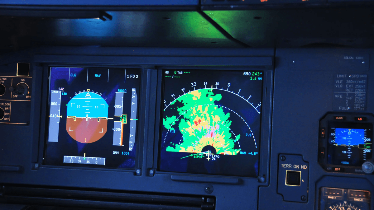
Consider a scenario where a pilot is preparing for a landing at a small airport. Relying on outdated or inaccurate weather data from a less-than-reliable source, the pilot believes the visibility is sufficient and the winds are calm. However, as the aircraft approaches the runway, a sudden fog bank rolls in, reducing visibility to near zero, and strong crosswinds start buffeting the plane. Without the timely and accurate data that AWOS, ASOS, or ATIS can provide, the pilot may be forced to make split-second decisions that could put the lives of passengers and crew at risk. This is not a far-fetched scenario but a real and present danger in the world of aviation, underscoring the vital role these weather reporting systems play.
How AWOS, ASOS, and ATIS Collaborate for Seamless Operations
AWOS, ASOS, and ATIS may seem like distinct entities, but they work in harmony to create a comprehensive weather reporting ecosystem. AWOS and ASOS are the frontline data collectors, using an array of sophisticated sensors to measure a wide range of atmospheric parameters such as wind speed and direction, temperature, humidity, visibility, cloud height, and precipitation. These measurements are then relayed in real-time, providing a constantly updated snapshot of the weather conditions on the ground.
ATIS, on the other hand, acts as the information aggregator and disseminator. It takes the raw data from AWOS and ASOS, along with other relevant information such as runway status, NOTAMs (Notice to Air Missions), and airport advisories, and packages it into pre-recorded, easy-to-understand broadcasts. Pilots can tune in to the ATIS frequency before takeoff or landing to get a complete overview of the conditions at their destination airport, reducing the need for time-consuming radio communication with air traffic controllers and ensuring that everyone is on the same page.
Decoding AWOS: The Basics and Beyond
AWOS is a fundamental component of the aviation weather reporting infrastructure, especially at smaller, uncontrolled airports where human weather observers may not be present. These automated systems are designed to provide pilots with essential weather information, allowing them to make informed decisions about whether to proceed with a flight or seek an alternate route.
The Inner Workings of AWOS
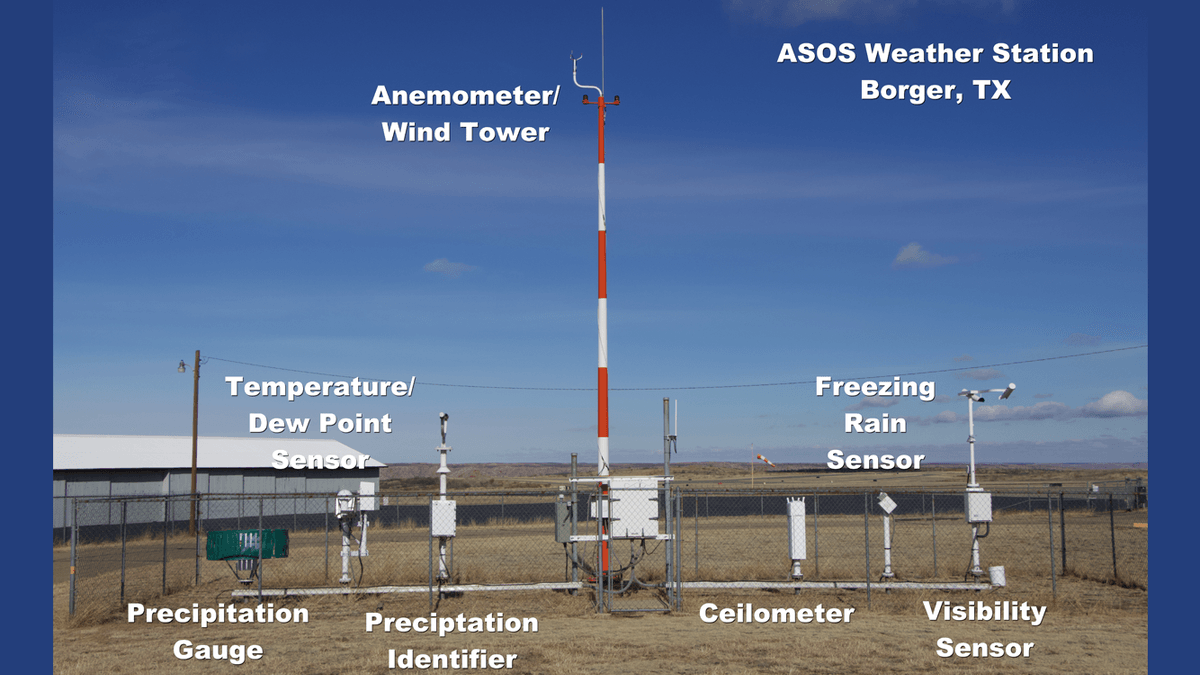
AWOS stations are equipped with a variety of sensors that continuously monitor the local weather conditions. These sensors can measure wind speed and direction, temperature, dew point, altimeter setting, and in some cases, visibility and cloud height. The data collected by these sensors is processed by a computer system, which then generates a voice broadcast that is transmitted over a specific radio frequency. Pilots in the vicinity of the airport can tune in to this frequency to hear the latest weather report, which is typically updated every minute.
Different Levels of AWOS Capabilities
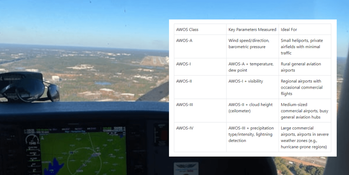
There are several different levels of AWOS capabilities, each offering a different set of weather parameters. The most basic level, AWOS - A, can only report the altimeter setting. As the capabilities increase, so does the amount of information provided. AWOS - 1 can report wind speed, direction, temperature, dew point, and density altitude. AWOS - 2 adds visibility to the mix, while AWOS - 3 includes cloud height and ceiling information. More advanced versions, such as AWOS - 3P/T, can also identify precipitation type and detect lightning strikes, providing pilots with a more comprehensive understanding of the weather conditions.
The Role of AWOS in Small Airport Operations
For small, uncontrolled airports, AWOS is often the primary source of weather information. Pilots relying on these airports for takeoff, landing, or refueling can quickly access the latest weather data, allowing them to assess the safety of their operations. In remote areas where access to other weather reporting systems may be limited, AWOS provides a crucial lifeline, ensuring that pilots are not flying blind. For example, a small charter plane operating in a rural area may rely solely on the AWOS at the local airport to determine if it's safe to continue its journey.
ASOS: A Step Up in Weather Monitoring Sophistication
ASOS represents a more advanced and comprehensive approach to automated weather monitoring compared to AWOS. Operated jointly by the National Weather Service (NWS), the Federal Aviation Administration (FAA), and the Department of Defense (DOD), ASOS serves as the nation's primary surface weather observing network, playing a pivotal role in both aviation operations and weather forecasting.
ASOS Sensor Array and Data Collection
ASOS stations are equipped with an extensive array of sensors that can measure a wide range of weather parameters with high precision. In addition to the basic parameters measured by AWOS, such as wind, temperature, and visibility, ASOS can also provide detailed information about cloud layers, precipitation intensity and type (including rain, snow, sleet, and hail), barometric pressure trends, and even the presence of fog or other obscurations. These sensors are strategically placed around the airport to ensure that the data collected is representative of the conditions on the runway and in the surrounding area.
Real - Time Updates and Wide - Spread Dissemination
One of the key advantages of ASOS is its ability to provide real-time updates. The system is designed to update its observations every minute, 24 hours a day, 365 days a year. This continuous stream of data is not only invaluable for pilots in the air but also for meteorologists on the ground who use it to create accurate weather forecasts. The data collected by ASOS is disseminated through multiple channels, including radio frequencies, the internet, and phone recordings, making it easily accessible to a wide range of users, from commercial airline pilots to private aviators to weather enthusiasts.
ASOS's Impact on Aviation and Weather Forecasting
In the aviation world, ASOS data is used for a variety of purposes. Pilots rely on it to plan their flights, make decisions about takeoff and landing, and adjust their routes in response to changing weather conditions. Air traffic controllers use ASOS data to manage air traffic safely and efficiently, ensuring that aircraft are separated by appropriate distances and that landing and takeoff schedules are adjusted as needed. In the realm of weather forecasting, ASOS data is a goldmine. Meteorologists use it to analyze current weather patterns, detect the development of storms, and make more accurate predictions about future weather conditions. For example, during the approach of a hurricane, ASOS stations along the coast can provide crucial data about wind speeds, storm surge levels, and precipitation amounts, helping forecasters issue timely warnings and evacuation orders.
ATIS: The Information Hub for Airport Operations
ATIS is the go - to source for pilots when it comes to getting a comprehensive overview of the conditions at an airport. While AWOS and ASOS focus primarily on weather data, ATIS goes a step further by combining weather information with other essential details about airport operations.
What ATIS Broadcasts
ATIS broadcasts typically include the airport name, a phonetic letter code (which changes with each update to indicate the currency of the information), the time of the latest weather sequence, and a detailed weather report. This weather report includes information on wind direction and velocity, visibility, cloud cover, temperature, dew point, altimeter setting, and any relevant weather advisories. In addition to the weather, ATIS also provides information about active runways, runway conditions (such as wet or icy surfaces), taxiway closures, and any NOTAMs that may affect the operation of the aircraft. For example, a pilot tuning in to the ATIS at a busy international airport may hear that Runway 27L is the active runway, the wind is from 220 degrees at 15 knots, visibility is 5 miles in haze, and there is a NOTAM regarding construction on Taxiway Charlie.

The Importance of ATIS in High - Activity Terminal Areas
In high - activity terminal areas, where multiple aircraft are taking off, landing, and taxiing simultaneously, clear and concise communication is essential. ATIS helps to reduce radio frequency congestion by providing pilots with pre - recorded information that they can access at their convenience. Instead of having to rely on air traffic controllers for every piece of information, pilots can quickly tune in to the ATIS frequency and get a complete picture of the conditions at the airport. This not only saves time but also allows air traffic controllers to focus on their primary task of guiding aircraft safely through the airspace. For example, at an airport like Chicago O'Hare, which handles thousands of flights per day, ATIS plays a crucial role in ensuring that pilots have the information they need to operate efficiently and safely.
How Pilots Use ATIS Information
Pilots typically tune in to the ATIS frequency well in advance of their arrival at an airport. They use the information provided to plan their approach, select the appropriate runway, and make any necessary adjustments to their flight plan. For example, if the ATIS report indicates strong crosswinds on a particular runway, a pilot may choose to use an alternate runway or adjust their approach speed and configuration to compensate for the wind. ATIS information is also used during the pre - flight planning phase, allowing pilots to assess the overall feasibility of a flight based on the weather and airport conditions at their destination.
Comparing AWOS, ASOS, and ATIS: Key Differences and Similarities
While AWOS, ASOS, and ATIS all play important roles in aviation weather reporting, they have distinct differences in terms of their capabilities, coverage, and the type of information they provide. Understanding these differences is crucial for pilots and other aviation professionals to make the most of these systems.
Update Frequency
AWOS and ASOS are designed to provide real - time updates, with most stations updating their weather reports every minute. This makes them ideal for pilots who need the most current information about changing weather conditions. In contrast, ATIS broadcasts are typically updated hourly, although they may be updated more frequently in the event of significant weather or operational changes. Pilots using ATIS need to pay attention to the phonetic letter code to ensure they are using the most recent broadcast.
Comprehensiveness of Information
ATIS is the most comprehensive of the three systems, as it combines weather information with details about airport operations. It provides a complete picture of the conditions at an airport, including runway status, taxiway closures, and NOTAMs. ASOS offers a wide range of weather data, including detailed information about cloud layers, precipitation type and intensity, and barometric pressure trends. AWOS, while providing essential weather information, is generally less comprehensive than ASOS, especially at the lower levels of capability. For example, a basic AWOS may only provide wind, temperature, and altimeter readings, while an ASOS station will provide a much more detailed and nuanced view of the weather.
Coverage and Applicability
ASOS has a wider coverage area compared to AWOS, with stations located at many major airports and some smaller ones as well. It is the primary surface weather observing network in the United States and is used by both the aviation community and meteorologists for weather forecasting. AWOS is more commonly found at smaller, uncontrolled airports, where it serves as a vital source of weather information for pilots operating in these areas. ATIS is mainly available at airports with a control tower, as it is closely tied to airport operations and air traffic control.
Similarities in Function
Despite their differences, AWOS, ASOS, and ATIS all serve the common goal of providing accurate and timely information to support safe aviation operations. They all rely on sensors and automated systems to collect and transmit data, and they all play a crucial role in helping pilots make informed decisions about flight planning, takeoff, landing, and in - flight operations.
Real - World Applications and Case Studies
To truly understand the importance of AWOS, ASOS, and ATIS, it's helpful to look at some real - world examples of how these systems have been used in actual aviation scenarios.
Case Study 1: AWOS Saves the Day at a Small Airport
A small private aircraft was en route to a rural airport with only an AWOS system for weather information. As the pilot approached the airport, the AWOS reported a sudden increase in wind speed and a shift in wind direction, along with a drop in visibility due to a passing rain shower. The pilot, relying on this real - time AWOS data, was able to adjust their approach speed and configuration, ensuring a safe landing despite the challenging weather conditions. Without the AWOS, the pilot may have been caught off - guard by the changing weather and faced a much more difficult and potentially dangerous landing.
Case Study 2: ASOS Guides a Commercial Airliner Through a Storm
A large commercial airliner was flying towards a major airport during a severe thunderstorm. The ASOS at the airport was providing continuous updates on wind shear, precipitation intensity, and lightning activity. The pilots, using this detailed ASOS data, were able to make informed decisions about their approach. They adjusted their altitude and speed to avoid areas of strong wind shear and turbulence, and they timed their landing to coincide with a brief lull in the precipitation. Thanks to the accurate and timely information provided by the ASOS, the flight was able to land safely, minimizing the risk to passengers and crew.
Case Study 3: ATIS Ensures Smooth Operations at a Busy Airport
At a busy international airport, the ATIS was providing up - to - date information on runway closures due to maintenance, changes in the active runway, and current weather conditions. Pilots approaching the airport were able to tune in to the ATIS and plan their approaches accordingly. This helped to reduce congestion on the runway and taxiways, as pilots were already aware of the operational changes before they arrived. The ATIS also provided information about weather advisories, such as low - level wind shear warnings, allowing pilots to take appropriate precautions during their landing. As a result, the airport was able to maintain a high level of operational efficiency, even during a period of increased traffic and challenging weather.
The Future of AWOS, ASOS, and ATIS
As technology continues to advance, so too will the capabilities of AWOS, ASOS, and ATIS. The aviation industry is constantly looking for ways to improve the accuracy, reliability, and accessibility of weather information, and these systems are at the forefront of these efforts.

Technological Advancements on the Horizon
One of the key areas of development is in sensor technology. New sensors are being developed that can measure weather parameters with even greater precision and reliability. For example, researchers are working on sensors that can detect very fine particles in the air, which can be used to provide more accurate visibility readings, especially in conditions such as fog or haze. Additionally, advancements in data processing and communication technologies will allow for faster and more efficient dissemination of weather information. This could lead to real - time updates being available not only to pilots but also to other stakeholders in the aviation industry, such as airport operators and air traffic controllers.
Integration with Other Aviation Systems
In the future, AWOS, ASOS, and ATIS are likely to be more tightly integrated with other aviation systems. For example, they could be integrated with flight management systems (FMS) in aircraft, allowing pilots to receive weather and airport information directly on their cockpit displays. This would eliminate the need for pilots to manually tune in to radio frequencies to access this information, making the process more seamless and efficient. There may also be increased integration with air traffic control systems, allowing for more automated decision - making based on real - time weather data. For example, air traffic controllers could use ASOS data to automatically adjust runway assignments based on wind conditions, reducing the need for manual intervention.
Meeting the Challenges of a Growing Aviation Industry
As the aviation industry continues to grow, the demand for accurate and timely weather information will only increase. AWOS, ASOS, and ATIS will need to evolve to meet these challenges. This may involve expanding the coverage area of these systems, especially in remote or under - served regions. It may also require improving the ability of these systems to handle complex weather scenarios, such as severe storms or volcanic ash clouds. By staying at the forefront of technological innovation, these systems will continue to play a crucial role in ensuring the safety and efficiency of air travel for years to come.
Conclusion: The Indispensable Trio in Aviation
In the complex and ever - changing world of aviation, AWOS, ASOS, and ATIS stand as the cornerstone of weather intelligence. These systems, each with its unique capabilities and functions, work in unison to provide pilots, air traffic controllers, and airport operators with the information they need to make informed decisions and ensure the safe and efficient operation of aircraft. Whether it's a small private plane landing at a rural airport relying on AWOS, a commercial airliner navigating through a storm using ASOS data, or a pilot approaching a busy international airport guided by ATIS information, these systems are the unsung heroes that keep the skies safe. As technology continues to advance and the aviation industry evolves, the importance of AWOS, ASOS, and ATIS will only grow, solidifying their place as an essential part of modern aviation infrastructure.