DME Aircraft Systems are the unsung heroes of aviation navigation, providing pilots with precise distance data that underpins safe, efficient flight operations—from takeoff to landing. In an industry where even small errors in positioning can lead to catastrophic outcomes, these systems act as a reliable anchor, delivering real-time distance measurements between an aircraft and ground-based stations. Whether navigating through crowded airspace, executing instrument approaches in low visibility, or serving as a backup when GPS fails, DME Aircraft Systems are non-negotiable for modern aviation. This guide breaks down their functionality, benefits, integration with other tools, and why they remain indispensable for pilots worldwide—plus how Haisen’s solutions enhance their performance.
1. Introduction: The Critical Role of DME Aircraft Systems in Aviation
Every pilot knows that navigation is about more than just finding a destination—it’s about maintaining situational awareness, complying with regulations, and ensuring the safety of everyone on board. DME Aircraft Systems, short for Distance Measuring Equipment, address this by focusing on one core, life-saving task: calculating the exact distance between an aircraft and a ground-based DME station. Unlike GPS (which relies on satellite signals) or VOR (which provides directional data), DME Aircraft Systems specialize in distance—filling a unique gap in the aviation navigation ecosystem.
Today, DME Aircraft Systems are integrated into nearly every aircraft, from small private planes to large commercial airliners and military jets. They work 24/7, even in harsh weather or remote areas, and serve as a critical backup when primary systems fail. For pilots, this means confidence: whether flying through fog, over mountainous terrain, or across oceans, DME Aircraft Systems ensure they always know their distance to key waypoints. For airport operators and air traffic controllers (ATCs), they enable efficient air traffic flow, reducing congestion and delays.
2. What Are DME Aircraft Systems? A Fundamental Breakdown
To understand why DME Aircraft Systems are essential, you first need to grasp their core purpose, functionality, and design. Let’s start with the basics.
2.1 Definition of DME Aircraft Systems
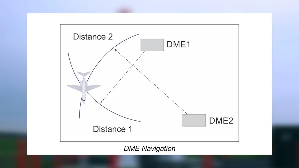
DME Aircraft Systems are specialized avionics that measure the slant range distance (straight-line distance, accounting for altitude) between an aircraft and a ground-based DME station. They operate on ultra-high frequency (UHF) bands (962–1213 MHz)—a range chosen for clear signal transmission with minimal interference from other radio sources.
The system works through a simple yet precise process:
- The aircraft’s DME transponder sends a unique pair of radio pulses to a ground station.
- The ground station receives the pulses and immediately transmits a reply pair back to the aircraft.
- The DME system measures the time it takes for the signal to travel to the station and return (known as “time of flight”).
- Since radio waves travel at the speed of light (186,000 miles per second), the system converts this time into a distance reading, displayed in nautical miles (NM) on the cockpit instrument panel.
This slant range distance is slightly longer than the horizontal distance when the aircraft is at altitude, but pilots are trained to account for this difference—especially during low-altitude operations like approaches and departures.
2.2 Core Purpose of DME Aircraft Systems
The primary goal of DME Aircraft Systems is to provide pilots with real-time, reliable distance information for:
- Navigating along established airways (e.g., staying on course between waypoints).
- Maintaining safe separation from other aircraft (critical in crowded airspace like near major airports).
- Executing precise instrument approaches (e.g., determining when to descend during landing in low visibility).
- Verifying position during takeoff and climb (ensuring the aircraft is on the correct path away from terrain).
Unlike directional systems (e.g., VOR), DME Aircraft Systems focus solely on distance—making them a unique and complementary tool. When paired with VOR (creating “VOR/DME”), they provide both distance and direction, enabling pilots to pinpoint their position with exceptional accuracy.
2.3 Key Advantages of DME Aircraft Systems
What sets DME Aircraft Systems apart from other navigation tools? Here are their most critical benefits:
- Unmatched Accuracy: DME systems typically measure distance within ±0.25 NM or 3% of the total distance (whichever is greater)—far more precise than many backup systems. This accuracy is vital for instrument flight rules (IFR) operations, where visual references are unavailable.
- Reliability in Adverse Conditions: Unlike GPS (which can be disrupted by interference or satellite outages), DME relies on ground-based stations. It works in fog, rain, snow, and remote areas where satellite signals may be weak or nonexistent.
- Simultaneous Multi-Aircraft Support: A single ground-based DME station can communicate with dozens of aircraft at once. Each aircraft’s transponder sends pulses at a unique rate, so the station can differentiate between them—ensuring accurate readings for everyone.
- Easy Integration: DME Aircraft Systems seamlessly connect with other avionics, including VOR, GPS, RNAV (Area Navigation), and flight management systems (FMS). This integration creates a comprehensive navigation suite that reduces pilot workload.
3. How DME Aircraft Systems Work: Step-by-Step
To fully appreciate DME Aircraft Systems, let’s break down their operation into simple, actionable steps. This process happens in real time, without any manual input from the pilot—ensuring constant, reliable data.
3.1 Step 1: Signal Transmission from the Aircraft
The airborne DME equipment (located in the aircraft’s avionics bay) emits a pair of radio pulses. These pulses are:
- Unique to DME: Designed to avoid interference with other aviation radio signals (e.g., communication radios or VOR).
- Timed Precisely: Sent at a specific rate (e.g., 10–150 pulse pairs per second) that the ground station can recognize and track.
The pulses travel outward from the aircraft’s DME antenna (mounted on the fuselage or tail) at the speed of light, heading toward the selected ground-based DME station.
3.2 Step 2: Signal Reception and Reply from the Ground Station
Ground-based DME stations are strategically located along major air routes, near airports, and at key waypoints. When a station receives the aircraft’s pulse pair:
- It immediately generates a reply pulse pair (with a slight delay to avoid overlapping with the original signal).
- The reply pulses are transmitted back to the aircraft using the same UHF frequency band.
These stations are designed to handle high traffic volumes—even during peak hours at busy airports—ensuring no aircraft is left without distance data.
3.3 Step 3: Time Measurement and Distance Calculation
Back in the aircraft, the DME system measures the time interval between sending the original pulses and receiving the reply. This interval is typically just a few milliseconds (even for long distances).
Using the speed of light (186,000 miles per second), the system calculates the total distance the signal traveled (to the station and back). It then divides this distance by 2 to get the slant range (distance from the aircraft to the station).
For example:
- If the time interval is 0.001 seconds, the total signal distance is 186 miles (186,000 miles/second × 0.001 seconds).
- The slant range is 93 miles (186 miles ÷ 2).
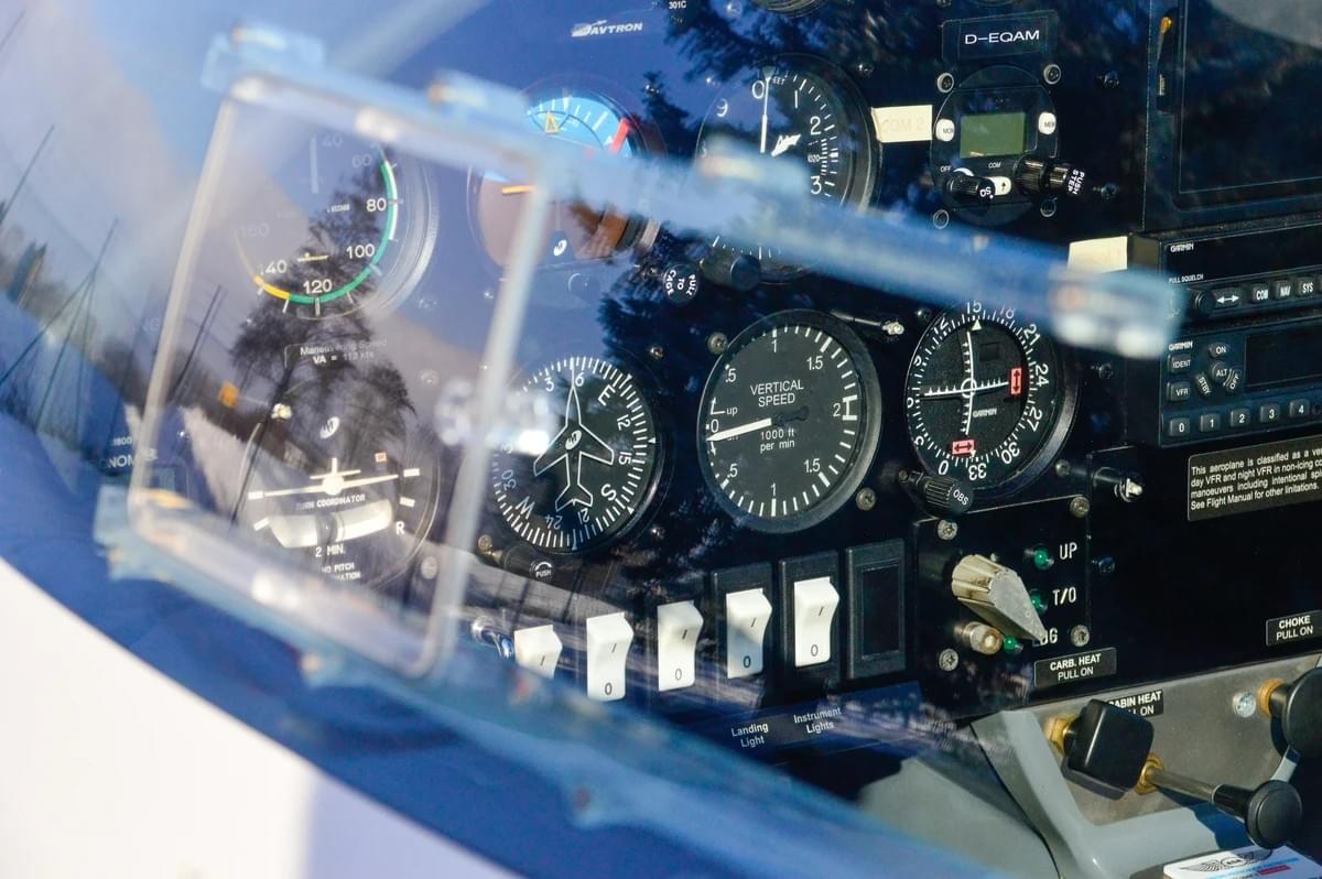
3.4 Step 4: Data Display for the Pilot
The calculated distance is displayed on the cockpit’s DME instrument or integrated into a multi-function display (MFD). The display shows:
- The distance to the selected DME station (in nautical miles).
- Sometimes, additional data (e.g., ground speed, time to reach the station).
Pilots can switch between multiple DME stations (e.g., when flying between waypoints) with a simple button press—ensuring they always have the most relevant distance information.
4. Critical Components of DME Aircraft Systems
DME Aircraft Systems rely on three key components to function: airborne equipment, ground stations, and antennas. Each plays a vital role in delivering accurate, reliable data.
4.1 Airborne DME Equipment
The airborne component is installed in the aircraft’s avionics bay and includes:
- Transponder: Sends the initial pulse pairs to the ground station.
- Receiver: Captures the reply pulses from the ground station.
- Processor: Calculates the time interval and converts it to distance.
- Display Unit: Shows the distance reading to the pilot (either as a standalone instrument or part of an MFD).
Modern systems are digital, with advanced processing capabilities that reduce interference and improve accuracy. Some also include built-in self-test (BIST) features to alert pilots to malfunctions.
4.2 Ground-Based DME Stations
Ground stations are owned and maintained by aviation authorities (e.g., FAA in the U.S., EASA in Europe) and come in two types:
- Standalone DME Stations: Operate independently, providing distance data to aircraft in the area.
- Co-Located Stations: Paired with VOR or ILS (Instrument Landing System) stations, creating “VOR/DME” or “ILS/DME” setups. These are the most common, as they provide both distance and direction/directional guidance.
Ground stations have a typical range of 199 nautical miles (at high altitudes) and are designed to be durable—withstanding extreme temperatures, rain, and snow.
4.3 DME Aircraft Antennas: Features and Placement
The antenna is the link between the airborne equipment and the ground station—making its design and placement critical. Here’s what you need to know:
Features of DME Aircraft Antennas
- Frequency Compatibility: Designed to operate in the UHF band (962–1213 MHz) for optimal signal transmission.
- Vertical Polarization: Minimizes signal loss and interference from the aircraft’s structure.
- Moderate Gain: Balances long-range communication with the ability to receive signals from multiple directions (important when flying near multiple stations).
- Durability: Made from lightweight, strong materials (e.g., aluminum or composite plastics) to withstand high speeds, turbulence, and harsh weather.
Placement of DME Aircraft Antennas
Antenna placement directly impacts performance. Key considerations include:
- Clear Line of Sight: Mounted on the underside of the fuselage or tail to avoid blocking signals from the ground.
- Interference Avoidance: Positioned away from other antennas (e.g., GPS, VOR, or communication antennas) to prevent signal disruption.
- Aerodynamics: Streamlined design to reduce drag and avoid impacting the aircraft’s fuel efficiency or speed.
- Redundancy: Larger aircraft (e.g., commercial airliners) often have two antennas (left and right fuselage) to ensure functionality if one fails.
5. Why DME Aircraft Systems Are Essential for Pilots
Pilots don’t just “use” DME Aircraft Systems—they rely on them to make life-or-death decisions. Here’s why these systems are non-negotiable:
5.1 24/7 Situational Awareness
Situational awareness (knowing where you are relative to terrain, other aircraft, and waypoints) is the foundation of safe flight. DME Aircraft Systems provide real-time distance data that:
- Helps pilots avoid terrain (e.g., knowing they are 10 NM from a mountain range and need to climb).
- Enables safe separation from other aircraft (e.g., maintaining a 5 NM gap from the plane ahead).
- Verifies position during navigation (e.g., confirming they’ve reached a waypoint before turning).
In low visibility (e.g., fog or night flight), DME becomes even more critical—acting as a “virtual eye” when visual references are gone.
5.2 Reliable Backup for GPS
GPS is the primary navigation tool for most aircraft, but it’s not infallible. GPS signals can be disrupted by:
- Interference: From jamming devices or electromagnetic radiation.
- Satellite Outages: Rare but possible (e.g., due to space weather).
- Terrain Blockage: In mountainous areas or deep valleys.
When GPS fails, DME Aircraft Systems step in. They rely on ground-based stations (not satellites), so they work where GPS doesn’t. For example, a pilot flying over the Rockies with a GPS outage can use DME to navigate to the nearest airport—avoiding disaster.
5.3 Regulatory Compliance
Nearly every aviation regulatory body (e.g., FAA, EASA, ICAO) requires DME Aircraft Systems for certain operations:
- IFR Flights: Instrument flight rules (flying without visual references) mandate DME in most controlled airspace.
- Commercial Flights: Airlines must have DME to operate in busy airspace or fly international routes.
- Certain Airports: Airports with instrument approaches (e.g., ILS/DME) require aircraft to have functional DME to land.
Without DME, pilots can’t legally fly these operations—costing airlines revenue and limiting pilots’ career opportunities.
5.4 Precision for Instrument Approaches
Landing in low visibility (e.g., fog or heavy rain) requires pinpoint accuracy. DME Aircraft Systems enable this by:
- Providing distance markers for approaches (e.g., “Descend to 2,000 feet when 5 NM from the station”).
- Working with ILS to create “ILS/DME” approaches—guiding pilots to the runway even when they can’t see it until the last moment.
For example, a pilot landing at a small airport with a fogged-in runway can use DME to follow a predefined path: 10 NM out (descend to 3,000 feet), 5 NM out (descend to 2,000 feet), 2 NM out (descend to 1,000 feet)—ensuring a safe touchdown.
5.5 Cost-Effective Efficiency
DME Aircraft Systems also save time and money for pilots and operators:
- Fuel Savings: Accurate distance data helps pilots maintain optimal flight paths, reducing unnecessary detours and fuel consumption. For airlines, this translates to millions in annual savings.
- Reduced Delays: By enabling precise positioning, DME helps ATCs manage air traffic more efficiently—cutting down on holding patterns and airport congestion.
- Low Maintenance Costs: DME systems are simple to maintain compared to GPS or inertial navigation systems (INS). Ground stations have a long lifespan (10+ years) and require minimal upkeep.
6. DME Aircraft Systems in Different Aircraft Types
DME Aircraft Systems are used across all segments of aviation—from small private planes to military jets. Their design and functionality adapt to the unique needs of each aircraft type.
6.1 Commercial Airliners
In large airliners (e.g., Boeing 787, Airbus A350), DME Aircraft Systems are part of a fully integrated avionics suite. Key features include:
- Redundancy: Multiple DME systems (2–3) to ensure functionality if one fails—critical for long-haul flights over oceans or remote areas.
- FMS Integration: DME data feeds into the flight management system (FMS), which automates navigation tasks (e.g., calculating descent profiles).
- Multi-Station Tracking: The ability to monitor distance to 2–3 DME stations at once, providing cross-checks for accuracy.
For example, a Boeing 787 flying from New York to London uses DME to:
- Stay on course along the North Atlantic Tracks.
- Maintain separation from other airliners.
- Verify position before beginning the descent into Heathrow Airport.
6.2 General Aviation Aircraft
General aviation (GA) includes small private planes (e.g., Cessna 172), helicopters, and business jets. DME systems here are simpler but no less critical:
- VOR/DME Combos: Most GA aircraft use “VOR/DME” setups, as they are cost-effective and easy to operate.
- Basic Displays: Standalone DME instruments (small, analog or digital) that show distance to the selected station.
- Portability: Some small planes use portable DME units (connected to the aircraft’s power supply) for added flexibility.
A private pilot flying a Cessna 172 from a rural airport to a city airport uses DME to:
- Navigate along a direct route using VOR/DME waypoints.
- Execute a safe approach to the city airport in low visibility.
- Avoid restricted airspace by monitoring distance to boundaries.
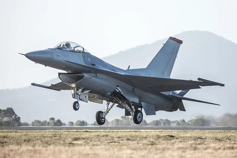
6.3 Military Aircraft
Military jets (e.g., F-16, C-130) use ruggedized DME Aircraft Systems designed for combat and harsh environments. Key adaptations include:
- Jamming Resistance: Signals are encrypted to avoid interference from enemy jamming devices.
- TACAN Integration: Paired with TACAN (Tactical Air Navigation) systems, which combine DME with azimuth data for precise positioning in combat zones.
- Survivability: Antennas and equipment are shielded to withstand gunfire, shrapnel, and extreme temperatures.
A military pilot flying an F-16 on a combat mission uses DME to:
- Navigate to a target without relying on GPS (which may be jammed).
- Coordinate with other aircraft in the formation (maintaining safe separation).
- Return to base safely after the mission.
7. Maintenance and Testing for DME Aircraft Systems
Like all avionics, DME Aircraft Systems require regular maintenance to ensure reliability. Neglecting maintenance can lead to inaccurate readings or system failure—putting flights at risk. Here’s what you need to know:
7.1 Routine Maintenance Tasks
- Visual Inspections: Technicians check the DME antenna for damage (e.g., cracks, corrosion, loose connections) and ensure wiring is intact. This is done during pre-flight checks and scheduled maintenance.
- Functional Checks: The system is tested to verify it can send/receive pulses and display accurate distances. This involves:
- Selecting a nearby DME station and comparing the displayed distance to the known distance.
- Ensuring the system switches smoothly between stations.
- Calibration: Over time, DME systems can drift out of calibration (leading to inaccurate readings). Technicians use specialized test equipment (e.g., DME simulators) to adjust the system to meet ICAO accuracy standards (±0.25 NM or 3% of distance).
- Software Updates: Digital DME systems require periodic software updates to fix bugs, improve performance, and comply with new regulations.
7.2 Performance Testing
To ensure DME Aircraft Systems work in all conditions, technicians conduct:
- Range Testing: Verifying the system can receive signals from ground stations at maximum range (e.g., 199 NM at high altitude).
- Interference Testing: Ensuring the system is not affected by other radio signals (e.g., communication radios, GPS).
- Environmental Testing: Exposing the system to extreme temperatures (-40°C to 50°C), humidity, and vibration to simulate flight conditions.
7.3 Troubleshooting Common Issues
Even with maintenance, DME systems can experience problems. Common issues and solutions include:
- Signal Loss: Check the antenna for damage, wiring for breaks, or the ground station for outages. If the station is down, switch to an alternate station.
- Inaccurate Readings: Recalibrate the system or check for interference from other avionics.
- Display Malfunctions: Replace the display unit or check the connection between the processor and display.
8. How Haisen Enhances DME Aircraft Systems
Haisen’s aviation solutions are designed to make DME Aircraft Systems more accurate, reliable, and user-friendly. Whether you’re operating a small GA plane or a large airliner, Haisen’s products complement your existing DME setup—filling gaps and boosting performance.
8.1 Key Haisen Solutions for DME
- High-Precision DME Antennas: Haisen’s antennas offer better signal reception than standard models, with:
- Enhanced gain (extending range by up to 10%).
- Improved resistance to interference (critical in busy airspace).
- Lightweight, aerodynamic design (reducing drag and fuel consumption).
- Digital DME Processors: Haisen’s processors calculate distance faster and more accurately than traditional units, with:
- Real-time error correction (reducing inaccuracies to ±0.1 NM).
- Integration with modern MFDs (displaying distance alongside GPS and VOR data).
- Built-in BIST (alerting pilots to malfunctions before they impact flight).
- Ground Station Support: Haisen provides maintenance and upgrade services for ground-based DME stations, ensuring they operate at peak performance.
8.2 Benefits of Haisen’s DME Enhancements
- Improved Safety: More accurate distance data reduces the risk of terrain collisions or mid-air incidents.
- Increased Efficiency: Better signal reception means fewer signal losses, reducing delays and fuel waste.
- Cost Savings: Haisen’s durable antennas and processors have a longer lifespan than standard components—lowering maintenance costs.
- Regulatory Compliance: All Haisen products meet ICAO, FAA, and EASA standards, ensuring your aircraft is compliant with global regulations.
9. Conclusion: DME Aircraft Systems—Non-Negotiable for Safe Flight
DME Aircraft Systems are more than just avionics—they are a lifeline for pilots. They provide precision in low visibility, reliability when GPS fails, and compliance with global regulations. From commercial airliners crossing oceans to private pilots landing in fog, DME ensures every flight is safer and more efficient.
As aviation technology evolves (with digitalization and miniaturization), DME Aircraft Systems will only become more advanced. They will integrate more closely with GPS, RNAV, and ADS-B (Automatic Dependent Surveillance-Broadcast) systems, creating a seamless navigation ecosystem. But one thing will never change: their role as a critical backup and primary distance tool for pilots.
For pilots, operators, and maintenance teams, investing in high-quality DME Aircraft Systems (and enhancements like Haisen’s) is an investment in safety. It’s not just about complying with rules—it’s about ensuring every takeoff and landing is a success.
Ready to enhance your DME Aircraft Systems? Haisen’s team of aviation experts is here to help. We offer:
- Customized DME solutions for all aircraft types.
- Maintenance and testing services.
- Training for pilots and technicians on DME operation.