Real-Time Weather for Aviation
In the dynamic landscape of global aviation, an AWOS weather system stands as an indispensable pillar for flight safety, delivering real-time meteorological data that empowers pilots and air traffic controllers to make mission-critical decisions at every stage of flight operations. Every second of accurate weather insight from an Automated Weather Observing System (AWOS) mitigates risks associated with sudden atmospheric changes, turning unpredictable weather into a manageable variable for airports of all sizes across the Americas, Middle East, and East Asia.
Aviation safety is a non-negotiable priority, where even the smallest gap in weather intelligence can lead to catastrophic outcomes. AWOS technology has redefined how the aviation industry interacts with meteorological data, moving beyond static forecasts to provide continuous, 24/7 monitoring of core atmospheric parameters that directly impact takeoff, landing, and in-flight navigation. From small regional airports lacking dedicated meteorological teams to major international hubs handling thousands of flights daily, the AWOS weather system adapts to diverse operational needs, ensuring that no pilot is left without the real-time data they need to navigate safely. This article dives into the core functionality of AWOS, its key differences from complementary systems like ASOS and AWSS, the advanced capabilities of AWOS 3, and how industry-leading solutions such as Haisen’s Aviation Automatic Weather Observation Station are setting new standards for aviation weather monitoring worldwide.
What Is an AWOS Weather System in Aviation Meteorology?
At its core, an AWOS weather system is an automated meteorological infrastructure engineered to collect, process, and disseminate real-time weather data at airport sites, with zero or minimal human intervention. Unlike manual weather observations, which are prone to delays and human error, AWOS operates autonomously, gathering data on a suite of critical atmospheric parameters and transmitting it instantly to pilots, air traffic control towers, and aviation operations centers via radio, internet feeds, and VHF frequencies. The primary purpose of an AWOS weather system is to eliminate information lag—one of the biggest threats to flight safety—by putting the most current weather conditions at the fingertips of aviation professionals, no matter the time or location.
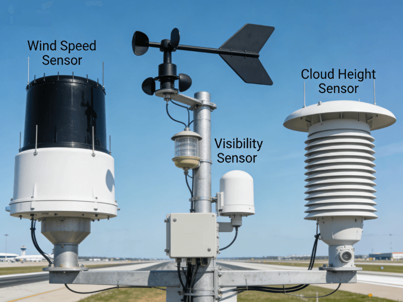
The design of an AWOS weather system is built around three core components, each working in tandem to deliver reliable, accurate data: sensors, data processing units, and communication modules. The sensor suite is the foundation, with specialized devices calibrated to measure temperature, relative humidity, wind speed and direction (including gusts), horizontal visibility, cloud height and ceiling, atmospheric pressure (altimeter setting), and in advanced models, runway surface conditions and precipitation type. These sensors are strategically placed across airport premises—typically near runways and approach zones—to capture the most relevant weather conditions for flight operations, adhering to FAA and ICAO aviation meteorology standards.
Data processing units act as the "brain" of the AWOS weather system, filtering raw sensor data, applying quality control algorithms, and converting it into standardized, easy-to-interpret aviation weather formats such as METAR (Aviation Routine Weather Report) and SPECI (Special Weather Report). This processing ensures that outliers or sensor malfunctions do not skew critical data, maintaining the integrity of the information pilots rely on. The communication module then distributes this processed data through multiple channels: a computer-generated voice broadcast on dedicated VHF frequencies (updated at least once per minute), dial-up telephone access, and digital feeds to national weather networks and airport operational systems. For pilots in the terminal area, this means accessing AWOS weather data with a simple radio tune-in, while air traffic controllers receive real-time updates directly to their workstations for seamless traffic management.
Key Meteorological Parameters Monitored by AWOS
The value of an AWOS weather system lies in its ability to track the atmospheric parameters that have the most direct impact on flight safety and aircraft performance—each measurement tailored to the unique demands of aviation operations. Every parameter monitored by AWOS is chosen for its role in decision-making, from pre-flight planning to emergency in-flight adjustments, and together they create a comprehensive picture of the local weather environment at an airport.
1. Temperature and Humidity: Air temperature directly affects aircraft engine performance and lift capacity, with hot and humid air reducing air density and increasing the runway length needed for takeoff. An AWOS weather system provides real-time dry bulb temperature and dew point readings, allowing pilots to calculate density altitude—a critical metric for adjusting takeoff and climb performance, especially at high-altitude airports in regions like the Middle East and mountainous areas of East Asia.
2. Wind Speed and Direction: Wind is the single most influential factor in takeoff and landing procedures, and an AWOS weather system captures real-time wind data, including sustained speed, direction (in magnetic degrees), and gusts. This data lets pilots determine the optimal runway for takeoff/landing (into the wind for maximum lift) and adjust approach speeds to account for crosswinds, a major hazard for low-visibility operations.
3. Visibility and Runway Visual Range (RVR): Horizontal visibility and RVR are non-negotiable for safe flight operations, with minimum visibility thresholds set for all airport categories. An AWOS weather system uses forward-scattering sensors to measure visibility up to 10 miles and RVR for runway-specific conditions, providing precise data that determines whether a flight can proceed with visual flight rules (VFR) or requires instrument flight rules (IFR) operations. Low visibility is a leading cause of flight delays and diversions, and real-time AWOS data lets airports and pilots make proactive decisions to avoid risks.
4. Cloud Height and Ceiling: Cloud height (measured in feet above ground level) and ceiling (the height of the lowest broken or overcast cloud layer) are critical for avoiding turbulence, icing, and low-level flight hazards. An AWOS weather system uses ceilometers to detect cloud layers and calculate ceiling height, alerting pilots to conditions that may require altitude adjustments or instrument approaches. This is especially vital for East Asian airports with frequent fog and low cloud cover, and Middle Eastern airports prone to sudden dust storms that reduce cloud visibility.
5. Atmospheric Pressure: Barometric pressure (altimeter setting) is essential for calibrating aircraft altimeters, ensuring that pilots have an accurate reading of their altitude above sea level and ground level. An AWOS weather system provides real-time sea-level pressure and altimeter setting data, with pressure trend indicators that signal approaching weather systems—such as low-pressure fronts bringing storms or high-pressure systems causing clear air turbulence. This early warning lets pilots adjust flight paths to avoid oncoming hazardous weather.
In addition to these core parameters, advanced AWOS weather system models (such as AWOS 3) can monitor additional metrics like precipitation accumulation, thunderstorm activity, and runway surface temperature—all of which add layers of safety for operations in adverse weather conditions. The continuous monitoring of these parameters means that the AWOS weather system never misses a change in the weather, providing a constant stream of data that keeps aviation professionals one step ahead of atmospheric shifts.
AWOS vs. ASOS vs. AWSS: Understanding Critical Differences
For aviation professionals, understanding the distinctions between AWOS weather system, ASOS (Automated Surface Observing System), and AWSS (Automated Weather Sensor System) is essential for selecting the right meteorological tool for their airport’s operational needs. While all three systems deliver real-time weather data for aviation, they differ in their design focus, functionality, and use cases—with the AWOS weather system standing out for its aviation-specific customization and flexibility, especially for smaller to mid-sized airports.
First, the similarities: all three systems measure the core meteorological parameters (temperature, wind, visibility, pressure) and adhere to global aviation weather standards, providing data that supports VFR and IFR operations. They all operate autonomously, reducing the need for manual weather observations, and disseminate data through standardized aviation formats. For airports across the Americas, Middle East, and East Asia, this shared foundation ensures consistency in weather data, no matter which system is deployed.
The key differences emerge in their design intent and advanced capabilities, starting with the AWOS weather system and ASOS. ASOS is a federal government-managed system (a joint effort of the FAA, NWS, and DoD in the US) designed as a universal surface observing system for both aviation and general meteorological use. It is primarily deployed at large commercial airports and focuses on broad surface weather observations, with limited customization for aviation-specific needs. In contrast, the AWOS weather system is a privately or locally managed system engineered exclusively for aviation, with features tailored to the unique demands of flight operations. What sets the AWOS weather system apart is its ability to include aviation-specific sensors—such as runway condition monitors and cloud type detectors—and its flexibility to scale based on an airport’s size. For small regional airports in the Middle East or East Asia that lack federal meteorological support, the AWOS weather system is the ideal solution, as it provides the critical aviation data they need without the overhead of a full ASOS installation. Additionally, the AWOS weather system transmits data directly to pilots via on-site VHF radio, a feature that is often a secondary function for ASOS.
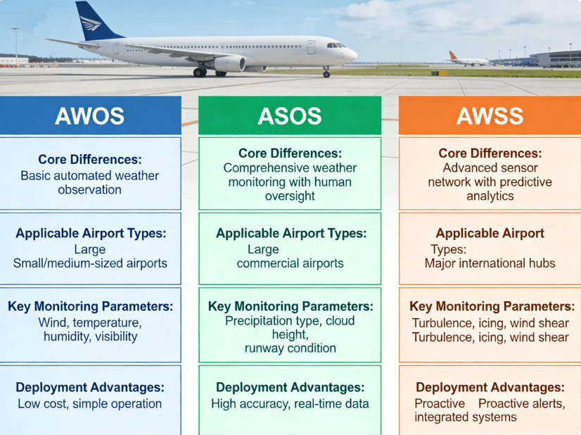
The distinction between the AWOS weather system and AWSS is equally important, as AWSS represents a more advanced, integrated iteration of automated weather sensing. AWSS builds on the core functionality of the AWOS weather system by incorporating more sophisticated sensors, advanced data processing algorithms, and seamless integration with other aviation technologies—such as air traffic control systems, flight management software, and airport operation platforms. While the AWOS weather system delivers reliable real-time data for standalone use, AWSS provides enhanced, detailed data and system interoperability, making it ideal for large international airports with high flight volumes and complex operational needs. For example, AWSS can integrate weather data with runway usage data to alert air traffic controllers to potential hazards (e.g., a wet runway combined with crosswinds), while a standard AWOS weather system focuses on delivering the raw weather data itself. Another key difference is data granularity: AWSS provides more frequent data updates (sometimes in real time, as opposed to the 1-minute updates of a standard AWOS weather system) and more detailed measurements (e.g., wind gusts in 5-second intervals vs. 10-second intervals for AWOS).
Despite these differences, the AWOS weather system remains the most versatile and cost-effective solution for the majority of airports worldwide. It strikes the perfect balance between functionality and practicality, delivering all the aviation-specific weather data needed for safe operations without the complexity and cost of AWSS or the one-size-fits-all design of ASOS. For airports in the Americas, Middle East, and East Asia—where operational needs range from small rural airfields to busy regional hubs—the AWOS weather system is the backbone of aviation weather monitoring, with the flexibility to upgrade to advanced models like AWOS 3 as operations grow.
AWOS 3: The Advanced Evolution of the AWOS Weather System
For airports seeking the next level of aviation weather monitoring, AWOS 3 represents the gold standard in AWOS technology—an advanced iteration of the AWOS weather system that combines enhanced sensing capabilities, automated reporting, and seamless integration to deliver unrivaled safety and operational efficiency for aviation operations. AWOS 3 is not just an upgrade to the standard AWOS weather system; it is a fully optimized meteorological solution designed for the most demanding aviation environments, from busy regional airports to international hubs with high flight volumes and complex weather conditions.
The core features of AWOS 3 build on the foundational AWOS weather system design, with key enhancements that address the evolving needs of the aviation industry. First and foremost, AWOS 3 maintains the 24/7 autonomous operation of the standard AWOS weather system, with even more robust sensor technology that delivers higher precision and reliability. It monitors all the core meteorological parameters (temperature, wind, visibility, cloud height, pressure) with enhanced accuracy—for example, wind direction measured to the nearest 5 degrees vs. 10 degrees for standard AWOS, and visibility measurements with a margin of error of less than 50 feet. This level of precision is critical for operations in adverse weather conditions, such as the heavy fog common in East Asian coastal airports or the sudden sandstorms in the Middle East, where small variations in weather data can have a big impact on flight safety.
Another defining feature of AWOS 3 is its automated, scheduled reporting capability, a step beyond the on-demand data transmission of the standard AWOS weather system. AWOS 3 generates and disseminates standardized METAR and SPECI reports at pre-set intervals (e.g., every 30 minutes for METAR, instantly for SPECI when weather conditions change significantly), eliminating the need for manual report generation and ensuring that aviation professionals have access to consistent, up-to-date weather data. This automated reporting is fully compliant with FAA and ICAO standards, making AWOS 3 a reliable solution for airports that need to submit official weather data to national and international aviation authorities. Additionally, AWOS 3 can generate custom reports for airport operations teams, such as runway weather condition summaries or hourly weather trend analyses, providing tailored insights that drive better operational decisions.
AWOS 3 also enhances the communication capabilities of the standard AWOS weather system, with multiple redundant data transmission channels to ensure that weather data is always available, even in the event of a technical failure. It supports VHF radio broadcast, internet feeds, cellular data, and satellite communication—critical for airports in remote regions of the Americas, Middle East, and East Asia with limited terrestrial communication infrastructure. For pilots, this means that AWOS 3 data is accessible whether they are on the ground, in the terminal area, or en route to the airport, while air traffic controllers receive real-time updates to their workstations with zero lag. This seamless communication reduces pilot workload and improves coordination between pilots and ground control, a key factor in enhancing flight safety during critical phases of flight (takeoff and landing).
The benefits of AWOS 3 extend far beyond enhanced data precision—they translate directly to improved operational efficiency for airports and airlines. By providing real-time, accurate weather data, AWOS 3 lets airlines optimize flight schedules and routes, minimizing delays and diversions caused by unexpected weather changes. For example, if an AWOS 3 system detects a sudden increase in crosswinds on a runway, air traffic controllers can quickly reassign flights to a more suitable runway, avoiding costly delays and keeping operations on track. For airports, AWOS 3 reduces the need for manual weather observations, cutting labor costs and freeing up staff to focus on other critical operational tasks. It also ensures compliance with global aviation safety standards, a must for airports seeking to attract international flights and expand their operations.
For pilots, the benefits of AWOS 3 are even more direct: enhanced situational awareness that lets them make informed decisions at every stage of flight. Unlike static forecasts, which can quickly become outdated, AWOS 3 provides real-time weather data that reflects the current conditions at the airport, allowing pilots to adjust their approach speeds, landing gear settings, and flight paths to match the actual weather—rather than relying on predictions. This is especially valuable in adverse weather conditions, where AWOS 3 data can mean the difference between a safe landing and a diversion to another airport. In the words of many pilots, AWOS 3 turns "weather uncertainty" into "weather certainty," a critical advantage in an industry where safety is always the top priority.
Haisen’s Aviation Automatic Weather Observation Station: Redefining the AWOS Weather System
While the AWOS weather system is already a powerful tool for aviation safety, industry-leading solutions like Haisen’s Aviation Automatic Weather Observation Station are raising the bar, combining the core functionality of AWOS (and AWOS 3) with cutting-edge technology, customized design, and global adaptability to deliver a weather monitoring solution that meets the unique needs of airports across the Americas, Middle East, and East Asia. Haisen’s AWOS weather system is not just a standard automated observing station—it is a fully optimized, end-to-end meteorological solution engineered for maximum reliability, accuracy, and ease of use, making it the preferred choice for airports of all sizes seeking to enhance their flight safety and operational efficiency.
At the heart of Haisen’s AWOS weather system is its commitment to continuous real-time data delivery—a feature that sets it apart from generic AWOS solutions. Haisen’s system uses a next-generation sensor suite, calibrated to perform in the most extreme weather conditions: from the high temperatures and sandstorms of the Middle East (up to 55°C) to the heavy rain and fog of East Asia, and the extreme cold and wind of the northern Americas. Each sensor is built with rugged, weather-resistant housing and advanced anti-interference technology, ensuring that it delivers accurate data even in harsh environmental conditions— a critical advantage for airports in regions with extreme or variable weather. The sensor suite includes all core AWOS parameters, plus optional advanced sensors for runway surface conditions, precipitation type, and thunderstorm detection, letting airports customize the system to their specific operational needs.
Another key strength of Haisen’s AWOS weather system is its data processing and integration capability, which builds on the advanced features of AWOS 3 to deliver even more value for aviation operations. Haisen’s system uses AI-powered quality control algorithms to filter raw sensor data, eliminating noise and ensuring that only accurate, reliable data is transmitted to pilots and air traffic control. It also integrates seamlessly with other airport technologies—including air traffic control systems, flight management software, and airport operation platforms—allowing weather data to be combined with other operational data to drive better decision-making. For example, Haisen’s AWOS weather system can share real-time runway weather data with airport maintenance teams, alerting them to wet or icy runways that need treatment, and with air traffic controllers, who can use the data to optimize runway usage and reduce delays. This level of integration turns the AWOS weather system from a standalone tool into a core component of the airport’s overall operational ecosystem.
Haisen’s AWOS weather system also prioritizes ease of deployment and maintenance, a critical factor for airports in remote regions with limited technical staff. The system is pre-assembled and pre-calibrated at the factory, meaning it can be installed at an airport in a matter of days—no extensive on-site setup required. It also features remote monitoring and maintenance capabilities, allowing Haisen’s technical team to diagnose and resolve issues from a central location, reducing downtime and ensuring that the AWOS weather system is always operational. For airports in the Middle East, East Asia, and the Americas that lack dedicated meteorological or technical staff, this remote support is a game-changer, ensuring that their AWOS weather system remains reliable and accurate with minimal on-site effort.
The impact of Haisen’s AWOS weather system on flight safety and operational efficiency is measurable and far-reaching. For pilots, the system’s continuous real-time data means that they always have the most current weather conditions at their fingertips, allowing them to make informed decisions that reduce the risk of weather-related incidents. For air traffic controllers, the system’s accurate, timely data lets them manage air traffic more effectively, anticipating potential hazards and adjusting operations to avoid delays and diversions. For airports, the system’s cost-effectiveness and low maintenance requirements mean that they can enhance their weather monitoring capabilities without breaking the bank, while complying with global aviation safety standards. For airlines, the system’s data reduces flight delays and diversions, cutting costs and improving customer satisfaction. In short, Haisen’s AWOS weather system delivers value for every stakeholder in the aviation ecosystem, making it a smart investment for any airport looking to enhance its flight safety and operational efficiency.
The Future of AWOS Weather Systems in Global Aviation
The AWOS weather system has already transformed aviation weather monitoring, but the future holds even more exciting developments that will further enhance flight safety and operational efficiency for airports across the Americas, Middle East, and East Asia. As technology continues to evolve—with advancements in AI, sensor technology, and data analytics—the AWOS weather system is set to become even more intelligent, adaptive, and integrated, turning real-time weather data into predictive insights that let aviation professionals anticipate weather changes before they happen.
One of the biggest trends in the future of the AWOS weather system is the integration of artificial intelligence (AI) and machine learning (ML) into data processing and analysis. Current AWOS systems deliver real-time data on current weather conditions, but AI-powered AWOS systems will go a step further, using historical weather data and real-time sensor inputs to predict short-term weather changes (e.g., a sudden drop in visibility, an increase in crosswinds, or the approach of a thunderstorm) with high accuracy. This predictive capability will let pilots and air traffic controllers make proactive decisions—such as adjusting flight paths or reassigning runways—before the weather changes, eliminating the risk of last-minute surprises and further enhancing flight safety. For example, an AI-powered AWOS weather system in an East Asian airport could predict fog formation 30 minutes before it occurs, letting air traffic controllers alert incoming flights and adjust operations to avoid delays.
Another key development is the miniaturization and enhancement of sensor technology, which will make the AWOS weather system even more flexible and accurate. Future AWOS sensors will be smaller, lighter, and more powerful, with the ability to measure an even wider range of meteorological parameters—such as air turbulence, icing conditions, and air quality (for airports in urban areas). These advanced sensors will also be more energy-efficient, making the AWOS weather system suitable for remote airports with limited power infrastructure, such as rural airfields in the Americas or Middle East. Additionally, sensor technology will become more affordable, letting even the smallest airports deploy advanced AWOS weather systems and access the same real-time weather data as major international hubs.
Interoperability and global data sharing will also be a major focus for the future of the AWOS weather system. As aviation becomes increasingly global, there is a growing need for consistent, standardized weather data across all airports worldwide. Future AWOS weather systems will be designed to integrate seamlessly with global aviation weather networks, such as the FAA’s Aviation Surface Weather Observation Network (ASWON) and the ICAO’s Global Meteorological Watch Programme, allowing weather data to be shared in real time between airports, airlines, and meteorological authorities across the globe. This global data sharing will enhance flight safety for international flights, as pilots will have access to consistent weather data from departure, en route, and arrival airports—no matter where they are in the world. For example, a flight from the US to the Middle East will have real-time access to AWOS weather data from both the departure airport in the Americas and the arrival airport in the Middle East, ensuring a seamless and safe journey.
Finally, the future of the AWOS weather system will focus on user-centric design, making the system even easier to use for pilots, air traffic controllers, and airport operations teams. Future AWOS systems will feature intuitive user interfaces, mobile access, and customizable data displays, letting users access the exact weather data they need in the format they prefer—whether it’s a pilot checking wind data on their tablet or an air traffic controller viewing a real-time weather map on their workstation. This user-centric design will reduce pilot and controller workload, making it even easier to access and interpret critical weather data, and further enhancing flight safety.
Why Every Airport Needs a Reliable AWOS Weather System
In the global aviation industry, where safety and efficiency are the cornerstones of success, a reliable AWOS weather system is not just a nice-to-have—it is a necessity. For airports of all sizes, from small regional airfields to major international hubs, the AWOS weather system delivers the real-time meteorological data needed to make informed decisions, mitigate weather-related risks, and keep operations running smoothly. In the Americas, Middle East, and East Asia—where weather conditions range from extreme heat and sandstorms to heavy fog and rain—the AWOS weather system is an indispensable tool for adapting to diverse and variable atmospheric conditions, ensuring that flight safety is never compromised by weather uncertainty.
The value of an AWOS weather system extends far beyond flight safety; it also drives operational efficiency and cost savings for airports and airlines. By providing real-time weather data, the AWOS weather system reduces flight delays and diversions, cutting costs for airlines and improving customer satisfaction. It also reduces the need for manual weather observations, cutting labor costs for airports and freeing up staff to focus on other critical operational tasks. For small airports, the AWOS weather system is a cost-effective way to comply with global aviation safety standards and attract more flights, while for large airports, it is a core component of a comprehensive weather monitoring strategy that supports thousands of flights daily.
Industry-leading solutions like Haisen’s Aviation Automatic Weather Observation Station take the AWOS weather system to the next level, combining advanced technology, global adaptability, and user-centric design to deliver a solution that meets the unique needs of airports across the world. Haisen’s AWOS weather system is engineered for maximum reliability and accuracy in the most extreme weather conditions, with seamless integration and remote maintenance capabilities that make it easy to deploy and manage—even for airports with limited technical staff. For airports looking to enhance their flight safety and operational efficiency, Haisen’s AWOS weather system is the smart choice, delivering unrivaled value and performance for every stakeholder in the aviation ecosystem.
As the aviation industry continues to grow and evolve, the AWOS weather system will remain a pillar of flight safety, adapting to new technologies and global operational needs to deliver the real-time weather data that aviation professionals need to navigate safely. From the advanced capabilities of AWOS 3 to the AI-powered predictive insights of the future, the AWOS weather system is set to redefine how the aviation industry interacts with meteorological data, turning weather uncertainty into weather certainty and ensuring that the skies remain safe for every flight, every day.
If you’re an airport operator, aviation manager, or pilot looking to enhance your flight safety and operational efficiency with a reliable, advanced AWOS weather system, Haisen’s Aviation Automatic Weather Observation Station is the solution you’ve been looking for. With customized design, global adaptability, and industry-leading technology, Haisen’s AWOS weather system is engineered to meet the unique needs of airports across the Americas, Middle East, and East Asia—delivering the real-time weather data you need to keep your operations safe, efficient, and compliant with global aviation standards. Contact Haisen today to learn more about how our AWOS weather system can transform your airport’s weather monitoring capabilities and elevate your flight safety to new heights.