Essential Insights for Pilots & Operators
Aviation Distance Measuring Equipment (DME) is the backbone of precise, real-time navigation for aircraft worldwide, delivering critical slant-range data that underpins safe en-route flight, low-visibility approaches, and efficient air traffic management. Every modern aviation operation relies on DME aviation technology to bridge the gap between positional awareness and operational safety, making it an indispensable tool for pilots, air traffic controllers, and aviation infrastructure planners across the Americas, Middle East, and East Asia.
In the dynamic landscape of global aviation, where weather challenges, busy airways, and strict safety regulations define daily operations, DME stands as a non-negotiable navigational aid. Unlike satellite-based systems that can face interference or outages, ground-based DME aviation systems provide consistent, reliable distance measurement between an aircraft and fixed ground stations, operating in the 960–1215 MHz UHF band to ensure line-of-sight signal integrity. For commercial airlines, general aviation pilots, and aviation technology providers, understanding how DME works, its key applications, and its integration with other navigational tools like VOR (VHF Omnidirectional Range) and ILS (Instrument Landing System) is critical to optimizing flight efficiency and mitigating operational risks. This comprehensive guide breaks down the core functionality, types, key benefits, and real-world applications of DME in aviation, equipping aviation professionals with the knowledge to leverage this technology for safer, more efficient flight operations—whether navigating mountainous terrain in the Middle East, busy air corridors in East Asia, or transcontinental routes across the Americas.
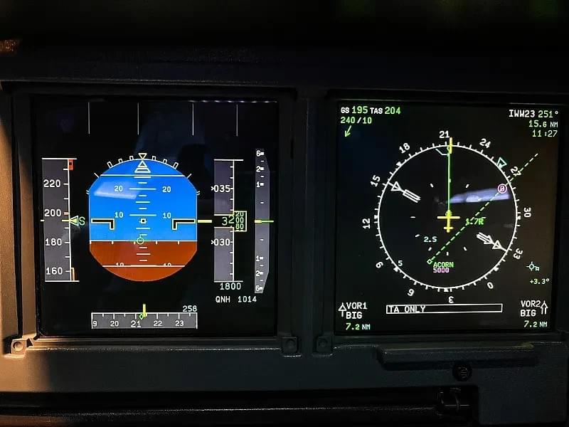
At its most fundamental level, DME (Distance Measuring Equipment) is a radio navigation technology designed to calculate the slant range—the straight-line distance—between an airborne aircraft and a ground-based DME transponder station. This measurement, displayed in nautical miles (nm) on the aircraft’s cockpit instruments (e.g., HSI, PFD), is updated continuously (every 0.5–2 seconds) to provide pilots with real-time positional data relative to key navigational points, such as airports, waypoints, and airway intersections. The precision of DME aviation systems is unrivaled for critical operations: the total system error is limited to ±370 meters (0.2 nm) at a 95% probability rate, meeting the strict technical standards set by the International Civil Aviation Organization (ICAO), FAA, and CAAC.
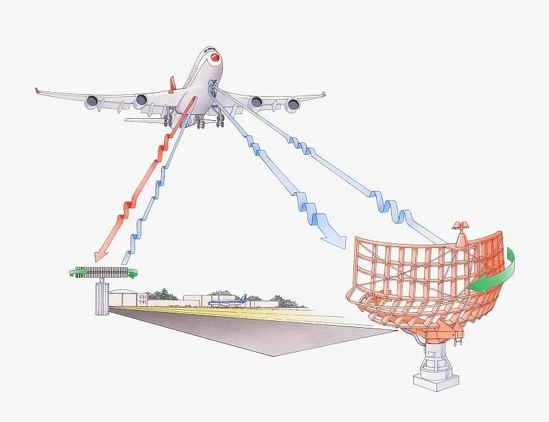
The functionality of DME is rooted in a simple yet highly precise time-of-flight signal exchange process, a cornerstone of DME aviation technology that has remained consistent since its invention in Australia in the post-WWII era. Here’s a step-by-step breakdown of how every DME system operates:
- Signal Interrogation: The aircraft’s onboard DME interrogator transmits a coded pair of radio pulses at an assigned frequency in the 960–1215 MHz band. These pulse pairs have unique spacing (X or Y mode) to ensure no signal interference between multiple aircraft querying the same ground station.
- Ground Station Response: The ground-based DME transponder receives the interrogation pulses, verifies their validity, and immediately transmits a reply pulse pair on a frequency offset by 63 MHz from the original signal—this offset eliminates cross-talk between incoming and outgoing signals.
- Time Delay Calculation: The airborne DME equipment measures the time elapsed between sending the interrogation pulse and receiving the reply. Since radio waves travel at the speed of light (186,000 miles/second or 300,000 km/second), the system calculates the slant range by multiplying the time delay by the speed of light and dividing by two—this division accounts for the signal traveling to the ground station and back to the aircraft.
- Real-Time Display: The calculated slant range is instantly displayed on the pilot’s navigation instruments, integrated with other critical flight data to provide a complete positional picture. This seamless data flow is why DME is the go-to navigational aid for low-visibility operations, where visual references are unavailable.
A key characteristic of DME aviation systems is their ability to handle high traffic volume: a single ground DME transponder can process up to 100 aircraft interrogations simultaneously, making it ideal for busy airspaces in major aviation hubs like Dubai, Tokyo, and New York. Unlike GPS, which provides horizontal distance to a waypoint, DME measures slant range— the direct line between the aircraft (at altitude) and the ground station—making it critical for approach and landing procedures where altitude and distance alignment are non-negotiable. This unique capability is why DME remains irreplaceable in modern aviation, even with the rise of satellite-based navigation.
Two Primary Types of DME in Aviation: Low-Power & High-Power
DME aviation systems are classified into two main types based on transmission power, each designed for specific aviation operations and integrated with complementary navigational aids to maximize functionality. The classification—low-power DME (LPDME) and high-power DME (HPDME)—follows global technical standards (FAA, CAAC, ICAO) and is tailored to the needs of terminal navigation (airport approaches/landings) and en-route navigation (long-distance airway flight), respectively. Understanding the differences between these two DME types is essential for aviation operators, infrastructure planners, and pilots working across diverse regions, from the dense airport networks of East Asia to the long-haul routes of the Americas and the remote terrain of the Middle East.
Low-Power DME (LPDME): Terminal Navigation for Approaches & Landings
Low-power DME systems transmit at 100 watts of power and are exclusively used for terminal navigation—the critical phase of flight involving airport approaches, landings, and departures. LPDME is almost always collocated with the Instrument Landing System (ILS) or ILS localizer, serving as a direct replacement for outer marker beacons in situations where marker beacon siting is not feasible. This integration is a game-changer for low-visibility operations (e.g., fog, rain, low cloud cover) in regions like Northern East Asia and the Pacific Northwest of the Americas, where poor weather is a frequent operational challenge.
LPDME provides pilots with precise distance data to key landing waypoints, such as the final approach fix (FAF) and touchdown zone, reducing the probability of missed approaches and approach-related accidents. For aviation infrastructure, LPDME offers a cost-effective alternative to traditional marker beacons, with lower maintenance requirements and greater signal reliability. According to FAA criteria, LPDME installation at ILS-equipped runways reduces localizer minima, averting flight disruptions and minimizing delays— a critical benefit for busy airports in Dubai, Hong Kong, and Los Angeles, where on-time performance is a top operational priority. Technically, LPDME adheres to CAAC’s MH/T 4006.3-1998 standard, which mandates that terminal DME systems have a coverage area matching the ILS azimuth guidance sector, ensuring consistent signal strength throughout the approach phase.
High-Power DME (HPDME): En-Route Navigation for Global Airways
High-power DME systems transmit at 1,000 watts of power and are the workhorses of en-route navigation, supporting long-distance flight across international airways. HPDME is almost always collocated with VOR (VHF Omnidirectional Range) stations, forming a VOR-DME navigation system that provides pilots with both azimuth (direction) and slant range (distance) data— a two-dimensional positional solution that is the foundation of global airway navigation. This collocation is standard across the Americas, Middle East, and East Asia, with VOR-DME stations placed every 150 km on average along major air routes to ensure continuous coverage.
HPDME is a critical component of RNAV (Area Navigation) en-route instrument flight procedures (IFP), enabling aircraft to navigate beyond fixed airways by using multiple HPDME stations for position triangulation. For transcontinental flights across the Americas, long-haul routes from the Middle East to East Asia, and flights over remote terrain (e.g., the Arabian Desert, the Himalayas), HPDME provides a resilient backup to GPS navigation— a vital feature in GPS-denied environments caused by jamming, satellite outages, or terrain blockage. The FAA’s NextGen DME Program specifically sustains HPDME infrastructure to ensure RNAV capability and navigational redundancy, a priority for global aviation safety regulators. Technically, HPDME systems meet ICAO and CAAC standards for coverage, with a service volume matching the associated VOR station— typically up to 200 km in range— and the ability to operate in X/Y pulse modes to avoid frequency interference.
Both LPDME and HPDME share core technical specifications that define DME aviation technology globally: all systems use vertical polarization waves, operate in the 960–1215 MHz band, and feature solid-state components with dual-machine configuration (excluding antennas) for uninterrupted operation. Ground DME stations also include a full suite of supporting systems— transponder, monitoring, control, antenna, and power— to ensure 24/7 reliability, a requirement for aviation operations that never stop, regardless of region or time zone.
The adoption of DME aviation technology across the globe is driven by its unmatched ability to enhance flight safety, optimize operational efficiency, and provide navigational resilience— benefits that resonate with aviation stakeholders in every region, from commercial airlines in East Asia to general aviation operators in the Americas and military aviation in the Middle East. Based on FAA benefit-cost analysis and real-world operational data, DME delivers five transformative advantages that make it a cornerstone of modern air navigation, addressing critical pain points like missed approaches, flight disruptions, and navigational uncertainty. These benefits are not just technical— they translate to tangible operational value, including reduced costs, improved on-time performance, and enhanced passenger safety.
1. Eliminates the Need for Outer Marker Beacons (ILS Compatibility)
DME serves as a reliable replacement for ILS outer marker beacons, a critical benefit for airports where marker beacon siting is geographically or logistically unfeasible. Outer marker beacons are limited by their fixed location and signal range, while DME provides flexible, precise distance data to any waypoint in the approach phase. This replacement reduces infrastructure costs for airports and eliminates the operational limitations of marker beacons, making DME the preferred choice for ILS-equipped runways in the Middle East (e.g., Dubai International Airport), East Asia (e.g., Tokyo Haneda), and the Americas (e.g., Atlanta Hartsfield-Jackson). For pilots, this means clearer, more accurate approach guidance— a key factor in reducing low-visibility landing errors.
2. Reduces Approach Accidents & Missed Approaches
The real-time, high-precision slant range data provided by DME directly reduces the probability of approach-related accidents and missed approaches. In low-visibility conditions, where pilots rely solely on navigational aids, DME ensures accurate positioning relative to the runway, eliminating the guesswork associated with less precise navigation tools. FAA data shows that DME installation at ILS and localizer-equipped runways averted hundreds of missed approaches annually, with a corresponding reduction in approach accident risk. For airlines operating in regions with frequent low-visibility conditions (e.g., Northern China, Western Europe, the Northeastern US), this safety benefit is invaluable, reducing operational disruptions and improving passenger confidence.
3. Averts Flight Disruptions with Reduced Localizer Minima
DME integration with ILS and localizer systems allows aviation regulators to reduce localizer minima— the minimum visibility and descent altitude required for a localizer approach. Lower minima mean more flights can complete approaches in poor weather, avoiding costly diversions and delays. This benefit is particularly impactful for busy hub airports in East Asia (e.g., Seoul Incheon, Shanghai Pudong) and the Americas (e.g., Chicago O’Hare, Miami International), where even minor weather disruptions can cause cascading flight delays across global networks. For the Middle East, where sandstorms often reduce visibility, DME-enabled lower localizer minima ensure continuous airport operations, a key competitive advantage for regional aviation hubs like Doha and Abu Dhabi.
4. Expedites Departures with Shorter Flight Paths
DME provides precise distance data for departure procedures, allowing air traffic controllers to assign shorter departure flight paths without compromising safety. By knowing the exact position of an aircraft relative to the airport and surrounding airspace, controllers can clear flights for more direct departures, reducing runway congestion and increasing air traffic capacity. This benefit is critical for airports with high departure volumes, such as Dubai International (a major Middle East hub) and Los Angeles International (a key Americas gateway), where every second of runway efficiency translates to more flights and higher operational revenue. For airlines, shorter departure paths also reduce fuel consumption and emissions— a win for both operational costs and sustainability goals.
5. Resilient Backup for GPS in GPS-Denied Environments
Perhaps the most important benefit of DME aviation systems in the modern era is their role as a resilient backup for GPS navigation. While GPS is the primary navigational aid for most modern aircraft, it is vulnerable to jamming, satellite outages, and terrain blockage— issues that are increasingly common in certain regions of the world. DME, as a ground-based system, is immune to these disruptions, providing continuous navigational data in GPS-denied environments. This resilience is a top priority for military and commercial aviation in the Middle East, where jamming risks are high, and for flights over remote terrain in East Asia (e.g., the Tibetan Plateau) and the Americas (e.g., the Amazon Rainforest), where satellite coverage can be spotty. The FAA’s NextGen program and ICAO’s global navigation standards both mandate DME as a backup to GPS, ensuring that air navigation remains reliable even when satellite systems fail.
Each of these benefits reinforces why DME is not just a navigational aid— it is a strategic investment in aviation safety and efficiency. For aviation technology providers, understanding these benefits is key to designing and deploying DME systems that meet the unique needs of regional markets; for pilots and operators, it is the foundation of confident, informed decision-making in every phase of flight.
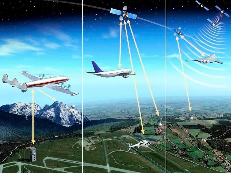
DME Integration with VOR, ILS & Other Aviation Navigational Aids
DME in aviation is never used in isolation— it is a complementary technology that integrates seamlessly with other core navigational aids to create a complete, multi-dimensional positional solution for pilots. The most common integrations— DME-VOR and DME-ILS— are global standards, adopted by the FAA, CAAC, EASA, and ICAO, and are the backbone of air navigation in the Americas, Middle East, and East Asia. These integrations leverage the strengths of each technology: VOR provides azimuth (direction), ILS provides precision approach guidance, and DME provides slant range (distance)— together, they create a navigational ecosystem that is greater than the sum of its parts. For aviation professionals, understanding how DME integrates with other systems is essential to optimizing flight operations and leveraging the full potential of modern navigation technology.
DME-VOR: The Gold Standard for En-Route Navigation
The DME-VOR integration is the most widely used navigational combination in global aviation, forming a two-dimensional (azimuth + distance) navigation system for en-route flight. VOR stations operate in the 108.0–117.95 MHz band, providing pilots with a precise direction to the ground station, while collocated HPDME stations provide slant range data— together, they allow pilots to determine their exact position on a airway with unmatched accuracy. This combination is the foundation of airway navigation across the Americas, where VOR-DME stations line transcontinental routes, and in the Middle East and East Asia, where they support both regional and long-haul flights.
Technically, DME-VOR systems use paired frequencies: the DME frequency is offset from the VOR frequency to ensure no signal interference, and both systems share a common identification signal (Morse code or voice) for easy pilot verification. For example, a VOR station operating at 112.3 MHz will have a collocated DME station operating at a paired frequency in the 960–1215 MHz band, with both systems transmitting the same 3–4 letter Morse code identifier. This standardization ensures that pilots can easily cross-verify navigational data, a key safety feature. The DME-VOR system also supports DME/DME navigation, a technique where pilots use data from two or more HPDME stations to triangulate their position— this is the core of RNAV en-route procedures, allowing aircraft to navigate beyond fixed airways and optimize flight paths for fuel efficiency.
DME-ILS: Precision Guidance for Approach & Landing
The DME-ILS integration is the critical navigational combination for terminal operations, providing pilots with precision approach and landing guidance in all weather conditions. ILS systems provide vertical (glideslope) and horizontal (localizer) guidance to the runway, while collocated LPDME systems provide slant range data to key approach waypoints— such as the FAF (Final Approach Fix) and MAP (Missed Approach Point). This integration replaces traditional outer marker beacons, providing more flexible and precise distance data that adapts to different approach procedures and airport layouts.
For low-visibility operations (Category I/II/III ILS approaches), DME-ILS is indispensable: the slant range data from DME ensures that pilots initiate descent and configure the aircraft at the correct distance from the runway, while the ILS provides the necessary vertical and horizontal guidance. CAAC and FAA standards mandate that LPDME systems collocated with ILS have a coverage area matching the ILS azimuth guidance sector, ensuring consistent signal strength throughout the approach phase. This integration is widely used at major airports in East Asia (e.g., Beijing Capital, Tokyo Narita), the Americas (e.g., New York JFK, Toronto Pearson), and the Middle East (e.g., Abu Dhabi International, Riyadh King Khalid), where low-visibility operations are a regular part of daily aviation.
DME and Other Navigational Aids: TACAN, MLS & GPS
DME also integrates with other specialized navigational aids to meet the needs of military and commercial aviation. TACAN (Tactical Air Navigation) systems, used by military aircraft, are fully compatible with civilian DME systems— a TACAN station provides the same slant range data as a DME station, allowing civilian aircraft to use military TACAN infrastructure for navigation. This compatibility is a key benefit for flights over remote regions (e.g., the Sahara Desert, the Alaskan Wilderness) where civilian DME coverage is limited. MLS (Microwave Landing System), a modern alternative to ILS, also integrates with DME for distance measurement, providing even more precise approach guidance for modern aircraft.
While GPS is the primary navigational aid for most modern flights, DME serves as a critical backup, as mandated by global aviation regulators. DME and GPS are complementary: GPS provides global horizontal positioning, while DME provides precise slant range and ground-based resilience. For aviation operators, this means a layered navigational system— if one system fails, the other takes over, ensuring that flight safety is never compromised. This redundancy is a core principle of modern aviation design, and DME is the cornerstone of this resilience.
DME aviation technology is governed by a set of strict global standards set by the International Civil Aviation Organization (ICAO), with regional regulators— including the FAA (Americas), CAAC (East Asia), and GCAA (General Civil Aviation Authority, Middle East)— adopting and adapting these standards to meet local operational needs. These standards cover every aspect of DME design, installation, operation, and maintenance, ensuring that DME systems are interoperable across borders— a critical requirement for global aviation, where aircraft fly from one region to another seamlessly. For aviation technology providers, pilots, and infrastructure planners, understanding both global DME standards and regional operational considerations is essential to deploying and using DME effectively across the Americas, Middle East, and East Asia.
Global DME Standards: ICAO, FAA & CAAC
The ICAO sets the foundational standards for DME in aviation, outlined in Annex 10 (Aeronautical Telecommunications) of the Chicago Convention— these standards define the technical specifications for DME systems, including frequency band (960–1215 MHz), power output, signal format (X/Y pulse modes), and accuracy requirements (±0.2 nm error). All global DME systems must comply with these standards to ensure interoperability, a key requirement for international flights.
In the Americas, the FAA is the primary regional regulator for DME aviation systems, with standards outlined in FAA Order 8200.1 and the AIM (Aeronautical Information Manual). The FAA’s standards build on ICAO’s foundation, with additional requirements for DME installation at ILS/VOR-equipped runways, benefit-cost analysis for new DME deployments, and the integration of DME into the NextGen air transportation system. The FAA also mandates DME as a backup for GPS navigation, a key requirement for all aircraft operating under Instrument Flight Rules (IFR) in US airspace.
In East Asia, the Civil Aviation Administration of China (CAAC) sets regional DME standards with the MH/T 4006.3-1998 technical specification, which aligns with ICAO Annex 10 and adds specific requirements for DME installation in Chinese airspace. The CAAC standard mandates dual-machine configuration for all ground DME systems (excluding antennas), solid-state components for uninterrupted operation, and strict electromagnetic environment requirements for ground station siting. These standards ensure that DME systems in China are reliable and compatible with international aircraft, supporting the country’s role as a major aviation hub in East Asia.
In the Middle East, regional regulators like the GCAA (UAE) and GACA (Saudi Arabia) adopt ICAO and FAA standards for DME aviation systems, with additional considerations for operating in extreme desert conditions (e.g., high temperatures, sandstorms). Middle Eastern regulators mandate enhanced dust and temperature protection for ground DME equipment, ensuring reliable operation in the harsh desert environment— a critical requirement for aviation hubs like Dubai and Doha, which serve as key gateways between the East and West.
Regional Operational Considerations for DME
While DME standards are global, operational considerations vary by region, driven by geography, weather, air traffic volume, and infrastructure density. For DME users and providers, adapting to these regional differences is essential to maximizing the value of DME aviation technology.
Americas: Long-Haul En-Route Navigation & Busy Hubs
The Americas are characterized by long-haul transcontinental flights, vast remote regions (e.g., the Amazon, the Canadian North), and extremely busy aviation hubs (e.g., Atlanta, Los Angeles, Mexico City). DME operations in the Americas focus on HPDME-VOR integration for en-route navigation across remote regions, where GPS coverage can be spotty, and LPDME-ILS integration for busy hub airports, where low-visibility operations and high air traffic volume demand precise, reliable approach guidance. The FAA’s NextGen program also prioritizes DME/DME navigation for RNAV procedures, allowing airlines to optimize flight paths for fuel efficiency and reduce emissions— a key goal for North American aviation operators.
Middle East: Desert Operations & Global Hub Connectivity
The Middle East is defined by extreme desert conditions, high GPS jamming risks, and its role as a global aviation hub (Dubai, Doha, Abu Dhabi) connecting Europe, Asia, Africa, and the Americas. DME operations in the Middle East focus on resilience— ground DME systems are built to withstand high temperatures and sandstorms, and DME is used as a primary navigational aid (not just a GPS backup) in high-jamming risk areas. LPDME-ILS integration is also critical for Middle Eastern hubs, where sandstorms often reduce visibility, and HPDME-VOR integration supports long-haul flights across the Arabian Desert and into neighboring regions.
East Asia: Dense Airspace & Low-Visibility Operations
East Asia features the world’s densest airspace (e.g., China, Japan, South Korea), high airport traffic volume, and frequent low-visibility conditions (fog, rain). DME operations in East Asia focus on precision and capacity— LPDME-ILS integration is mandatory at all major airports to support low-visibility Category I/II/III approaches, and HPDME-VOR integration is optimized for dense airways to reduce flight path conflicts. The CAAC also mandates strict DME accuracy and coverage requirements to support the region’s high air traffic volume, ensuring that DME systems can process up to 100 aircraft interrogations simultaneously. For cross-border flights in East Asia (e.g., China-Japan-South Korea), DME interoperability is a key priority, with all regional systems complying with ICAO standards to ensure seamless navigation.
The Future of DME in Aviation: Innovation & Long-Term Relevance
In an era of rapid aviation technology advancement— with GPS, ADS-B, and AI-powered navigation leading the way— many aviation professionals ask: what is the future of DME in aviation? The answer is clear: DME aviation technology is not just here to stay— it is evolving to meet the needs of the next generation of air transportation, with ongoing innovations in miniaturization, digitalization, and integration with modern navigation systems. For the Americas, Middle East, and East Asia, DME will remain a core navigational aid for decades to come, driven by its unmatched resilience, precision, and compatibility with both legacy and modern aviation infrastructure. The future of DME is defined by its ability to adapt— to work alongside new technologies, to meet regional operational needs, and to continue delivering the safety and efficiency that global aviation demands.
Digital DME: Modernizing Ground & Airborne Systems
The biggest innovation in DME aviation technology in recent years is the shift to digital DME systems, which replace traditional analog components with digital signal processing (DSP) for enhanced precision, reliability, and flexibility. Digital DME systems offer faster signal processing, lower power consumption, and easier integration with modern avionics (e.g., glass cockpits, flight management systems (FMS))— a key benefit for modern aircraft operating across the Americas, Middle East, and East Asia. Digital DME also supports advanced features like real-time signal health monitoring and remote maintenance, reducing operational costs for ground station operators and improving system uptime. The FAA and CAAC are both rolling out digital DME standards, with the goal of fully modernizing global DME infrastructure by 2035.
DME as a Core Component of NextGen & Global Air Navigation Systems
DME is a foundational component of the FAA’s NextGen air transportation system and similar global initiatives (e.g., SESAR in Europe, CAAC’s China NextGen). These initiatives aim to modernize air navigation with RNAV, ADS-B, and AI-powered traffic management— and DME is critical to their success, providing the resilient ground-based backup needed to support these new technologies. DME/DME navigation is already a core part of RNAV en-route procedures, and future innovations will expand this capability to terminal and approach operations, allowing aircraft to use DME for even more precise navigation. For the Middle East and East Asia, which are rapidly modernizing their aviation infrastructure, DME will be a key component of new air navigation systems, supporting both traditional and AI-powered operations.
Miniaturized DME for General Aviation & UAVs
Another key innovation in DME aviation technology is the miniaturization of airborne DME interrogators, making the technology accessible to general aviation (GA) aircraft and unmanned aerial vehicles (UAVs/drones). Historically, DME equipment was large and expensive, limiting its use to commercial and military aircraft— but modern miniaturized systems are lightweight, low-cost, and compatible with GA avionics. This innovation is transforming GA navigation in the Americas, where GA is a major part of the aviation ecosystem, and in East Asia and the Middle East, where UAVs are being adopted for commercial and industrial use. Miniaturized DME systems also support UAV operations in GPS-denied environments (e.g., urban canyons, industrial areas), a key safety feature for drone navigation.
Long-Term Relevance: Resilience in an Increasingly Connected World
The long-term relevance of DME in aviation stems from one unbeatable advantage: resilience. In a world where aviation is increasingly dependent on satellite-based systems and digital connectivity, the risk of disruptions (jamming, cyberattacks, satellite outages) is growing. DME, as a ground-based, radio-based system, is immune to these disruptions, providing a physical, reliable navigational backup that no digital system can replace. For global aviation regulators, this resilience is non-negotiable— ICAO, FAA, CAAC, and Middle Eastern regulators all mandate DME as a backup for GPS, and this requirement will only become more stringent in the future. For the Americas, Middle East, and East Asia— regions with unique navigational challenges— DME will remain a core part of the aviation ecosystem, ensuring that flights stay safe and on course, no matter what disruptions arise.
Why DME Remains Indispensable for Global Aviation
Distance Measuring Equipment (DME) is more than just a navigational aid— it is a cornerstone of global aviation safety, efficiency, and resilience. For over seven decades, DME aviation technology has evolved to meet the changing needs of the aviation industry, from its early days as a post-WWII innovation to its modern role as a digital, integrated component of next-generation air navigation systems. Across the Americas, Middle East, and East Asia, DME is the silent workhorse of aviation, providing precise slant range data for en-route flight, low-visibility approaches, and efficient air traffic management— all while serving as a critical backup for GPS and other satellite-based systems.
For pilots, DME is a trusted tool that provides real-time positional data in every phase of flight, from takeoff to landing. For aviation operators, it is a cost-effective way to optimize flight efficiency, reduce disruptions, and improve on-time performance. For aviation technology providers, it is a growing market with opportunities to innovate— from digital DME systems to miniaturized interrogators for GA and UAVs. For regulators, it is a non-negotiable component of global aviation safety, ensuring that air navigation remains reliable even in the face of technological disruptions.
In the fast-paced world of global aviation, where safety and efficiency are always the top priorities, DME in aviation stands as a constant— a reliable, precise, and resilient technology that will continue to shape the future of air navigation for decades to come. Whether you are a pilot flying a transcontinental route across the Americas, an air traffic controller managing dense airspace in East Asia, or an infrastructure planner designing a new aviation hub in the Middle East, DME is the navigational foundation that you can always count on.