
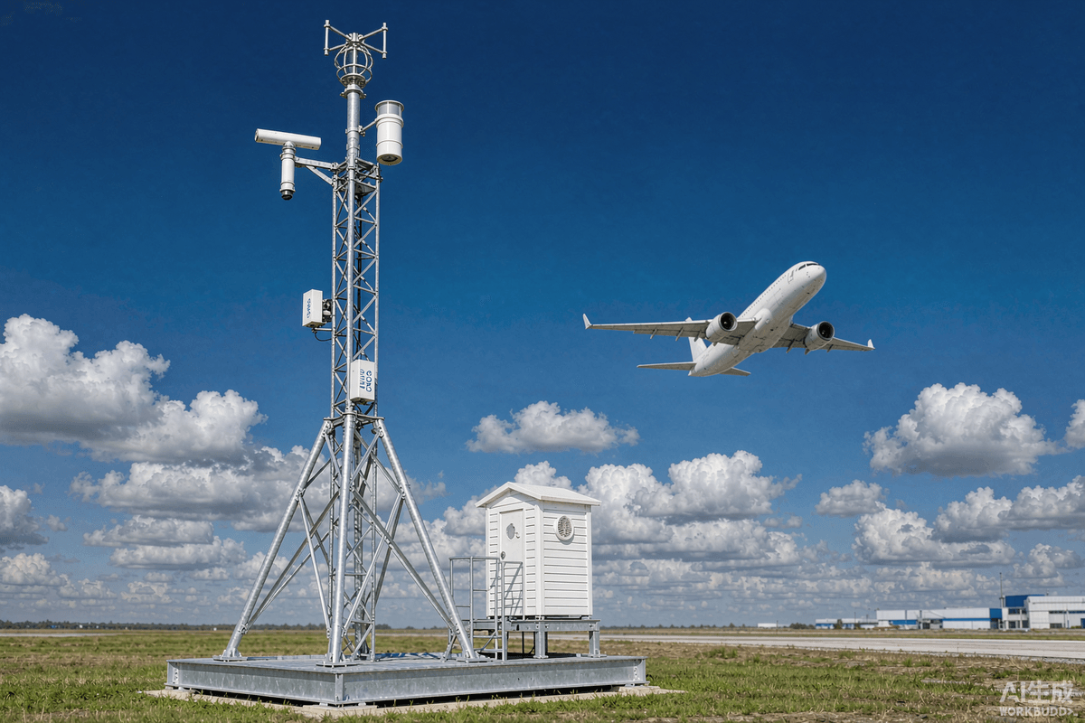
Figure 1 — An AWOS station beside a runway: ultrasonic wind sensor, ceilometer, visibility sensor, and a Stevenson screen for temperature/humidity.
1. What Is an AWOS?
An Automated Weather Observing System (AWOS) is an airport-based meteorological system that automatically measures, processes, and reports real-time weather conditions to support safe and efficient flight operations. It continuously collects data from a suite of precision sensors — wind, visibility, cloud height, temperature, dew point, pressure, and precipitation — reduces and analyzes that data by computer, and broadcasts coded weather reports that aircraft can receive up to 10,000 feet above ground level and 25 nautical miles from the airport.
An AWOS (Automated Weather Observing System) is a sensor-based airport weather station that automatically measures wind speed and direction, visibility, cloud height, temperature, dew point, and barometric pressure, then converts those readings into coded METAR and SPECI aviation weather reports for pilots and air traffic controllers.
According to the FAA's governing specification, Advisory Circular AC 150/5220-16E, an AWOS 'automatically measures meteorological parameters, reduces and analyzes the data via computer, and broadcasts weather reports.' This single definition captures the system's three essential functions: sensing, processing, and dissemination.
2. Why Automated Weather Observation Matters
Weather affects v
irtually every operation at an airport. Wind determines runway selection and crosswind limits; visibility and cloud ceiling dictate whether an approach can be flown; temperature and pressure drive take-off performance calculations; and precipitation, fog, and thunderstorms create hazards that can delay or shut down operations entirely.
Traditionally, weather was observed by trained human meteorologists who visually estimated visibility and cloud cover. While valuable, manual observation is labor-intensive, prone to human error, and — critically — cannot provide the continuous, 24/7 coverage that modern all-weather operations demand. Automated systems remove this constraint, delivering objective, repeatable measurements around the clock, including at remote and northern sites where human observation would otherwise be limited or unavailable.
The operational payoff is substantial. Accurate, real-time weather data helps airlines optimize routes and reduce delays, supports controllers in sequencing traffic safely in poor visibility, and underpins the regulatory minimums that govern whether an aircraft may land at all. In effect, the AWOS is the foundation of an airport's Low-Visibility Operations capability.
Weather is also the single largest cause of air-traffic delay. Industry analyses consistently rank weather as the leading source of flight delays, accounting for the majority of delay minutes across major networks, with thunderstorms (convection), low visibility, and winter precipitation among the top contributors. Every minute of avoidable delay carries a real cost — in fuel, crew time, missed connections, and passenger compensation — which is precisely why airports and air navigation service providers invest in accurate, continuous, and automated weather observation rather than relying on periodic human estimates.
3. AWOS vs. ASOS vs. AWSS: What Is the Difference?
The acronyms AWOS, ASOS, and AWSS are frequently used interchangeably, but they refer to distinct system lineages. Understanding the difference matters for procurement and compliance.
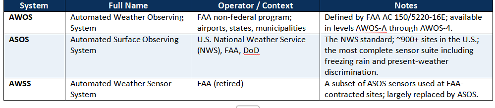
In practice, both AWOS and ASOS produce the same type of output — coded METAR and SPECI reports — and a pilot receiving a broadcast generally cannot tell the difference by ear. The distinction is administrative: who owns and operates the system, and which certification standard it was commissioned under.
4. AWOS Components and Sensors
An AWOS is a system of systems. Each sensor is optimized for a single meteorological parameter and sited according to strict criteria so that its readings are representative of the airport as a whole. The core sensor suite includes:
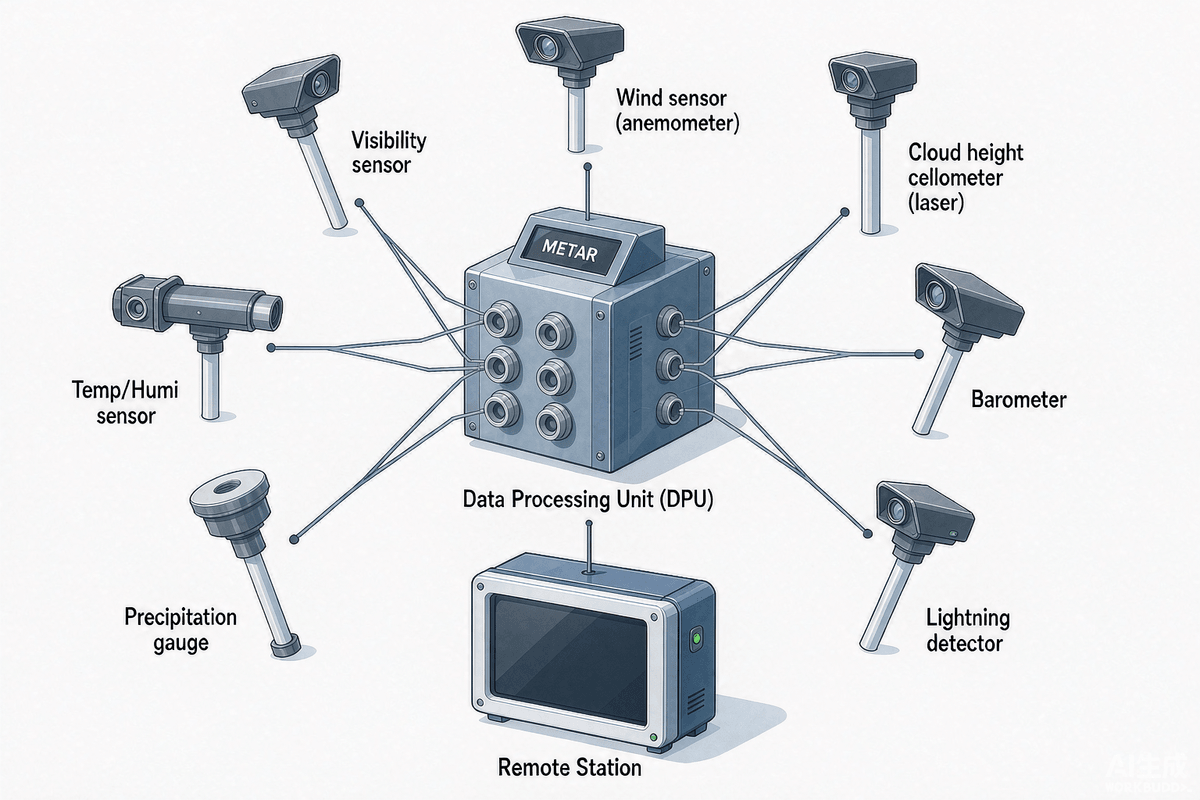
Figure 2 — AWOS component architecture: field sensors feed a central data processing unit that generates METAR/SPECI reports and distributes them to ATC, pilots, and forecast systems.
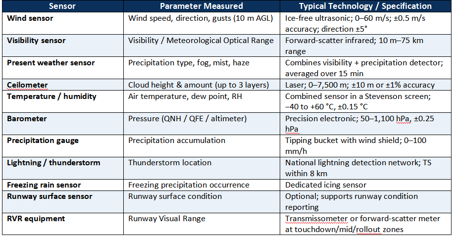
Under the FAA non-federal program, AWOS systems are classified into levels that define the minimum sensor set and, therefore, the weather elements they report. A higher level does not change the accuracy of individual sensors — it adds additional parameters. This tiered structure lets smaller airports commission a cost-effective basic system and upgrade later as traffic grows.

A full AWOS-4 closely approximates the capability of an ASOS. Airports operating Low-Visibility Procedures (LVP) or Category II/III approaches will typically require the RVR and cloud-ceiling reporting that only the higher levels provide.
6. How an AWOS Generates METAR and SPECI Reports
The heart of the AWOS is its data processing unit (DPU). The DPU polls every sensor, applies certified algorithms and quality-assurance checks, and composes standardized reports. The two report types are:
· METAR — the routine hourly (or half-hourly) aerodrome weather report, published to international standards.
· SPECI — a special report issued whenever conditions cross defined thresholds (for example, visibility dropping below a landing minimum) or change rapidly.
Automated reports carry distinctive characteristics that pilots must understand. Because a ceilometer only views the sky directly above it, automated observations report 'NCD' (No Cloud Detected) rather than 'SKC' (Sky Clear), and cloud-type codes (towering cumulus, cumulonimbus) are replaced with '///'. Similarly, because the visibility sensor is a spot measurement, directional variation in visibility and 'vicinity' (VC) weather are not reported. These are not errors — they are inherent, well-understood properties of automated observing.
A typical AWOS report is transmitted over a telecommunication circuit and published internationally, while real-time data is updated every minute and broadcast over a local VHF frequency (or via ATIS) that pilots can tune into in the vicinity of the airport. The same data feeds air-traffic-management displays for controllers and meteorologists.
7. Runway Visual Range (RVR) and Low-Visibility Operations
Runway Visual Range (RVR) is the range over which a pilot on the runway centerline can see the runway surface markings or the lights delineating the runway. RVR is the single most important AWOS-derived parameter for low-visibility landings, because approach minimums are expressed in RVR, not in generic visibility.
RVR is measured by transmissometers or forward-scatter meters installed at up to three positions along the runway — touchdown zone, midpoint, and rollout (stop-end). By combining RVR with cloud ceiling, an airport determines which approach category is available:

The higher the approach category an airport supports, the more accurate and redundant its RVR and ceiling measurement must be. This is a primary driver of AWOS specification for major hub airports — and the reason critical AWOS functions are often duplicated to guarantee uninterrupted data flow.
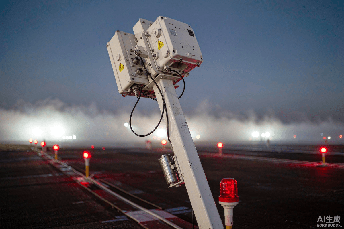
Figure 3 — RVR transmissometer and forward-scatter sensors at the runway edge, feeding the visibility data that governs low-visibility approach minimums.
8. Regulatory Standards: FAA, ICAO, and WMO
AWOS design, siting, and reporting are governed by a layered international and national regulatory framework. Any airport procuring or modernizing an AWOS must align with all three levels.
• FAA — Advisory Circular AC 150/5220-16E defines the certification, performance, and testing specifications for non-federal AWOS systems used in the U.S. National Airspace System, including per-sensor accuracy tolerances and siting criteria.
• ICAO — Annex 3 — Meteorological Service for International Air Navigation sets the global standards for aerodrome meteorological observation and the METAR/SPECI code format.
• WMO — World Meteorological Organization standards underpin sensor measurement methods and the Manual on Codes, harmonizing how weather data is encoded worldwide.
Compliance is not optional. In most jurisdictions, an AWOS must be certified by the relevant civil-aviation authority before its reports may be used to satisfy operational weather-observation requirements. Certified systems appear on an approved list (such as the FAA's Certified Non-Federal AWOS list), and only these approved makes and models may be deployed.
9. Siting and Deployment Best Practices
An AWOS is only as good as its siting. Sensors must be placed where their readings are representative of the aerodrome, away from obstructions, buildings, and heat sources that could bias the measurement.
· Wind sensors are mounted on a 10-metre mast adjacent to the runway, clear of local turbulence, so the reported wind represents the approach/take-off corridor.
· Visibility and present-weather sensors are sited at a representative location on the aerodrome; because they are spot measurements, their position is chosen to reflect the critical runway zone.
· Ceilometers are installed with an unobstructed vertical view, typically near the touchdown zone.
· Temperature/humidity sensors are housed in a standard meteorological screen to avoid solar and ground-radiation errors.
· RVR transmissometers are aligned along the runway centerline at touchdown, midpoint, and rollout positions.
Power, data redundancy, and lightning/EMI protection are also mandatory design considerations — the FAA specification devotes entire chapters to electromagnetic interference, transient, and lightning protection, reflecting the safety-critical nature of continuous weather data.
10. AWOS Market Size and Growth
The global airport AWOS market is growing steadily, driven by mandatory meteorological reporting requirements and the modernization of aging airport infrastructure. According to PW Consulting, the airport AWOS market was valued at approximately USD 580 million in 2025 and is projected to reach USD 843.7 million by 2032, a compound annual growth rate (CAGR) of 5.5%.
Analyst estimates vary with scope: DataHorizzon Research pegged the market at roughly USD 720 million in 2024 (growing at ~7.1% CAGR), while broader definitions of the airport weather-system market produce larger figures. Across all estimates, three trends are consistent:

Sources: PW Consulting AWOS market analysis; DataHorizzon Research AWOS report.
11. Emerging Trends in Airport Weather Automation
AWOS technology is evolving rapidly. Several trends are reshaping what an airport weather system can do:
· AI and machine learning — predictive weathe
r analytics and nowcasting layered on top of raw sensor data to anticipate fog, thunderstorms, and rapid visibility changes.
· IoT and cloud integration — IP-connected sensors streaming to cloud platforms, enabling remote monitoring, fleet-wide diagnostics, and centralized weather management across airport groups.
· Portable and modular AWOS — cost-effective, rapid-deployment systems for regional airports, emergency response, and UAV/drone operations.
· Multi-sensor fusion — combining AWOS with radar, lightning networks, and satellite data for a complete situational picture.
· Integration with ATM and runway-management systems — feeding weather directly into departure/arrival sequencing and runway-condition decision support.
For airport operators, these trends point toward a clear procurement principle: choose an AWOS platform that is modular, standards-compliant, and software-defined, so it can grow with the airport rather than requiring replacement every few years.
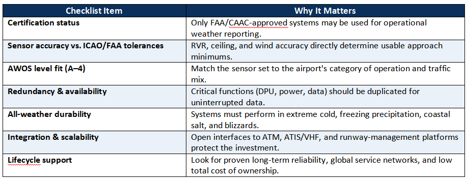
12. Selecting an AWOS: Buyer's Checklist
13. How AWOS Data Is Used Across the Airport
The value of an AWOS lies in how its data flows through the airport's operational ecosystem. A single set of sensor readings serves many distinct users simultaneously:
· Pil
ots — receive automated weather via VHF/ATIS radio and METAR/SPECI before and during approach, informing runway selection, approach category, and go/no-go decisions.
· Air traffic controllers — use real-time wind and RVR to sequence arrivals, select the active runway, and trigger Low-Visibility Procedures when ceilings and visibility drop.
· Airline dispatch and flight planning — use METAR and forecasts to plan fuel loads, alternates, and take-off performance.
· Airport operations and maintenance — monitor present weather to dispatch snow removal, de-icing, and runway treatment at the right time.
· Meteorological offices — ingest AWOS data into forecasts, nowcasts, and long-term climatology.
Because the system is the single source of truth for all these users, data integrity and redundancy are non-negotiable. A failed or drifting sensor does not merely inconvenience one user — it propagates error across the entire operation, which is why certified AWOS systems incorporate continuous self-diagnostics, quality-assurance checks, and duplication of critical functions.
14. AWOS Deployment: Fixed vs. Portable Systems
AWOS platforms divide broadly into fixed and portable categories, and the choice between them is driven less by technology than by the airport's traffic profile and permanence of need.
Fixed AWOS installations are permanent, mast- or tower-mounted systems that dominate the market (roughly 75% share in 2025) and serve airports with regular commercial traffic. They offer siting stability, power and data redundancy, and the certification pedigree required for Low-Visibility Procedures.
Portable AWOS are rapidly deployable, containerized or trailer-mounted units used for temporary operations, emergency response, military deployments, and regional airports where a full fixed installation is not yet justified. They provide flexibility and lower upfront cost, but typically trade away some sensor redundancy and long-term durability.
A growing middle path is the modular AWOS: a fixed core (data processing, power, communications) with swappable sensor modules, allowing airports to start small and upgrade in place — matching the 'one-time planning, phased implementation' principle common in modern smart-airport programs.
15. AWOS Accuracy and Calibration
Certified AWOS sensors must meet explicit accuracy tolerances defined in the governing standard, and the entire system is subject to ongoing performance verification. Typical tolerances include wind speed accuracy of ±0.5 m/s, wind direction ±5°, air temperature ±0.15 °C, relative humidity ±2%, pressure ±0.25 hPa, and cloud height ±10 m or ±1% of measured height.
Accuracy is maintained through a documented maintenance and calibration program. The governing advisory circular specifies routine checks — including sensor performance verification, data-quality review, and preventive maintenance — on defined schedules, with exceptions permitted only through a formal request process. Regular calibration against certified references is essential because even a small bias in visibility or ceiling measurement can shift an airport's effective landing minimum, with direct safety and capacity consequences.
This is why top-tier systems build in continuous self-diagnostics: the data processor monitors each sensor's health and flags drift or failure in real time, so a degrading sensor is corrected before it affects published weather information.
16. Frequently Asked Questions (FAQ)
What is an AWOS and what does it measure?
An Automated Weather Observing System is a sensor-based airport weather station that automatically measures wind speed and direction, visibility, cloud height, temperature, dew point, barometric pressure, and precipitation, then converts these readings into coded METAR and SPECI aviation weather reports.
What is the difference between AWOS and ASOS?
Functionally they produce the same coded weather reports, but they belong to different programs. AWOS refers to FAA non-federal systems (levels AWOS-A through AWOS-4) defined by AC 150/5220-16E, while ASOS is the U.S. National Weather Service system with the most complete sensor suite.
What are the AWOS levels?
AWOS levels describe the sensor set: AWOS-A reports altimeter only; AWOS-1 adds wind, temperature, and dew point; AWOS-2 adds visibility; AWOS-3 adds cloud/ceiling; AWOS-3P adds precipitation; and AWOS-4 adds precipitation type, thunderstorm, freezing rain, and runway visual range.
What is Runway Visual Range (RVR) and why does it matter?
RVR is the distance a pilot on the runway centerline can see runway markings or lights. It determines approach minimums: CAT I requires 550 m, CAT II 300 m, CAT IIIA 175 m, and CAT IIIB 75 m. Accurate RVR is the key enabler of low-visibility landings.
How does an AWOS differ from a manual weather observer?
An AWOS is objective, continuous, and available 24/7, including at remote sites, but its visibility and cloud sensors are spot measurements — so it reports 'NCD' instead of 'SKC' and cannot identify cloud type or vicinity weather the way a human observer can.
How accurate are AWOS sensors?
Modern sensors are highly accurate: ultrasonic wind sensors achieve ±0.5 m/s, temperature sensors ±0.15 °C, barometers ±0.25 hPa, and laser ceilometers ±10 m or ±1% of height. Certification standards set explicit per-sensor tolerances that systems must meet.
How is AWOS data transmitted to pilots?
Real-time weather is updated every minute and broadcast over a local VHF radio frequency or via ATIS, while routine METAR (hourly or half-hourly) and special SPECI reports are transmitted over telecommunication circuits and published internationally. The same data feeds air-traffic-control displays and weather-service portals.
Can an AWOS operate without a human observer?
Yes. Modern AWOS systems run fully automated, generating AUTO METAR reports without human intervention. At many sites, the AWOS acts as an aid to a human observer during operating hours and switches to fully automated observation outside those hours to provide continuous coverage.
What weather elements does a full AWOS-4 report?
A full AWOS-4 reports wind speed, direction, and gusts; temperature; dew point; visibility; sky condition and ceiling; precipitation identification and accumulation; precipitation type; thunderstorm detection; freezing rain; and runway visual range — a sensor suite approaching that of a full ASOS.
Key Takeaways
· An AWOS automatically measures wind, visibility, cloud height, temperature, dew point, pressure, and precipitation, and broadcasts coded METAR/SPECI reports.
· AWOS levels (A through 4) define the sensor set; AWOS-4 adds runway visual range and approaches full ASOS capability.
· RVR is the critical parameter for low-visibility landings, with minimums from 550 m (CAT I) down to 75 m (CAT IIIB).
· Certification (FAA AC 150/5220-16E) and correct siting are non-negotiable for operational use.
· The AWOS market is growing at roughly 5.5%–7.1% CAGR, driven by regulation and airport modernization.
17. Conclusion
The Automated Weather Observing System is the quiet workhorse of modern aviation — an always-on network of precision sensors that turns raw atmospheric data into the objective, standardized reports that keep aircraft moving safely in every kind of weather. From a single AWOS-A at a remote airstrip to a redundant, CAT III-capable AWOS-4 at a major hub, the right system is the foundation of safe, efficient, all-weather operations.
As air traffic grows and airports modernize, the value of accurate, continuous weather observation will only increase. For airports planning a new installation or an upgrade, the priorities are clear: certify, size correctly to the level of operation, and invest in a modular, future-proof platform.
Haisen Global supplies and integrates aviation weather and runway-safety technologies for airports worldwide. For a tailored AWOS deployment plan, sensor specification, or quotation, contact our team.