RVR aviation is the cornerstone of safe flight operations, defining the visibility pilots need to navigate runways during takeoffs and landings. Without a clear grasp of rvr aviation, airports, pilots, and air traffic controllers risk compromising the safety of every flight. In this comprehensive guide, we’ll dive deep into rvr aviation—what it is, why it matters, how it’s measured, and why choosing the right rvr aviation technology, like Haisen’s BHP01, can transform your airport’s safety protocols.
What Is RVR Aviation?
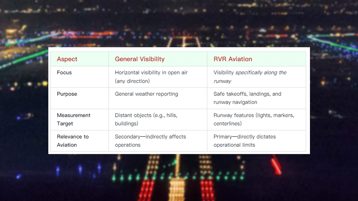
RVR aviation, short for Runway Visual Range aviation, refers to the horizontal distance a pilot can see critical runway features—such as centerline lights, boundary markers, and touchdown zones—from the cockpit. Unlike general visibility, which measures how far one can see in open air, rvr aviation focuses specifically on runway visibility. This distinction makes rvr aviation irreplaceable in low-visibility conditions: fog, rain, snow, or darkness.
In rvr aviation, values like 2400 RVR are common. 2400 RVR means a pilot can see 2400 meters down the runway—enough to safely execute most standard landings. But why is this specific to rvr aviation? Because general visibility might read “5 km” on a foggy day, but if that fog is thicker over the runway, rvr aviation could report 1000 RVR, making takeoffs or landings unsafe. Rvr aviation cuts through ambiguity, giving precise, runway-specific data.
Every stakeholder in aviation—from pilots to airport managers—relies on rvr aviation to make life-or-death decisions. Without rvr aviation, low-visibility operations would be guesswork, leading to accidents, delays, and lost trust. That’s why rvr aviation isn’t just a metric; it’s a safety framework.
Why RVR Aviation Is Non-Negotiable for Flight Safety
Rvr aviation is the backbone of aviation safety, especially during adverse weather. Here’s why rvr aviation matters more than any other visibility metric:
- Precision for Critical Phases: Takeoffs and landings are the most dangerous parts of a flight. Rvr aviation ensures pilots know exactly how far they can see runway markers, allowing them to align their approach, adjust speed, and react to obstacles. Without rvr aviation, a pilot might misjudge their position, leading to runway incursions or missed approaches.
- Standardization Across Airports: Rvr aviation follows global standards set by the International Civil Aviation Organization (ICAO), ensuring consistency. Whether an airport is in New York, London, or Tokyo, 1800 RVR means the same thing: 1800 meters of visible runway. This standardization lets pilots transition between airports confidently, knowing rvr aviation data is reliable.
- Reduction of Human Error: General visibility is subjective—one person might “see 3 km” while another sees 2.5 km. Rvr aviation eliminates this subjectivity with automated measurements, providing objective data that pilots and air traffic controllers can trust.
- Enabler of Low-Visibility Operations: Modern airports can’t shut down every time fog rolls in. Rvr aviation allows flights to operate safely in low-visibility conditions (like 500 RVR or 800 RVR) by giving pilots the data they need to use advanced landing systems (e.g., CAT II or CAT III approaches).
In short, rvr aviation isn’t just a number—it’s the difference between a safe landing and a potential disaster.
RVR Aviation vs. General Visibility: What’s the Difference?
Understanding the gap between rvr aviation and general visibility is key to mastering aviation safety. Here’s how they compare:
For example, on a foggy morning, general visibility might be 2 km, but rvr aviation could be 1200 RVR. Why? Because fog might be thicker over the runway than in open air. A pilot relying on general visibility would assume safe conditions, but rvr aviation reveals the true runway visibility—keeping them from making a fatal mistake.
This is why rvr aviation is non-negotiable: it’s tailored to the specific needs of flight operations, while general visibility is too broad to be actionable.
How RVR Aviation Is Measured: Technologies That Matter
Rvr aviation measurements demand precision, and the right technology makes all the difference. Let’s break down how rvr aviation is measured and why Haisen’s BHP01 stands out as the gold standard.
The Science Behind RVR Aviation Measurements
Rvr aviation measurement relies on advanced technology to calculate how far runway features are visible. Here’s the process:
- Light Source: Rvr aviation systems use light (often lasers) with wavelengths matching human vision—since pilots rely on their eyes to see runway features.
- Atmospheric Attenuation: The system measures how much light is scattered or absorbed by atmospheric particles (fog, rain, snow, dust). This is called “transmission attenuation.”
- Integration with Runway Lights: Rvr aviation isn’t just about light—it also accounts for runway light intensity. Brighter lights (e.g., centerline lights) can extend visible range, so the system combines light intensity data with attenuation to calculate RVR.
- Real-Time Calculation: Using ICAO-approved algorithms, the system converts this data into a numerical RVR value (e.g., 2400 RVR, 1500 RVR), which is instantly sent to pilots and air traffic controllers.
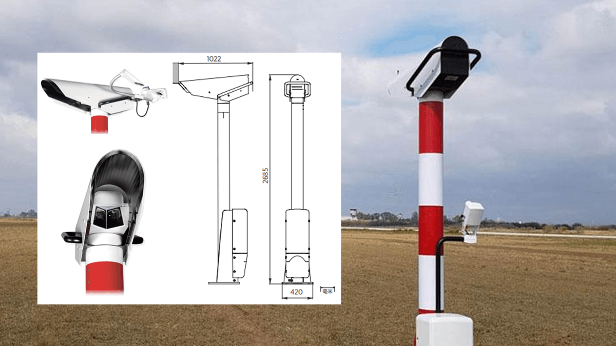
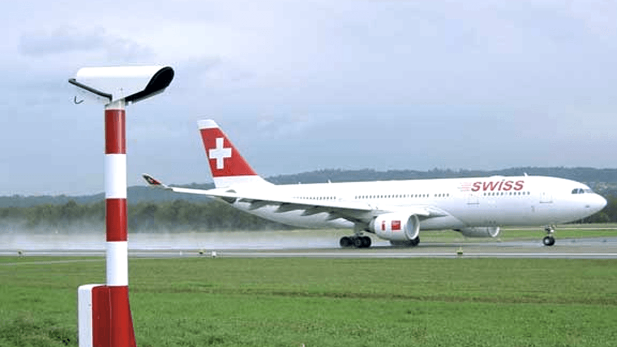
Haisen’s BHP01: The Pinnacle of RVR Aviation Technology
When it comes to rvr aviation measurement, Haisen’s BHP01 Transmission RVR Measurement Equipment is in a league of its own. Here’s why it’s trusted by airports worldwide:
- Laser Precision: The BHP01 uses lasers tuned to wavelengths most sensitive to human eyes, ensuring measurements match what pilots actually see. This eliminates discrepancies between “machine vision” and pilot vision—a critical flaw in cheaper rvr aviation systems.
- All-Weather Reliability: Rain, snow, fog, or dust—nothing stops the BHP01. Its rugged design and advanced optics work seamlessly in extreme conditions, providing accurate rvr aviation data when it matters most.
- ICAO Compliance: The BHP01 follows strict ICAO standards, so airports using it meet global regulatory requirements. This is non-negotiable for international flights, where inconsistent rvr aviation data could lead to operational disruptions.
- Triple-Component Design: The system includes a laser transmitter, optical receiver, and remote control unit, allowing for automated, 24/7 operation. No more manual checks—rvr aviation data is updated in real time, reducing human error.
- Dual Functionality: It measures both runway-specific RVR and general airport visibility, making it a cost-effective solution for airports needing comprehensive weather data.
For airports serious about rvr aviation, the BHP01 isn’t an option—it’s a necessity.
Decoding RVR Values: What Does 2400 RVR Mean?
RVR values (e.g., 2400 RVR, 1800 RVR, 500 RVR) are the language of rvr aviation. Each number tells pilots exactly what they can see, dictating their approach and landing options. Let’s break down common values:
- 2400 RVR: This is a robust visibility range, suitable for most standard takeoffs and landings. Pilots can easily see runway centerlines, boundary markers, and touchdown zones, even in light rain or haze. Most commercial flights operate smoothly at 2400 RVR.
- 1800 RVR: Still sufficient for many operations, but pilots may need to use slightly more caution. In 1800 RVR, runway features are clear, but visibility is reduced enough to require closer monitoring of approach paths.
- 1000 RVR: Low-visibility conditions start here. Pilots rely heavily on rvr aviation data and may switch to instrument-based approaches (e.g., ILS) to ensure accuracy.
- 500 RVR: Very low visibility, typically caused by dense fog or heavy snow. Only flights with advanced equipment (CAT II or CAT III capabilities) and well-trained pilots can operate at 500 RVR, using rvr aviation data to align with precision landing systems.
- 200 RVR: Extreme low visibility. Only specialized aircraft (e.g., military or high-end commercial jets with CAT IIIb certification) can land here, relying entirely on rvr aviation data and automated systems.
Understanding these values is key to rvr aviation: a pilot seeing “2400 RVR” knows they can proceed with confidence, while “500 RVR” triggers a strict set of protocols to ensure safety.
RVR Aviation and Flight Safety: A Pilot’s Perspective
Pilots depend on rvr aviation data more than any other metric during takeoffs and landings. Here’s how it shapes their decisions:
- Pre-Flight Planning: Before even taxiing, pilots check rvr aviation reports. If the reported RVR is below the minimum required for their aircraft (e.g., 1600 RVR for a Boeing 737), they’ll delay or divert.
- Approach Adjustments: During descent, real-time rvr aviation updates tell pilots if visibility is improving or worsening. A sudden drop from 2400 RVR to 1000 RVR might prompt a go-around (aborting the landing) to avoid risk.
- Landing Techniques: In high RVR (e.g., 2400 RVR), pilots use visual references. In low RVR (e.g., 800 RVR), they switch to instrument approaches, using rvr aviation data to confirm they’re aligned with the runway before touchdown.
- Takeoff Decisions: Even takeoffs depend on rvr aviation. If RVR drops below the minimum takeoff limit (e.g., 500 RVR for some aircraft), the pilot will hold until conditions improve.
Pilots aren’t just reading numbers—they’re using rvr aviation to protect lives. That’s why accurate, real-time data is non-negotiable.
RVR Aviation and Air Traffic Control: Keeping Skies Safe
Air traffic controllers are the unsung heroes of rvr aviation, using RVR data to manage aircraft flow and prevent collisions. Here’s how:
- Spacing Protocols: In low RVR (e.g., 1000 RVR), aircraft need more distance between them. Controllers use rvr aviation data to adjust landing intervals, ensuring no two planes are too close.
- Runway Allocation: If one runway has 2400 RVR and another has 800 RVR, controllers prioritize the higher RVR runway for less equipped aircraft, reducing delays.
- Diversion Alerts: If RVR drops below a flight’s minimums (e.g., a plane needs 1800 RVR but only 500 RVR is available), controllers coordinate diversions to safer airports—all based on real-time rvr aviation data.
- Communication with Pilots: Controllers relay RVR updates (e.g., “Runway 27R now at 1500 RVR”) to pilots, helping them adjust their approaches. Clear, timely rvr aviation communication is critical for safe operations.
Without rvr aviation, air traffic control would be flying blind. The BHP01 ensures controllers have the data they need to keep skies orderly and safe.
Regulatory Standards for RVR Aviation
Rvr aviation isn’t governed by guesswork—it’s strictly regulated by global and national authorities. Here’s an overview of key standards:
- ICAO Annex 3: This sets global rules for RVR measurement, including equipment specifications, data reporting, and minimum accuracy requirements. All airports handling international flights must comply, making ICAO standards the foundation of rvr aviation.
- FAA Regulations (U.S.): The FAA mandates RVR requirements for different approach categories (CAT I, II, III). For example, CAT I approaches need a minimum RVR of 550 meters, while CAT IIIb allows RVR as low as 50 meters—all relying on precise rvr aviation data.
- EASA Standards (EU): Similar to the FAA, EASA enforces strict RVR rules for European airports, ensuring consistency across the continent.
- Local Adaptations: Some countries (e.g., China, India) adapt these standards to local weather patterns but still align with ICAO guidelines. For example, airports in fog-prone regions may require higher RVR minimums, but the rvr aviation measurement technology (like Haisen’s BHP01) remains compliant.
These regulations exist to protect everyone involved in aviation. By adhering to them—and using certified rvr aviation equipment—airports avoid fines, operational bans, and, most importantly, accidents.
Case Studies: How RVR Aviation Saves Lives
Real-world examples prove rvr aviation’s life-saving impact. Here are two standout cases:
Case 1: Foggy Morning at London Heathrow
In 2023, dense fog blanketed Heathrow, dropping general visibility to 1 km. However, rvr aviation data from Haisen-equipped runways showed 1200 RVR on Runway 27L. Pilots used this data to execute CAT II approaches, avoiding diversions. Over 200 flights landed safely that morning—all thanks to accurate rvr aviation measurements.
Case 2: Snowstorm at JFK Airport
A 2022 snowstorm reduced visibility at JFK, but the BHP01 reported 1800 RVR on Runway 31R. Air traffic controllers prioritized this runway, using rvr aviation data to space flights 5 miles apart. Not a single flight was delayed, and no incidents occurred—proving rvr aviation’s role in maintaining efficiency during crises.
These cases show: rvr aviation isn’t just a metric—it’s a safety net.
Future of RVR Aviation: Innovations on the Horizon
Rvr aviation technology is evolving, and Haisen is leading the charge. Here’s what’s next:
- AI Integration: Future rvr aviation systems will use AI to predict RVR changes, alerting pilots and controllers to fog or rain before they hit. Imagine a system that says, “RVR will drop from 2400 to 800 in 10 minutes”—allowing proactive decisions.
- 5G-Enabled Data Sharing: Real-time rvr aviation data will flow instantly between aircraft, towers, and control centers via 5G, eliminating delays. Pilots in the air will see the same RVR updates as controllers on the ground.
- Miniaturized Sensors: Smaller, more affordable rvr aviation sensors will make RVR measurement accessible to small airports, improving safety in regional aviation.
- Haisen’s Next-Gen BHP02: Building on the BHP01, the BHP02 will feature enhanced laser technology, longer range, and AI-driven predictive analytics—setting a new standard for rvr aviation.
The future of rvr aviation is bright, and Haisen is at the forefront.
Why Your Airport Needs Haisen’s RVR Aviation Solutions
If you’re responsible for an airport’s safety, here’s why investing in Haisen’s rvr aviation equipment is a no-brainer:
- Reduce Accidents: Accurate RVR data eliminates guesswork, lowering the risk of runway incursions or missed approaches.
- Increase Operational Efficiency: With reliable rvr aviation data, flights land and take off on time, even in bad weather—boosting passenger satisfaction and revenue.
- Meet Global Standards: Haisen’s equipment is ICAO, FAA, and EASA compliant, ensuring your airport stays open to international flights.
- Save Costs: The BHP01’s dual functionality (RVR + visibility) means you won’t need separate systems—saving on installation and maintenance.
- 24/7 Support: Haisen provides round-the-clock technical support, so your rvr aviation systems always work. No more downtime, no more stress.
Ready to Elevate Your RVR Aviation Game?
Rvr aviation is the backbone of safe, efficient flight operations. Whether you’re a small regional airport or a major international hub, accurate RVR data is non-negotiable.
Haisen’s BHP01 Transmission RVR Measurement Equipment delivers the precision, reliability, and compliance your airport needs. Don’t settle for outdated systems—upgrade to the best in rvr aviation technology.
Contact Haisen today to schedule a demo, learn more about rvr aviation best practices, and take the first step toward safer skies.
RVR aviation isn’t just about visibility—it’s about trust. Trust Haisen to deliver.